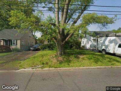
622 Sampson Ave Willow Grove, PA 19090
Estimated Value: $380,000 - $447,000
3
Beds
2
Baths
1,458
Sq Ft
$276/Sq Ft
Est. Value
About This Home
This home is located at 622 Sampson Ave, Willow Grove, PA 19090 and is currently estimated at $402,744, approximately $276 per square foot. 622 Sampson Ave is a home located in Montgomery County with nearby schools including Upper Moreland Intermediate School, Upper Moreland Primary School, and Upper Moreland Middle School.
Ownership History
Date
Name
Owned For
Owner Type
Purchase Details
Closed on
Dec 6, 2017
Sold by
Gina Maria Kendall Estate
Bought by
Kendall Christina E
Current Estimated Value
Purchase Details
Closed on
Jul 23, 2010
Sold by
Powers James W
Bought by
Kendall Christina E and Kendall Gina Maria
Purchase Details
Closed on
Mar 16, 2007
Sold by
Bevan Stephen G
Bought by
Powers James W
Home Financials for this Owner
Home Financials are based on the most recent Mortgage that was taken out on this home.
Original Mortgage
$21,950
Interest Rate
6.33%
Purchase Details
Closed on
Jan 31, 2002
Sold by
Bevan Nancy S and Bevan Stephen G
Bought by
Bevan Stephen G
Purchase Details
Closed on
Sep 23, 1994
Sold by
Ward John S and Ward Beverly
Bought by
Bevan Nancy S and Bevan Stephen G
Create a Home Valuation Report for This Property
The Home Valuation Report is an in-depth analysis detailing your home's value as well as a comparison with similar homes in the area
Home Values in the Area
Average Home Value in this Area
Purchase History
| Date | Buyer | Sale Price | Title Company |
|---|---|---|---|
| Kendall Christina E | -- | -- | |
| Kendall Christina E | $226,300 | None Available | |
| Powers James W | $219,500 | None Available | |
| Bevan Stephen G | -- | T A Title Insurance Company | |
| Bevan Nancy S | $120,000 | T A Title Insurance Company |
Source: Public Records
Mortgage History
| Date | Status | Borrower | Loan Amount |
|---|---|---|---|
| Previous Owner | Powers James W | $21,950 | |
| Previous Owner | Powers James W | $175,600 | |
| Previous Owner | Bevan Stephen G | $200,700 | |
| Previous Owner | Bevan Stephen G | $120,500 | |
| Previous Owner | Bevan Stephen G | $31,000 |
Source: Public Records
Tax History Compared to Growth
Tax History
| Year | Tax Paid | Tax Assessment Tax Assessment Total Assessment is a certain percentage of the fair market value that is determined by local assessors to be the total taxable value of land and additions on the property. | Land | Improvement |
|---|---|---|---|---|
| 2024 | $5,211 | $109,630 | $48,530 | $61,100 |
| 2023 | $4,995 | $109,630 | $48,530 | $61,100 |
| 2022 | $4,697 | $109,630 | $48,530 | $61,100 |
| 2021 | $4,634 | $109,630 | $48,530 | $61,100 |
| 2020 | $4,481 | $109,630 | $48,530 | $61,100 |
| 2019 | $4,383 | $109,630 | $48,530 | $61,100 |
| 2018 | $4,383 | $109,630 | $48,530 | $61,100 |
| 2017 | $4,187 | $109,630 | $48,530 | $61,100 |
| 2016 | $4,143 | $109,630 | $48,530 | $61,100 |
| 2015 | $3,933 | $109,630 | $48,530 | $61,100 |
| 2014 | $3,933 | $109,630 | $48,530 | $61,100 |
Source: Public Records
Map
Nearby Homes
- 810 Patterson Ave
- 1006 N York Rd Unit 15
- 885 N York Rd Unit 12C
- 229 Warren St
- 233 Fairhill St
- 515 N York Rd Unit 3-A
- 324 Cameron Rd
- 251 Lawnton Rd
- 122 Ellis Rd
- 705 Burbridge Rd
- 240 Cowbell Rd
- 547 S Warminster Rd
- 1948 Lukens Ave
- 1944 Fleming Ave
- 1972 Coolidge Ave
- 179 Campmeeting Rd
- 2410 Huntingdon Rd
- 2304 Terwood Rd
- 1908 Fleming Ave
- 2335 Terwood Rd
- 622 Sampson Ave
- 624 Sampson Ave
- 620 Sampson Ave
- 618 Sampson Ave
- 611 Brook St
- 615 Brook St
- 614 Sampson Ave
- 632 Sampson Ave
- 625 Sampson Ave
- 617 Sampson Ave
- 629 Sampson Ave
- 609 Brook St
- 613 Sampson Ave
- 610 Sampson Ave
- 621 Brook St
- 633 Sampson Ave
- 609 Sampson Ave
- 637 Sampson Ave
- 606 Sampson Ave
- 607 Sampson Ave
