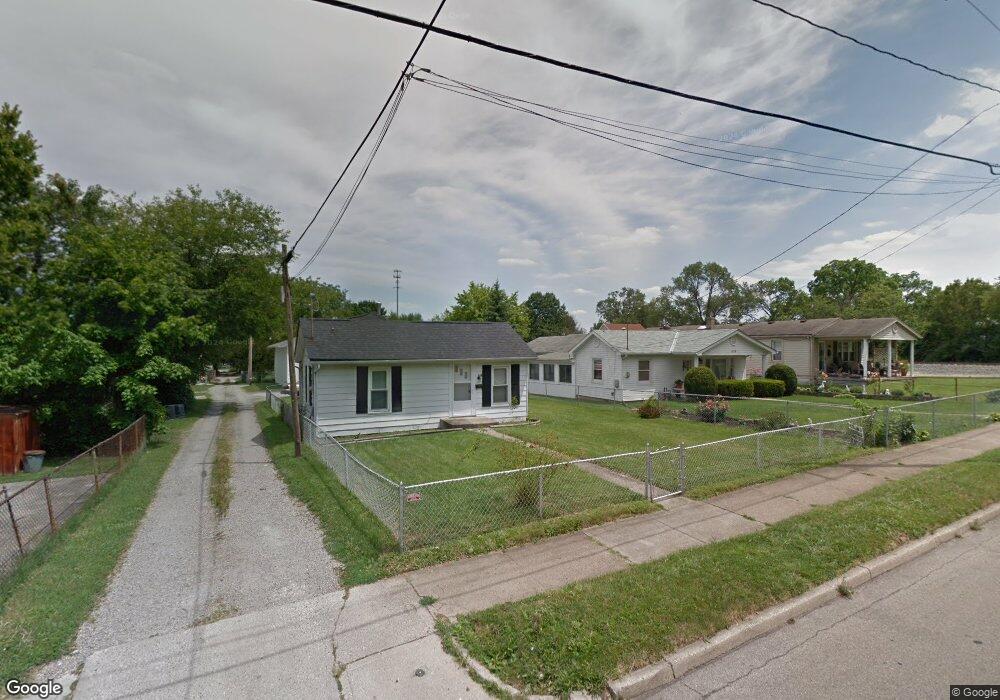
624 Kenworth Ave Hamilton, OH 45013
Estimated Value: $108,695 - $150,000
2
Beds
1
Bath
614
Sq Ft
$210/Sq Ft
Est. Value
About This Home
This home is located at 624 Kenworth Ave, Hamilton, OH 45013 and is currently estimated at $129,174, approximately $210 per square foot. 624 Kenworth Ave is a home located in Butler County with nearby schools including Highland Elementary School, Wilson Middle School, and Hamilton High School Main Campus.
Ownership History
Date
Name
Owned For
Owner Type
Purchase Details
Closed on
Dec 11, 2019
Sold by
Tribby Karen L
Bought by
Mcwhorter James
Current Estimated Value
Purchase Details
Closed on
Feb 25, 2011
Sold by
Reid Edward W and Reid Paula I
Bought by
Reid Properties Llc
Purchase Details
Closed on
Jan 7, 2009
Sold by
Reid Edward W and Reid Paula L
Bought by
Reid Edward W and Reid Paula L
Purchase Details
Closed on
Jul 27, 1998
Sold by
Bartels Thomas A and Bartels Opal
Bought by
Reid Edward W and Reid Paula L
Home Financials for this Owner
Home Financials are based on the most recent Mortgage that was taken out on this home.
Original Mortgage
$44,925
Interest Rate
7.03%
Mortgage Type
Purchase Money Mortgage
Purchase Details
Closed on
Apr 1, 1986
Create a Home Valuation Report for This Property
The Home Valuation Report is an in-depth analysis detailing your home's value as well as a comparison with similar homes in the area
Home Values in the Area
Average Home Value in this Area
Purchase History
| Date | Buyer | Sale Price | Title Company |
|---|---|---|---|
| Mcwhorter James | $59,400 | None Available | |
| Reid Properties Llc | -- | None Available | |
| Reid Edward W | -- | Attorney | |
| Reid Edward W | $59,900 | -- | |
| -- | $23,500 | -- |
Source: Public Records
Mortgage History
| Date | Status | Borrower | Loan Amount |
|---|---|---|---|
| Previous Owner | Reid Edward W | $44,925 |
Source: Public Records
Tax History Compared to Growth
Tax History
| Year | Tax Paid | Tax Assessment Tax Assessment Total Assessment is a certain percentage of the fair market value that is determined by local assessors to be the total taxable value of land and additions on the property. | Land | Improvement |
|---|---|---|---|---|
| 2024 | $973 | $22,450 | $6,090 | $16,360 |
| 2023 | $968 | $22,450 | $6,090 | $16,360 |
| 2022 | $892 | $17,670 | $6,090 | $11,580 |
| 2021 | $799 | $17,190 | $6,090 | $11,100 |
| 2020 | $832 | $17,190 | $6,090 | $11,100 |
| 2019 | $1,181 | $16,130 | $5,780 | $10,350 |
| 2018 | $771 | $16,130 | $5,780 | $10,350 |
| 2017 | $778 | $16,130 | $5,780 | $10,350 |
| 2016 | $778 | $15,380 | $5,780 | $9,600 |
| 2015 | $774 | $15,380 | $5,780 | $9,600 |
| 2014 | $809 | $15,380 | $5,780 | $9,600 |
| 2013 | $809 | $17,110 | $5,780 | $11,330 |
Source: Public Records
Map
Nearby Homes
- 1038 Hunt Ave
- 639 S Mckinley Ave
- 451 Millville Ave
- 1122 Franklin St
- 1150 Franklin St
- 570 Harrison Ave
- 1028 Ross Ave
- 1231 Franklin St
- 834 Ross Ave
- 762 Coralie Ave
- 415 Hyde Park Dr
- 997 Millikin St
- 1317 Goodman Ave
- 405 Hyde Park Dr
- 714 Franklin St
- 197 Millville Ave
- 346 Hyde Park Dr
- 1607 Cereal Ave
- 1317 Glenbrook Dr
- 609 Coralie Ave
- 1031 Hunt Ave
- 1033 Hunt Ave
- 634 Kenworth Ave
- 615 Barnard Ave
- 1029 Hunt Ave
- 1039 Hunt Ave
- 646 Kenworth Ave
- 1041 Hunt Ave
- 1027 Hunt Ave
- 644 Kenworth Ave
- 1025 Hunt Ave
- 1045 Hunt Ave
- 621 Barnard Ave
- 623 Barnard Ave
- 627 Barnard Ave
- 645 Kenworth Ave
- 1101 Hunt Ave
- 1030 Hunt Ave
- 612 Barnard Ave
- 614 Barnard Ave