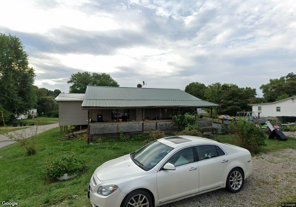
624 Maple St West Union, OH 45693
Estimated Value: $106,507 - $145,000
2
Beds
1
Bath
936
Sq Ft
$133/Sq Ft
Est. Value
About This Home
This home is located at 624 Maple St, West Union, OH 45693 and is currently estimated at $124,377, approximately $132 per square foot. 624 Maple St is a home located in Adams County with nearby schools including West Union Elementary School, West Union High School, and Adams County Christian School.
Ownership History
Date
Name
Owned For
Owner Type
Purchase Details
Closed on
Jun 29, 2022
Sold by
Patricia Menke
Bought by
Davenport Ashley R and Davenport Ashley
Current Estimated Value
Purchase Details
Closed on
May 18, 2021
Sold by
Scott John Lee
Bought by
Menke Patricia
Purchase Details
Closed on
Sep 3, 2002
Sold by
Allen Ruby
Bought by
Scott John Lee
Purchase Details
Closed on
Apr 2, 1998
Sold by
Menke Louttie
Bought by
Allen Ruby
Purchase Details
Closed on
Feb 26, 1998
Sold by
Allen Ruby
Bought by
Allen Ruby
Purchase Details
Closed on
Feb 25, 1998
Sold by
Scott John L
Bought by
Menke Louttie
Purchase Details
Closed on
Jan 28, 1997
Sold by
Scott Eugene
Bought by
Scott Eugene
Create a Home Valuation Report for This Property
The Home Valuation Report is an in-depth analysis detailing your home's value as well as a comparison with similar homes in the area
Home Values in the Area
Average Home Value in this Area
Purchase History
| Date | Buyer | Sale Price | Title Company |
|---|---|---|---|
| Davenport Ashley R | -- | Oudell Staved W | |
| Menke Patricia | -- | None Available | |
| Scott John Lee | -- | -- | |
| Allen Ruby | -- | -- | |
| Allen Ruby | -- | -- | |
| Menke Louttie | -- | -- | |
| Scott Eugene | -- | -- |
Source: Public Records
Tax History
| Year | Tax Paid | Tax Assessment Tax Assessment Total Assessment is a certain percentage of the fair market value that is determined by local assessors to be the total taxable value of land and additions on the property. | Land | Improvement |
|---|---|---|---|---|
| 2025 | $1,273 | $29,400 | $5,040 | $24,360 |
| 2024 | $5,643 | $29,400 | $5,040 | $24,360 |
| 2023 | $1,899 | $29,400 | $5,040 | $24,360 |
| 2022 | $1,013 | $17,720 | $3,820 | $13,900 |
| 2021 | $326 | $17,720 | $3,820 | $13,900 |
| 2020 | $333 | $17,720 | $3,820 | $13,900 |
| 2019 | $333 | $17,720 | $3,820 | $13,900 |
| 2018 | $276 | $15,900 | $3,820 | $12,080 |
| 2017 | $272 | $15,900 | $3,820 | $12,080 |
| 2016 | $272 | $15,900 | $3,820 | $12,080 |
| 2015 | $800 | $14,670 | $3,820 | $10,850 |
| 2014 | $555 | $14,670 | $3,820 | $10,850 |
Source: Public Records
Map
Nearby Homes
- 430 Poplar St
- 819 E Main St
- 601 E Main St
- 70 Logans Ln
- 104 N Washington St
- 0.8ac State Route 41
- 12196 State Route 41
- 537 1st St
- 353 Chestnut Ridge Rd
- 305 W Walnut St
- 9727 Ohio 125
- 408 W South St
- 286 & 290 S Market St
- 215 Chesley St
- 917 Logans Ln
- 216 Kurt St
- 1478 Robinson Hollow Rd
- 4400 Chapparal Rd
- 0 State Route 41 Unit 1830107
- 80 Madonna Dr
Your Personal Tour Guide
Ask me questions while you tour the home.