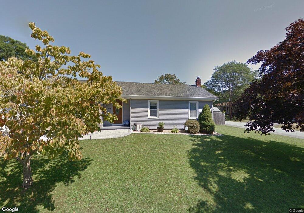
624 Mohawk Rd Somerset, MA 02726
Pottersville NeighborhoodEstimated Value: $612,577 - $711,000
3
Beds
3
Baths
1,750
Sq Ft
$375/Sq Ft
Est. Value
About This Home
This home is located at 624 Mohawk Rd, Somerset, MA 02726 and is currently estimated at $655,894, approximately $374 per square foot. 624 Mohawk Rd is a home located in Bristol County with nearby schools including North Elementary School, Somerset Middle School, and Swansea Wood School.
Ownership History
Date
Name
Owned For
Owner Type
Purchase Details
Closed on
Sep 23, 2022
Sold by
Ytkin Neil A and Ytkin Marjorie
Bought by
Schanil Charles W
Current Estimated Value
Purchase Details
Closed on
Apr 30, 2008
Sold by
Marum Elizabeth A and Marum William V
Bought by
Ytkin Marjorie and Ytkin Neil A
Create a Home Valuation Report for This Property
The Home Valuation Report is an in-depth analysis detailing your home's value as well as a comparison with similar homes in the area
Home Values in the Area
Average Home Value in this Area
Purchase History
| Date | Buyer | Sale Price | Title Company |
|---|---|---|---|
| Schanil Charles W | -- | None Available | |
| Schanil Charles W | -- | None Available | |
| Ytkin Marjorie | $310,000 | -- | |
| Ytkin Marjorie | $310,000 | -- |
Source: Public Records
Mortgage History
| Date | Status | Borrower | Loan Amount |
|---|---|---|---|
| Previous Owner | Ytkin Marjorie | $278,917 | |
| Previous Owner | Ytkin Marjorie | $281,084 | |
| Previous Owner | Ytkin Marjorie | $269,941 |
Source: Public Records
Tax History Compared to Growth
Tax History
| Year | Tax Paid | Tax Assessment Tax Assessment Total Assessment is a certain percentage of the fair market value that is determined by local assessors to be the total taxable value of land and additions on the property. | Land | Improvement |
|---|---|---|---|---|
| 2025 | $5,401 | $471,700 | $157,900 | $313,800 |
| 2024 | $5,115 | $445,200 | $151,900 | $293,300 |
| 2023 | $5,328 | $434,200 | $144,600 | $289,600 |
| 2022 | $4,788 | $379,400 | $133,900 | $245,500 |
| 2021 | $4,701 | $339,900 | $133,600 | $206,300 |
| 2020 | $4,417 | $305,700 | $126,300 | $179,400 |
| 2019 | $4,343 | $297,900 | $123,900 | $174,000 |
| 2018 | $4,123 | $282,000 | $123,900 | $158,100 |
| 2017 | $3,863 | $275,900 | $120,300 | $155,600 |
| 2016 | $3,664 | $268,800 | $120,300 | $148,500 |
| 2015 | $3,550 | $271,400 | $120,300 | $151,100 |
| 2014 | $3,414 | $271,400 | $120,300 | $151,100 |
Source: Public Records
Map
Nearby Homes