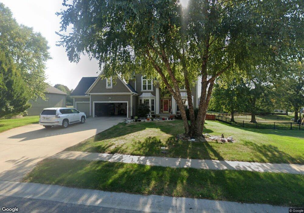
624 NE Sundance Trail Lees Summit, MO 64086
Estimated Value: $597,020 - $646,000
4
Beds
4
Baths
3,484
Sq Ft
$177/Sq Ft
Est. Value
About This Home
This home is located at 624 NE Sundance Trail, Lees Summit, MO 64086 and is currently estimated at $617,505, approximately $177 per square foot. 624 NE Sundance Trail is a home located in Jackson County with nearby schools including Richardson Elementary School, Bernard C. Campbell Middle School, and Lee's Summit North High School.
Ownership History
Date
Name
Owned For
Owner Type
Purchase Details
Closed on
May 29, 2002
Sold by
Richardson Ranch Llc
Bought by
Wyss Construction Llc
Current Estimated Value
Home Financials for this Owner
Home Financials are based on the most recent Mortgage that was taken out on this home.
Original Mortgage
$290,000
Outstanding Balance
$121,162
Interest Rate
6.92%
Mortgage Type
Purchase Money Mortgage
Estimated Equity
$496,343
Create a Home Valuation Report for This Property
The Home Valuation Report is an in-depth analysis detailing your home's value as well as a comparison with similar homes in the area
Home Values in the Area
Average Home Value in this Area
Purchase History
| Date | Buyer | Sale Price | Title Company |
|---|---|---|---|
| Wyss Construction Llc | -- | Stewart Title |
Source: Public Records
Mortgage History
| Date | Status | Borrower | Loan Amount |
|---|---|---|---|
| Open | Wyss Construction Llc | $290,000 |
Source: Public Records
Tax History
| Year | Tax Paid | Tax Assessment Tax Assessment Total Assessment is a certain percentage of the fair market value that is determined by local assessors to be the total taxable value of land and additions on the property. | Land | Improvement |
|---|---|---|---|---|
| 2025 | $6,991 | $111,348 | $15,599 | $95,749 |
| 2024 | $6,991 | $96,824 | $10,716 | $86,108 |
| 2023 | $6,941 | $96,824 | $6,122 | $90,702 |
| 2022 | $7,270 | $90,060 | $13,433 | $76,627 |
| 2021 | $7,421 | $90,060 | $13,433 | $76,627 |
| 2020 | $7,007 | $84,209 | $13,433 | $70,776 |
| 2019 | $6,815 | $84,209 | $13,433 | $70,776 |
| 2018 | $6,260 | $71,773 | $8,838 | $62,935 |
| 2017 | $6,260 | $71,773 | $8,838 | $62,935 |
| 2016 | $5,990 | $67,982 | $9,291 | $58,691 |
| 2014 | -- | $66,101 | $9,291 | $56,810 |
Source: Public Records
Map
Nearby Homes
- 707 NE Sundance Trail
- 908 NE Bristol Dr
- 12416 S Acacia Dr
- 12406 S Acacia Dr
- 12408 S Acacia Dr
- 12404 S Acacia Dr
- 12424 S Redwood St
- 12426 S Redwood St
- 2504 NE Dale Hunter Trail
- 2501 NE Dale Hunter Trail
- 1916 NE Gatewood Dr
- 1905 NE Dill Dr
- 113 SE Bristol Dr
- 100 NE Keystone Dr
- 503 NE Legacy Wood Cir
- 2633 E Langsford Rd
- 116 NE Greystone Dr
- 221 SE Bristol Dr
- 1030 NE Todd George Rd
- 1013 NE Ravenwood Terrace
- 620 NE Sundance Trail
- 2309 NE Silver Spring Ln
- 613 NE Twin Brook Ct
- 641 NE Sundance Trail
- 637 NE Sundance Trail
- 2305 NE Silver Spring Ln
- 617 NE Twin Brook Ct
- 616 NE Sundance Trail
- 633 NE Sundance Trail
- 609 NE Twin Brook Ct
- 2308 NE Silver Spring Ln
- 625 NE Twin Brook Dr
- 2304 NE Silver Spring Ln
- 612 NE Sundance Trail
- 2312 NE Silver Spring Ln
- 629 NE Sundance Trail
- 621 NE Twin Brook Ct
- 608 NE Sundance Trail
- 2401 NE Sweet Water Cir
- 2405 NE Sweet Water Cir
Your Personal Tour Guide
Ask me questions while you tour the home.