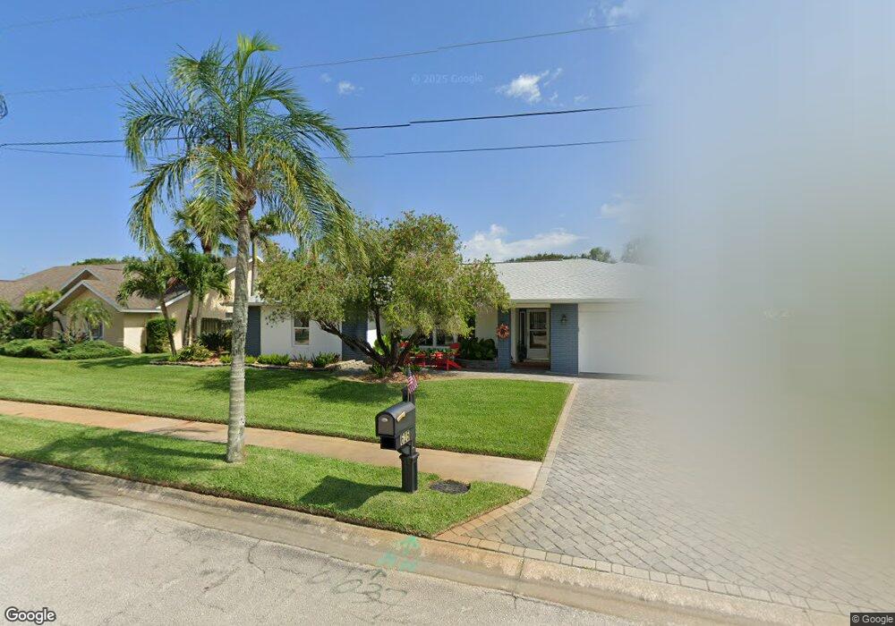
625 Anderson Ct Satellite Beach, FL 32937
Estimated Value: $740,000 - $974,000
4
Beds
3
Baths
2,086
Sq Ft
$414/Sq Ft
Est. Value
About This Home
This home is located at 625 Anderson Ct, Satellite Beach, FL 32937 and is currently estimated at $862,888, approximately $413 per square foot. 625 Anderson Ct is a home located in Brevard County with nearby schools including Spessard L. Holland Elementary School, Satellite Senior High School, and DeLaura Middle School.
Ownership History
Date
Name
Owned For
Owner Type
Purchase Details
Closed on
Aug 2, 2002
Sold by
Dimouro Paul F and Harlow Linda C
Bought by
Dimouro Paul F and Harlow Linda C
Current Estimated Value
Home Financials for this Owner
Home Financials are based on the most recent Mortgage that was taken out on this home.
Original Mortgage
$175,000
Outstanding Balance
$73,945
Interest Rate
6.53%
Mortgage Type
New Conventional
Estimated Equity
$788,943
Create a Home Valuation Report for This Property
The Home Valuation Report is an in-depth analysis detailing your home's value as well as a comparison with similar homes in the area
Home Values in the Area
Average Home Value in this Area
Purchase History
We collect this data history from publicly available records. To have your information removed, we recommend requesting removal directly through your county’s website.
| Date | Buyer | Sale Price | Title Company |
|---|---|---|---|
| Dimouro Paul F | -- | -- |
Source: Public Records
Mortgage History
We collect this data history from publicly available records. To have your information removed, we recommend requesting removal directly through your county’s website.
| Date | Status | Borrower | Loan Amount |
|---|---|---|---|
| Open | Dimouro Paul F | $175,000 |
Source: Public Records
Tax History
| Year | Tax Paid | Tax Assessment Tax Assessment Total Assessment is a certain percentage of the fair market value that is determined by local assessors to be the total taxable value of land and additions on the property. | Land | Improvement |
|---|---|---|---|---|
| 2025 | $5,240 | $323,650 | -- | -- |
| 2024 | $5,173 | $314,530 | -- | -- |
| 2023 | $5,173 | $305,370 | $0 | $0 |
| 2022 | $4,868 | $296,480 | $0 | $0 |
| 2021 | $5,046 | $287,850 | $0 | $0 |
| 2020 | $5,037 | $283,880 | $0 | $0 |
| 2019 | $5,016 | $277,500 | $0 | $0 |
| 2018 | $5,031 | $272,330 | $0 | $0 |
| 2017 | $4,796 | $266,730 | $0 | $0 |
| 2016 | $4,822 | $261,250 | $190,000 | $71,250 |
| 2015 | $4,944 | $259,440 | $190,000 | $69,440 |
| 2014 | $4,957 | $257,390 | $166,250 | $91,140 |
Source: Public Records
Map
Nearby Homes
- 669 S Hedgecock Square
- 77 Emerald Ct
- 107 Mar Brisa Ct Unit U-107
- 565 Jackson Ave
- 702 Mar Brisa Ct Unit U702
- 52 Tortuga Trail
- 61 Tortuga Trail
- 59 Tortuga Trail
- 50 Tortuga Trail
- 57 Tortuga Trail
- 55 Tortuga Trail
- 53 Tortuga Trail
- 51 Tortuga Trail
- 49 Tortuga Trail
- 47 Tortuga Trail
- 37 Tortuga Trail
- 85 Village St
- 33 Tortuga Trail
- 31 Tortuga Trail
- 11 Fillmore Ct
Your Personal Tour Guide
Ask me questions while you tour the home.