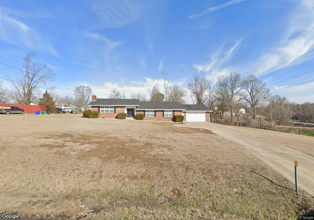
625 N E St Rogers, AR 72756
Estimated Value: $429,000 - $515,000
3
Beds
2
Baths
2,044
Sq Ft
$227/Sq Ft
Est. Value
About This Home
This home is located at 625 N E St, Rogers, AR 72756 and is currently estimated at $463,274, approximately $226 per square foot. 625 N E St is a home located in Benton County with nearby schools including Frank Tillery Elementary School, Lingle Middle School, and Rogers Heritage High School.
Ownership History
Date
Name
Owned For
Owner Type
Purchase Details
Closed on
Oct 1, 2024
Sold by
625 North E Llc
Bought by
Djk Investments Inc Retirement Plan Trust and Cook
Current Estimated Value
Purchase Details
Closed on
Dec 14, 2022
Sold by
Kolosik Aron and Kolosik Ayla J
Bought by
625 North E Llc
Purchase Details
Closed on
Nov 12, 2004
Bought by
Roller
Purchase Details
Closed on
Feb 28, 1995
Bought by
Dod 02-28-1995
Purchase Details
Closed on
Aug 7, 1978
Bought by
Flynn
Create a Home Valuation Report for This Property
The Home Valuation Report is an in-depth analysis detailing your home's value as well as a comparison with similar homes in the area
Purchase History
| Date | Buyer | Sale Price | Title Company |
|---|---|---|---|
| Djk Investments Inc Retirement Plan Trust | $385,000 | None Listed On Document | |
| 625 North E Llc | -- | -- | |
| Roller | $115,000 | -- | |
| Roller | $115,000 | -- | |
| Dod 02-28-1995 | -- | -- | |
| Flynn | $69,000 | -- |
Source: Public Records
Tax History
| Year | Tax Paid | Tax Assessment Tax Assessment Total Assessment is a certain percentage of the fair market value that is determined by local assessors to be the total taxable value of land and additions on the property. | Land | Improvement |
|---|---|---|---|---|
| 2025 | $3,929 | $72,471 | $8,000 | $64,471 |
| 2024 | $2,421 | $72,471 | $8,000 | $64,471 |
| 2023 | $2,201 | $45,420 | $8,000 | $37,420 |
| 2022 | $2,113 | $45,420 | $8,000 | $37,420 |
| 2021 | $1,932 | $45,420 | $8,000 | $37,420 |
| 2020 | $1,757 | $32,010 | $4,000 | $28,010 |
| 2019 | $1,757 | $32,010 | $4,000 | $28,010 |
| 2018 | $1,757 | $32,010 | $4,000 | $28,010 |
| 2017 | $1,554 | $32,010 | $4,000 | $28,010 |
| 2016 | $1,554 | $32,010 | $4,000 | $28,010 |
| 2015 | $1,437 | $27,160 | $3,200 | $23,960 |
| 2014 | $1,437 | $27,160 | $3,200 | $23,960 |
Source: Public Records
Map
Nearby Homes
- 418,420,422,424 N F St
- 508 E Spruce St
- 220 N C St
- 509 E Walnut St
- 516 E Pearl St
- 511 Spring St
- 0 E Spring St
- 615 & 615 1/2 N 3rd St
- 615 N 3rd St
- 814 Summit Loop
- 1.47 Acres E Allen St
- 832 Atalanta Dr
- 1409 N Arkansas St
- 832 E Hilltop Dr
- 403 6th St
- 718 W Maple St
- 0 E Hilltop Dr
- 803 S 1st St
- 0 N Hilltop Cir
- 510 N 8th St
- 0 12e Hwy Unit 441032
- 0 12e Hwy Unit 561860
- 0 #5 Hwy 12e Rd
- 11 Park
- 5 Hwy 12 E Off
- 5AC E Prairie Creek Dr
- 603 Hwy 12
- 613 Hwy 12
- 606 E Locust St
- 602 E Locust St
- 607 E Locust St
- 613 E Locust St
- 429 E Locust St
- 627 N E St
- 3 E Sky Mountain Dr
- 9 E Sky Mountain Dr
- 00 E Hwy 12 E
- 10Ac E Hwy 12 Rd
- 46.6Ac E Hwy 12
- 602 Old Hwy 12 Off
Your Personal Tour Guide
Ask me questions while you tour the home.