
Seller's Agent in 2012
John Howard
High Country Realty Professionals
(541) 910-2015
128 Total Sales


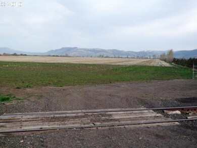


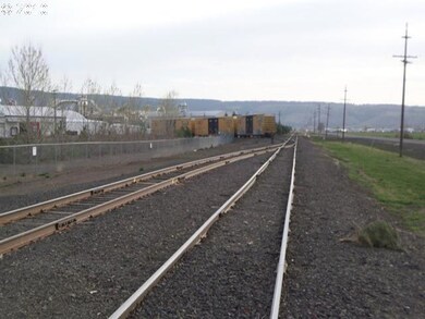
60 acre Industrial land for sale in the Baum Industrial Park in Union County with utilities in the site. Property offers easy access and boarders the Rail Spur line. Property is located approximately 4 miles from the I-84 Freeway. Call today for additional information for the Industrial land.
Last Agent to Sell the Property
High Country Realty Professionals License #910200210 Listed on: 04/19/2010
Last Buyer's Agent
High Country Realty Professionals License #910200210 Listed on: 04/19/2010
Property Type
Est. Annual Taxes
Year Built
Lot Details
Property Views
Schools
Listing and Financial Details
| Date | Buyer | Sale Price | Title Company |
|---|---|---|---|
| Kodgarshay Llc | -- | Steven J Joseph Pc | |
| Baker Samuel W | -- | None Available |
| Date | Event | Price | Change | Sq Ft Price |
|---|---|---|---|---|
| 12/27/2012 12/27/12 | Sold | $745,000 | -27.0% | -- |
| 02/13/2012 02/13/12 | Pending | -- | -- | -- |
| 04/17/2010 04/17/10 | For Sale | $1,020,000 | -- | -- |
| Year | Tax Paid | Tax Assessment Tax Assessment Total Assessment is a certain percentage of the fair market value that is determined by local assessors to be the total taxable value of land and additions on the property. | Land | Improvement |
|---|---|---|---|---|
| 2024 | $7,669 | $658,480 | $119,360 | $539,120 |
| 2023 | $8,014 | $675,730 | $119,360 | $556,370 |
| 2022 | $7,645 | $642,260 | $119,360 | $522,900 |
| 2021 | $6,884 | $574,770 | $112,230 | $462,540 |
| 2020 | $6,829 | $580,390 | $112,230 | $468,160 |
| 2019 | $7,212 | $605,030 | $112,230 | $492,800 |
Seller's Agent in 2012
John Howard
High Country Realty Professionals
(541) 910-2015
128 Total Sales
Source: Regional Multiple Listing Service (RMLS)
MLS Number: 10033219
APN: 02S3835AA 100
Disclaimer: Certain information contained herein is derived from information provided by parties other than Homes.com. All information provided is deemed reliable, but is not guaranteed to be accurate and should be independently verified.
![]() The content relating to real estate for sale on this web site comes in part from the IDX program of the RMLS™ of Portland, Oregon. Real estate listings held by brokerage firms other than Ten-X are marked with the RMLS™ logo, and detailed information about these properties includes the names of the listing brokers. Listing content is copyright © 2025 RMLS™, Portland, Oregon. Some properties which appear for sale on this web site may subsequently have sold or may no longer be available. All information provided is deemed reliable but is not guaranteed and should be independently verified.
The content relating to real estate for sale on this web site comes in part from the IDX program of the RMLS™ of Portland, Oregon. Real estate listings held by brokerage firms other than Ten-X are marked with the RMLS™ logo, and detailed information about these properties includes the names of the listing brokers. Listing content is copyright © 2025 RMLS™, Portland, Oregon. Some properties which appear for sale on this web site may subsequently have sold or may no longer be available. All information provided is deemed reliable but is not guaranteed and should be independently verified.