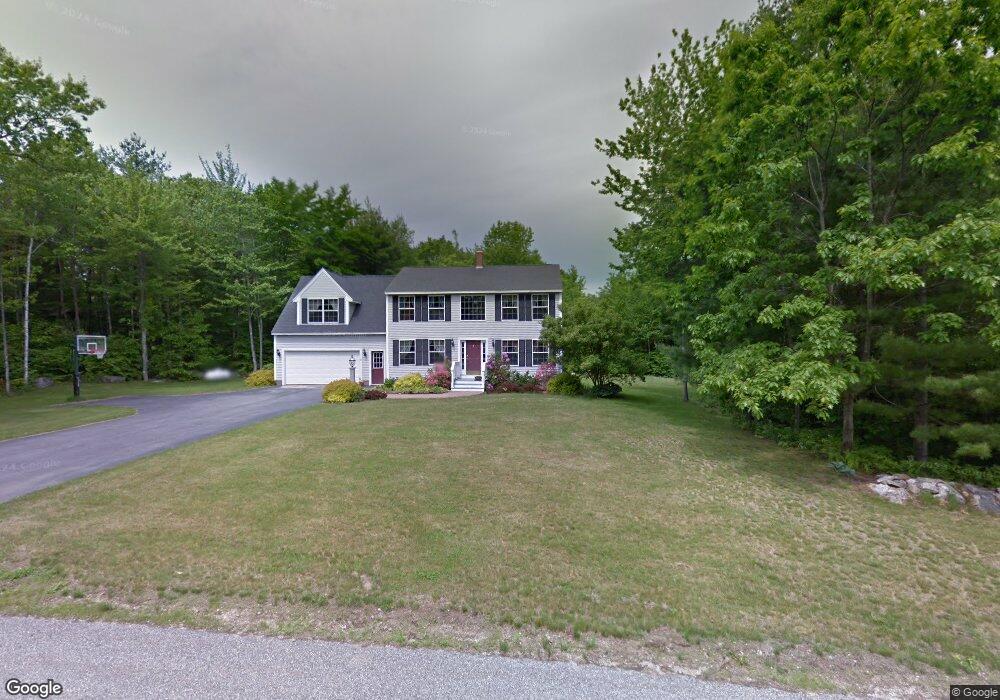
63 Dermot Dr New Gloucester, ME 04260
Estimated Value: $377,000 - $476,000
3
Beds
2
Baths
1,740
Sq Ft
$241/Sq Ft
Est. Value
About This Home
This home is located at 63 Dermot Dr, New Gloucester, ME 04260 and is currently estimated at $419,011, approximately $240 per square foot. 63 Dermot Dr is a home located in Cumberland County with nearby schools including Gray-New Gloucester High School.
Ownership History
Date
Name
Owned For
Owner Type
Purchase Details
Closed on
Feb 25, 2014
Sold by
Davis Andrew J and Davis Stefanie A
Bought by
Bernier Ryan
Current Estimated Value
Home Financials for this Owner
Home Financials are based on the most recent Mortgage that was taken out on this home.
Original Mortgage
$188,265
Outstanding Balance
$142,309
Interest Rate
4.5%
Mortgage Type
New Conventional
Estimated Equity
$276,702
Purchase Details
Closed on
May 14, 2008
Sold by
Davis Andrew J
Bought by
Davis Andrew J and Davis Stefanie A
Home Financials for this Owner
Home Financials are based on the most recent Mortgage that was taken out on this home.
Original Mortgage
$192,850
Interest Rate
5.91%
Mortgage Type
FHA
Create a Home Valuation Report for This Property
The Home Valuation Report is an in-depth analysis detailing your home's value as well as a comparison with similar homes in the area
Home Values in the Area
Average Home Value in this Area
Purchase History
| Date | Buyer | Sale Price | Title Company |
|---|---|---|---|
| Bernier Ryan | -- | -- | |
| Davis Andrew J | -- | -- |
Source: Public Records
Mortgage History
| Date | Status | Borrower | Loan Amount |
|---|---|---|---|
| Open | Bernier Ryan | $188,265 | |
| Previous Owner | Davis Andrew J | $192,850 |
Source: Public Records
Tax History Compared to Growth
Tax History
| Year | Tax Paid | Tax Assessment Tax Assessment Total Assessment is a certain percentage of the fair market value that is determined by local assessors to be the total taxable value of land and additions on the property. | Land | Improvement |
|---|---|---|---|---|
| 2025 | $3,382 | $218,625 | $84,099 | $134,526 |
| 2024 | $3,255 | $218,625 | $84,099 | $134,526 |
| 2023 | $3,124 | $218,625 | $84,099 | $134,526 |
| 2022 | $3,017 | $218,625 | $84,099 | $134,526 |
| 2021 | $3,017 | $218,625 | $84,099 | $134,526 |
| 2020 | $2,984 | $218,625 | $84,099 | $134,526 |
| 2019 | $2,716 | $160,700 | $65,800 | $94,900 |
| 2018 | $2,539 | $160,700 | $65,800 | $94,900 |
| 2017 | $2,507 | $160,700 | $65,800 | $94,900 |
| 2016 | $2,362 | $160,700 | $65,800 | $94,900 |
| 2015 | $2,354 | $160,700 | $65,800 | $94,900 |
| 2014 | $2,330 | $160,700 | $65,800 | $94,900 |
| 2013 | $2,161 | $160,700 | $65,800 | $94,900 |
Source: Public Records
Map
Nearby Homes
- 423 Sabbathday Rd
- 14 Golden Way
- 24 Swamp Rd
- TBD Targett Rd
- 271 Bennett Rd
- 00 N Shore Rd
- 22 Shaw Rd
- 343 Shaker Rd
- 4 Chelsey Ln
- 15 May Meadow Dr
- 74 May Meadow Dr
- 148 Spiller Hill Rd
- 155 & 151 Gloucester Hill Rd
- 161 Beaver Dam Dr
- 160 Gloucester Hill Rd
- 157 Egypt Rd
- 26 Carpenter Rd
- 21 Westwood Rd
- 164 Intervale Rd
- 13 Mill Brook Rd Unit A
- Lot C Dermot Dr
- 57 Dermot Dr
- 39 Dermot Dr
- 58 Dermot Dr
- 42 Dermot Dr
- 0 Dermot Rd
- 29 Dermot Dr
- 26 Dermot Dr
- 0 Maine 26
- 328B Sabbathday Rd
- 328A Sabbathday Rd
- 15 Dermot Dr
- 326 Sabbathday Rd
- 0 Main Street Rt 26 Unit 1454736
- 8 Hamilton Dr Unit Lot 3
- 10 Hamilton Dr Unit Lot 4
- 18 Dermot Dr
- 6 Hamilton Dr
- 6 Hamilton Dr Unit Lot 2
- 14 Hamilton Dr Unit Lot 5