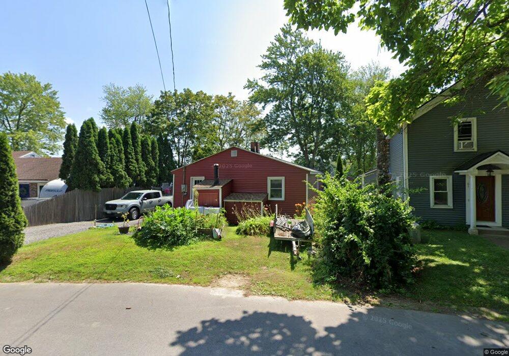
63 Flint Pond Dr Hollis, NH 03049
Hollis NeighborhoodEstimated Value: $308,000 - $528,000
3
Beds
1
Bath
984
Sq Ft
$432/Sq Ft
Est. Value
About This Home
This home is located at 63 Flint Pond Dr, Hollis, NH 03049 and is currently estimated at $424,721, approximately $431 per square foot. 63 Flint Pond Dr is a home with nearby schools including Hollis Primary School, Hollis Upper Elementary School, and Hollis-Brookline Middle School.
Ownership History
Date
Name
Owned For
Owner Type
Purchase Details
Closed on
Feb 5, 2021
Sold by
Sprague George R and Sprague-Galvin Debra
Bought by
G & D Sprague Prop Llc
Current Estimated Value
Purchase Details
Closed on
Mar 13, 2009
Sold by
Williams Adam J
Bought by
Robert E Cole Ret and Cole
Purchase Details
Closed on
Jul 28, 2003
Sold by
Taylor Stacey N
Bought by
Wisbey Sean N
Purchase Details
Closed on
Mar 15, 2002
Sold by
Keyworth H William H and Keyworth Beth G
Bought by
Taylor Stacey N
Purchase Details
Closed on
Apr 13, 1998
Sold by
Concannon Timothy
Bought by
Keyworth H William H and Keyworth Beth G
Create a Home Valuation Report for This Property
The Home Valuation Report is an in-depth analysis detailing your home's value as well as a comparison with similar homes in the area
Home Values in the Area
Average Home Value in this Area
Purchase History
| Date | Buyer | Sale Price | Title Company |
|---|---|---|---|
| G & D Sprague Prop Llc | -- | None Available | |
| G & D Sprague Prop Llc | -- | None Available | |
| Robert E Cole Ret | $255,000 | -- | |
| Robert E Cole Ret | $255,000 | -- | |
| Wisbey Sean N | $170,000 | -- | |
| Wisbey Sean N | $170,000 | -- | |
| Taylor Stacey N | $124,000 | -- | |
| Taylor Stacey N | $124,000 | -- | |
| Keyworth H William H | $71,600 | -- | |
| Keyworth H William H | $71,600 | -- |
Source: Public Records
Mortgage History
| Date | Status | Borrower | Loan Amount |
|---|---|---|---|
| Previous Owner | Keyworth H William H | $176,000 | |
| Previous Owner | Keyworth H William H | $44,000 |
Source: Public Records
Tax History Compared to Growth
Tax History
| Year | Tax Paid | Tax Assessment Tax Assessment Total Assessment is a certain percentage of the fair market value that is determined by local assessors to be the total taxable value of land and additions on the property. | Land | Improvement |
|---|---|---|---|---|
| 2024 | $6,200 | $349,700 | $205,200 | $144,500 |
| 2023 | $5,826 | $349,700 | $205,200 | $144,500 |
| 2022 | $7,893 | $349,700 | $205,200 | $144,500 |
| 2021 | $4,184 | $184,300 | $105,300 | $79,000 |
| 2020 | $5,842 | $184,300 | $105,300 | $79,000 |
| 2019 | $5,367 | $184,300 | $105,300 | $79,000 |
| 2018 | $3,994 | $184,300 | $105,300 | $79,000 |
| 2017 | $3,584 | $154,800 | $86,900 | $67,900 |
| 2016 | $5,132 | $154,800 | $86,900 | $67,900 |
| 2015 | $3,563 | $154,800 | $86,900 | $67,900 |
| 2014 | $3,581 | $154,800 | $86,900 | $67,900 |
| 2013 | $3,533 | $154,800 | $86,900 | $67,900 |
Source: Public Records
Map
Nearby Homes
- 199 Pine Hill Rd
- 118 Broad St
- 334 Broad St
- 40-40A Pine Hill Rd
- 77 Broad St
- 11 Rideout Rd
- 95 Wright Rd
- 28 Bartemus Trail Unit U210
- 76 Bartemus Trail Unit U231
- 22 Cathedral Cir
- 11 Bartemus Trail Unit 204
- 7 Lovejoy Ln
- 6 Cornwall Ln Unit 7
- 14 Parrish Hill Dr
- 20 Martha St
- 5 Plainfield Ln
- 3 Richmond St
- 4 Nelson St
- 46 Scenic Dr
- 5 Meghan Dr Unit U23
- 65 Flint Pond Dr
- 61 Flint Pond Dr
- 59 Flint Pond Dr
- 60 Flint Pond Dr
- 69 Flint Pond Dr
- 62 Flint Pond Dr
- 56 Flint Pond Dr
- 64 Flint Pond Dr
- 71 Flint Pond Dr
- 66 Flint Pond Dr
- 57 Flint Pond Dr
- 73 Flint Pond Dr
- 52 Flint Pond Dr
- 55 Flint Pond Dr
- 53 Flint Pond Dr
- 68 Flint Pond Dr
- 68R Flint Pond Dr
- 50 Flint Pond Dr
- 68RR Flint Pond Dr
- 70 Flint Pond Dr