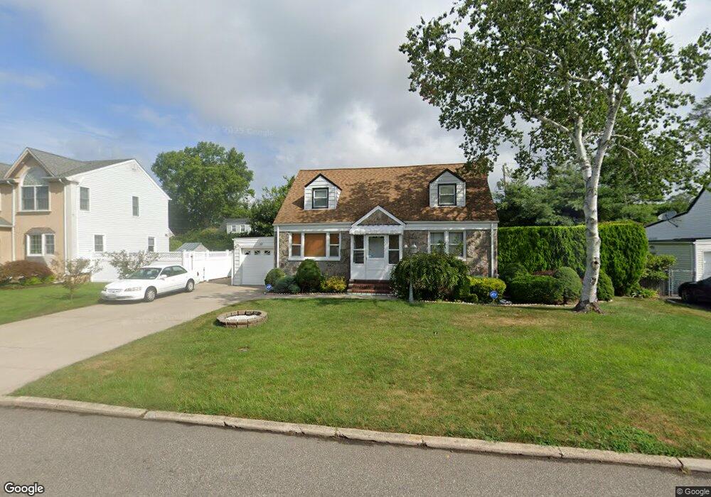
63 May Ave Westbury, NY 11590
Estimated Value: $742,000 - $802,567
4
Beds
3
Baths
1,683
Sq Ft
$459/Sq Ft
Est. Value
About This Home
This home is located at 63 May Ave, Westbury, NY 11590 and is currently estimated at $772,284, approximately $458 per square foot. 63 May Ave is a home located in Nassau County with nearby schools including Westbury Middle School, Westbury High School, and St Brigid/Our Lady Of Hope Regional School.
Ownership History
Date
Name
Owned For
Owner Type
Purchase Details
Closed on
Oct 19, 2022
Sold by
Ahsan Muhamad Faraz and Ahsan Muhammad Imtiaz
Bought by
Ahsan Muhamad Faraz
Current Estimated Value
Purchase Details
Closed on
Feb 16, 2016
Sold by
Carrillo Fabiola and Carrillo Jorge
Bought by
Ahsan Muhammed Faraz and Ahsan Muhammed Imtiaz
Home Financials for this Owner
Home Financials are based on the most recent Mortgage that was taken out on this home.
Original Mortgage
$439,814
Outstanding Balance
$348,318
Interest Rate
3.75%
Mortgage Type
FHA
Estimated Equity
$423,966
Create a Home Valuation Report for This Property
The Home Valuation Report is an in-depth analysis detailing your home's value as well as a comparison with similar homes in the area
Home Values in the Area
Average Home Value in this Area
Purchase History
| Date | Buyer | Sale Price | Title Company |
|---|---|---|---|
| Ahsan Muhamad Faraz | -- | None Available | |
| Ahsan Muhammed Faraz | $455,000 | Judicial Title |
Source: Public Records
Mortgage History
| Date | Status | Borrower | Loan Amount |
|---|---|---|---|
| Open | Ahsan Muhammed Faraz | $439,814 |
Source: Public Records
Tax History Compared to Growth
Tax History
| Year | Tax Paid | Tax Assessment Tax Assessment Total Assessment is a certain percentage of the fair market value that is determined by local assessors to be the total taxable value of land and additions on the property. | Land | Improvement |
|---|---|---|---|---|
| 2025 | $13,920 | $478 | $222 | $256 |
| 2024 | $2,793 | $487 | $227 | $260 |
| 2023 | $14,831 | $520 | $242 | $278 |
| 2022 | $14,831 | $520 | $242 | $278 |
| 2021 | $14,409 | $500 | $233 | $267 |
| 2020 | $13,288 | $696 | $512 | $184 |
| 2019 | $12,041 | $696 | $512 | $184 |
| 2018 | $12,041 | $696 | $0 | $0 |
| 2017 | $7,943 | $696 | $512 | $184 |
| 2016 | $10,074 | $696 | $512 | $184 |
| 2015 | $2,047 | $696 | $512 | $184 |
| 2014 | $2,047 | $696 | $512 | $184 |
| 2013 | $1,934 | $696 | $512 | $184 |
Source: Public Records
Map
Nearby Homes
- 64 Wilson Ave
- 355 Sylvan Ln
- 333 Sylvan Ln
- 330 Ellison Ave
- 198 Belmont Ave
- 24 Walnut St
- 31 Chestnut St
- 213 Belmont Ave
- 246 Liberty Ave
- 205 Schenck Ave
- 45 Manchester St
- 175 Maple Ave Unit 5G
- 68 Oriole Way
- 194 Rhododendron Dr
- 324 Post Ave Unit 6E
- 324 Post Ave Unit . 8-J
- 324 Post Ave Unit 5-J
- 266 Park Ave W
- 242 Maple Ave Unit 501
- 242 Maple Ave Unit 513