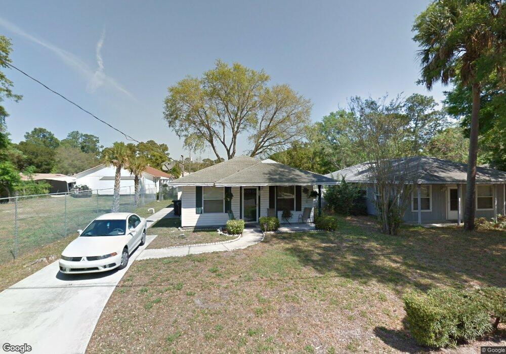
63 Robert St Atlantic Beach, FL 32233
Estimated Value: $321,214 - $455,000
3
Beds
3
Baths
1,120
Sq Ft
$336/Sq Ft
Est. Value
About This Home
This home is located at 63 Robert St, Atlantic Beach, FL 32233 and is currently estimated at $375,804, approximately $335 per square foot. 63 Robert St is a home located in Duval County with nearby schools including Neptune Beach Elementary School, Mayport Middle School, and Duncan U. Fletcher High School.
Ownership History
Date
Name
Owned For
Owner Type
Purchase Details
Closed on
May 21, 2001
Sold by
Lyles Tommy and Lyles Shirley
Bought by
D & L Enterprises Llc
Current Estimated Value
Purchase Details
Closed on
Jun 26, 1998
Sold by
Habitat For Humanity Of The Jacksonville
Bought by
Turner Clara Mae
Home Financials for this Owner
Home Financials are based on the most recent Mortgage that was taken out on this home.
Original Mortgage
$53,740
Interest Rate
7.1%
Mortgage Type
Seller Take Back
Create a Home Valuation Report for This Property
The Home Valuation Report is an in-depth analysis detailing your home's value as well as a comparison with similar homes in the area
Home Values in the Area
Average Home Value in this Area
Purchase History
| Date | Buyer | Sale Price | Title Company |
|---|---|---|---|
| D & L Enterprises Llc | $25,000 | -- | |
| Turner Clara Mae | $42,900 | -- |
Source: Public Records
Mortgage History
| Date | Status | Borrower | Loan Amount |
|---|---|---|---|
| Previous Owner | Turner Clara Mae | $53,740 |
Source: Public Records
Tax History
| Year | Tax Paid | Tax Assessment Tax Assessment Total Assessment is a certain percentage of the fair market value that is determined by local assessors to be the total taxable value of land and additions on the property. | Land | Improvement |
|---|---|---|---|---|
| 2026 | $551 | $69,072 | -- | -- |
| 2025 | $544 | $69,072 | -- | -- |
| 2024 | $535 | $67,126 | -- | -- |
| 2023 | $535 | $65,171 | $0 | $0 |
| 2022 | $494 | $63,273 | $0 | $0 |
| 2021 | $502 | $61,431 | $0 | $0 |
| 2020 | $501 | $60,583 | $0 | $0 |
| 2019 | $502 | $59,221 | $0 | $0 |
| 2018 | $500 | $58,117 | $0 | $0 |
| 2017 | $610 | $33,600 | $33,600 | $0 |
| 2016 | $502 | $55,752 | $0 | $0 |
| 2015 | $511 | $55,365 | $0 | $0 |
| 2014 | $514 | $54,926 | $0 | $0 |
Source: Public Records
Map
Nearby Homes
- 1879 George St
- 1931 Francis Ave
- 1673 Linkside Ct N
- 974 Calypso Way
- 66 W 14th St
- 831 Bonita Rd
- 0 West Plaza
- 1524 Linkside Dr
- 599 Timber Bridge Ln
- 568 Timber Bridge Ln
- 569 Timber Bridge Ln
- 0 Dutton Island Rd W
- 1109 Hibiscus St
- 1255-1285 Hibiscus St
- 2273 Fairway Villas Dr
- 951 Paradise Cir
- 1193 Linkside Ct E
- 1732 Atlantic Beach Dr
- 2135 Fairway Villas Dr
- 2153 Fairway Villas Dr
Your Personal Tour Guide
Ask me questions while you tour the home.