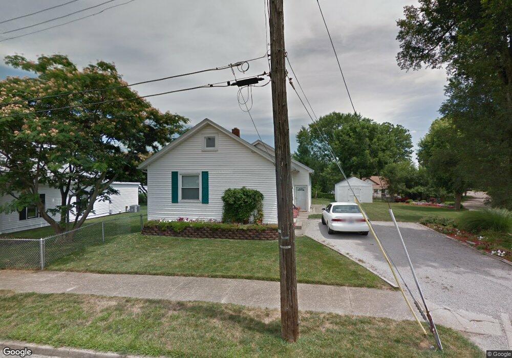
630 Barnard Ave Hamilton, OH 45013
Estimated Value: $121,000 - $164,000
2
Beds
1
Bath
1,180
Sq Ft
$117/Sq Ft
Est. Value
About This Home
This home is located at 630 Barnard Ave, Hamilton, OH 45013 and is currently estimated at $138,579, approximately $117 per square foot. 630 Barnard Ave is a home located in Butler County with nearby schools including Highland Elementary School, Wilson Middle School, and Hamilton High School Main Campus.
Ownership History
Date
Name
Owned For
Owner Type
Purchase Details
Closed on
Jul 8, 2005
Sold by
Miller Maureen M and Miller Jennifer Faye
Bought by
Miller Maureen M
Current Estimated Value
Home Financials for this Owner
Home Financials are based on the most recent Mortgage that was taken out on this home.
Original Mortgage
$60,000
Outstanding Balance
$30,781
Interest Rate
5.69%
Mortgage Type
Stand Alone Refi Refinance Of Original Loan
Estimated Equity
$107,798
Purchase Details
Closed on
Aug 1, 1987
Create a Home Valuation Report for This Property
The Home Valuation Report is an in-depth analysis detailing your home's value as well as a comparison with similar homes in the area
Home Values in the Area
Average Home Value in this Area
Purchase History
| Date | Buyer | Sale Price | Title Company |
|---|---|---|---|
| Miller Maureen M | -- | -- | |
| -- | $35,400 | -- |
Source: Public Records
Mortgage History
| Date | Status | Borrower | Loan Amount |
|---|---|---|---|
| Open | Miller Maureen M | $60,000 |
Source: Public Records
Tax History
| Year | Tax Paid | Tax Assessment Tax Assessment Total Assessment is a certain percentage of the fair market value that is determined by local assessors to be the total taxable value of land and additions on the property. | Land | Improvement |
|---|---|---|---|---|
| 2025 | $1,029 | $24,370 | $2,670 | $21,700 |
| 2024 | $1,029 | $24,370 | $2,670 | $21,700 |
| 2023 | $1,024 | $24,370 | $2,670 | $21,700 |
| 2022 | $853 | $17,040 | $2,670 | $14,370 |
| 2021 | $745 | $16,430 | $2,670 | $13,760 |
| 2020 | $776 | $16,430 | $2,670 | $13,760 |
| 2019 | $1,275 | $17,420 | $5,020 | $12,400 |
| 2018 | $811 | $17,420 | $5,020 | $12,400 |
| 2017 | $818 | $17,420 | $5,020 | $12,400 |
| 2016 | $803 | $16,300 | $5,020 | $11,280 |
| 2015 | $799 | $16,300 | $5,020 | $11,280 |
| 2014 | $770 | $16,300 | $5,020 | $11,280 |
| 2013 | $770 | $16,290 | $5,020 | $11,270 |
Source: Public Records
Map
Nearby Homes
- 315 Millville Ave
- 1044 Hunt Ave
- 1131 Azel Ave
- 346 Hyde Park Dr
- 1116 Azel Ave
- 1326 Franklin St
- 609 Coralie St
- 732 Millville Ave
- 905 Virginia Ave
- 618 Main St
- 760 Park Ave
- 30 S Washington Blvd
- 422 S G St
- 1263 Park Ave
- 504 Ridgewood Ave
- 214 Sherman Ave
- 444 N Dick Ave
- 900 N Lawn Ave
- 201 Progress Ave
- 974 Westview Ave
- 626 Barnard Ave
- 631 S Mckinley Ave
- 637 S Mckinley Ave
- 629 S Mckinley Ave
- 618 Barnard Ave
- 639 S Mckinley Ave
- 627 Barnard Ave
- 625 S Mckinley Ave
- 623 Barnard Ave
- 616 Barnard Ave
- 623 S Mckinley Ave
- 621 Barnard Ave
- 614 Barnard Ave
- 621 S Mckinley Ave
- 617 S Mckinley Ave
- 612 Barnard Ave
- 615 Barnard Ave
- 636 S Mckinley Ave
- 630 S Mckinley Ave
- 644 Kenworth Ave
Your Personal Tour Guide
Ask me questions while you tour the home.