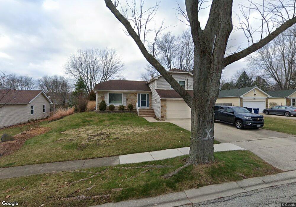
630 Chestnut Ct Algonquin, IL 60102
High Hill Farms NeighborhoodEstimated Value: $372,777 - $440,000
3
Beds
2
Baths
2,466
Sq Ft
$163/Sq Ft
Est. Value
About This Home
This home is located at 630 Chestnut Ct, Algonquin, IL 60102 and is currently estimated at $402,444, approximately $163 per square foot. 630 Chestnut Ct is a home located in McHenry County with nearby schools including Westfield Community School, Kenneth E Neubert Elementary School, and Harry D Jacobs High School.
Ownership History
Date
Name
Owned For
Owner Type
Purchase Details
Closed on
Apr 21, 2005
Sold by
Denicolo Theresa A
Bought by
Denicolo Theresa A and Theresa A Denicolo Trust
Current Estimated Value
Purchase Details
Closed on
Feb 26, 2004
Sold by
Gleason Diane K
Bought by
Denicolo Theresa Ann
Purchase Details
Closed on
Jun 22, 1995
Sold by
Gleason Byron E
Bought by
Gleason Diane K
Create a Home Valuation Report for This Property
The Home Valuation Report is an in-depth analysis detailing your home's value as well as a comparison with similar homes in the area
Home Values in the Area
Average Home Value in this Area
Purchase History
| Date | Buyer | Sale Price | Title Company |
|---|---|---|---|
| Denicolo Theresa A | -- | -- | |
| Denicolo Theresa Ann | $220,000 | Universal Title Services Inc | |
| Gleason Diane K | -- | -- |
Source: Public Records
Tax History
| Year | Tax Paid | Tax Assessment Tax Assessment Total Assessment is a certain percentage of the fair market value that is determined by local assessors to be the total taxable value of land and additions on the property. | Land | Improvement |
|---|---|---|---|---|
| 2024 | $3,974 | $109,726 | $23,309 | $86,417 |
| 2023 | $6,876 | $98,136 | $20,847 | $77,289 |
| 2022 | $4,785 | $89,241 | $21,044 | $68,197 |
| 2021 | $4,951 | $83,139 | $19,605 | $63,534 |
| 2020 | $5,010 | $80,196 | $18,911 | $61,285 |
| 2019 | $5,124 | $76,757 | $18,100 | $58,657 |
| 2018 | $5,319 | $70,908 | $16,721 | $54,187 |
| 2017 | $6,054 | $66,800 | $15,752 | $51,048 |
| 2016 | $5,957 | $62,652 | $14,774 | $47,878 |
| 2013 | -- | $56,229 | $13,783 | $42,446 |
Source: Public Records
Map
Nearby Homes
- 615 Harper Dr
- 313 Bayberry Dr
- 21 Division St
- 407 La Fox River Dr
- 108 La Fox Dr
- 909 Roger St
- 1354 Essex St Unit 2
- 0 River Dr N Unit MRD12473279
- 1200 Hillside View
- 1431 Essex St
- SWC Talaga and Algonquin Rd
- 1 Grandview Ct Unit 8
- 935 Viewpoint Dr
- 700 Fairfield Ln
- 944 Cynthia Ln
- Lot #3-5 Hayes Rd
- 298 Apache Trail
- LOT 3 Blackhawk Dr
- 1096 Viewpoint Dr
- 600 E Algonquin Rd
- 620 Chestnut Ct
- 640 Chestnut Ct
- 641 Butterfield Dr
- 651 Butterfield Dr
- 631 Butterfield Dr
- 625 Chestnut Ct
- 650 Chestnut Ct Unit 1
- 610 Chestnut Ct
- 635 Chestnut Ct
- 615 Chestnut Ct
- 661 Butterfield Dr
- 621 Butterfield Dr
- 645 Chestnut Ct
- 605 Chestnut Ct
- 600 Chestnut Ct Unit 2
- 612 Orchard Ct
- 611 Butterfield Dr
- 622 Orchard Ct
- 650 Butterfield Dr
- 660 Butterfield Dr
Your Personal Tour Guide
Ask me questions while you tour the home.