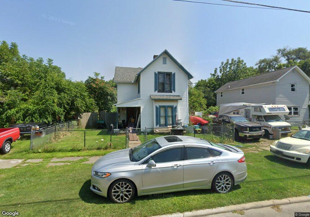
630 Lee St Marion, OH 43302
Estimated Value: $79,000 - $96,060
5
Beds
1
Bath
1,040
Sq Ft
$83/Sq Ft
Est. Value
About This Home
This home is located at 630 Lee St, Marion, OH 43302 and is currently estimated at $86,515, approximately $83 per square foot. 630 Lee St is a home located in Marion County with nearby schools including Rutherford B. Hayes Elementary School, Ulysses S. Grant Middle School, and Harding High School.
Ownership History
Date
Name
Owned For
Owner Type
Purchase Details
Closed on
Jun 1, 2007
Sold by
Select Portfolio Servicing Inc
Bought by
Rollison David F and Aleshire Ritakay
Current Estimated Value
Purchase Details
Closed on
Jul 24, 2006
Sold by
Russell Elmer C
Bought by
Select Portfolio Servicing Inc
Purchase Details
Closed on
Feb 2, 1998
Bought by
Rollison David F
Purchase Details
Closed on
Apr 11, 1997
Bought by
Rollison David F
Purchase Details
Closed on
Jun 21, 1995
Bought by
Rollison David F
Create a Home Valuation Report for This Property
The Home Valuation Report is an in-depth analysis detailing your home's value as well as a comparison with similar homes in the area
Home Values in the Area
Average Home Value in this Area
Purchase History
| Date | Buyer | Sale Price | Title Company |
|---|---|---|---|
| Rollison David F | $11,900 | None Available | |
| Select Portfolio Servicing Inc | $44,111 | None Available | |
| Rollison David F | $20,000 | -- | |
| Rollison David F | -- | -- | |
| Rollison David F | -- | -- |
Source: Public Records
Tax History Compared to Growth
Tax History
| Year | Tax Paid | Tax Assessment Tax Assessment Total Assessment is a certain percentage of the fair market value that is determined by local assessors to be the total taxable value of land and additions on the property. | Land | Improvement |
|---|---|---|---|---|
| 2024 | $839 | $19,320 | $2,920 | $16,400 |
| 2023 | $839 | $19,320 | $2,920 | $16,400 |
| 2022 | $633 | $19,320 | $2,920 | $16,400 |
| 2021 | $590 | $15,330 | $2,540 | $12,790 |
| 2020 | $793 | $15,330 | $2,540 | $12,790 |
| 2019 | $792 | $15,330 | $2,540 | $12,790 |
| 2018 | $671 | $12,740 | $2,490 | $10,250 |
| 2017 | $759 | $17,660 | $2,490 | $15,170 |
| 2016 | $347 | $17,660 | $2,490 | $15,170 |
| 2015 | $338 | $17,250 | $2,370 | $14,880 |
| 2014 | $804 | $17,250 | $2,370 | $14,880 |
| 2012 | $478 | $20,670 | $2,790 | $17,880 |
Source: Public Records
Map
Nearby Homes
- 523 Thompson St
- 531 Toledo Ave
- 641 Blake Ave
- 520 Toledo Ave
- 485 Avondale Ave
- 355 Lee St
- 468 Avondale Ave
- 551 Universal Ave Unit 555
- 134 Waterloo St
- 636 Mary St
- 343 Commercial St
- 178 Leader St
- 213 Sharp St
- 347 Mary St
- 233 Tully St
- 552 N Prospect St
- 736 N Main St
- 395 N Main St
- 593 N State St
- 1015 N Main St