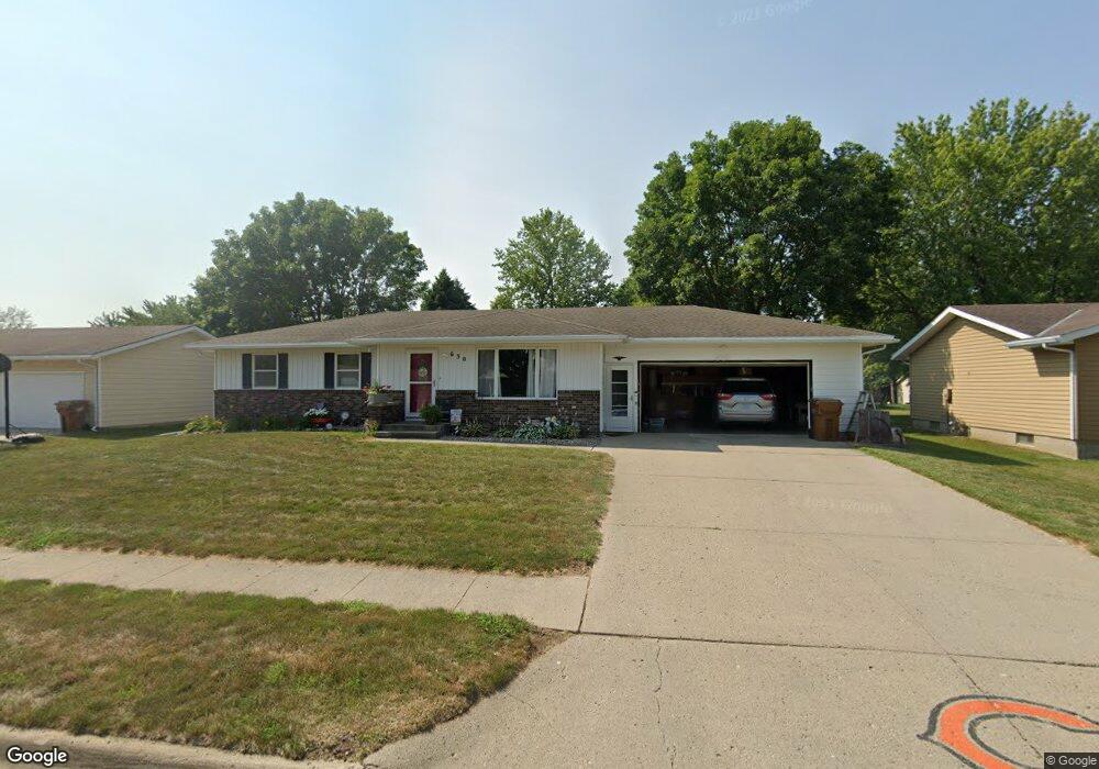
630 Mockingbird Dr Carroll, IA 51401
Estimated Value: $232,959 - $270,000
3
Beds
3
Baths
1,320
Sq Ft
$189/Sq Ft
Est. Value
About This Home
This home is located at 630 Mockingbird Dr, Carroll, IA 51401 and is currently estimated at $249,240, approximately $188 per square foot. 630 Mockingbird Dr is a home with nearby schools including Fairview Elementary School, Adams Elementary School, and Carroll Middle School.
Ownership History
Date
Name
Owned For
Owner Type
Purchase Details
Closed on
Feb 15, 2013
Sold by
Brinker Luverne H and Brinker Angela M
Bought by
Klever Alex and Klever Natasha
Current Estimated Value
Home Financials for this Owner
Home Financials are based on the most recent Mortgage that was taken out on this home.
Original Mortgage
$133,200
Interest Rate
3.46%
Mortgage Type
New Conventional
Create a Home Valuation Report for This Property
The Home Valuation Report is an in-depth analysis detailing your home's value as well as a comparison with similar homes in the area
Home Values in the Area
Average Home Value in this Area
Purchase History
| Date | Buyer | Sale Price | Title Company |
|---|---|---|---|
| Klever Alex | $148,000 | None Available |
Source: Public Records
Mortgage History
| Date | Status | Borrower | Loan Amount |
|---|---|---|---|
| Previous Owner | Klever Alex | $133,200 |
Source: Public Records
Tax History Compared to Growth
Tax History
| Year | Tax Paid | Tax Assessment Tax Assessment Total Assessment is a certain percentage of the fair market value that is determined by local assessors to be the total taxable value of land and additions on the property. | Land | Improvement |
|---|---|---|---|---|
| 2025 | $2,216 | $203,990 | $27,640 | $176,350 |
| 2024 | $2,216 | $182,910 | $27,640 | $155,270 |
| 2023 | $2,627 | $182,910 | $27,640 | $155,270 |
| 2022 | $2,490 | $180,750 | $27,640 | $153,110 |
| 2021 | $2,490 | $180,750 | $27,640 | $153,110 |
| 2020 | $2,552 | $180,750 | $27,640 | $153,110 |
| 2019 | $2,510 | $180,750 | $27,640 | $153,110 |
| 2018 | $2,360 | $180,750 | $27,640 | $153,110 |
| 2017 | $2,360 | $173,533 | $24,503 | $149,030 |
| 2016 | $2,196 | $162,180 | $0 | $0 |
| 2015 | $2,196 | $147,420 | $0 | $0 |
| 2014 | $1,962 | $147,420 | $0 | $0 |
Source: Public Records
Map
Nearby Homes
- 638 Capistrano Ave
- 621 Alta Vista Dr
- 260 Bass St
- 746 Granada Rd
- 222 Bass St
- 265 Perch St
- 1550 Edgewood Dr
- 1137 High Ridge Rd
- 1620 Edgewood Dr
- 1601 Pike Ave
- 1102 Skyline Dr
- 1068 Amy Ave
- 1022 Skyline Dr
- 1026 N Clark St
- 1217 N Main St
- 1408 N Adams St
- 1108 N Main St
- 1102 N Main St
- 926 N Court St
- 226 W 13th St
- 622 Mockingbird Dr
- 633 Mockingbird Dr
- 636 Mockingbird Dr
- 614 Mockingbird Dr
- 631 Capistrano Ave
- 623 Mockingbird Dr
- 639 Capistrano Ave
- 623 Capistrano Ave
- 703 Mockingbird Dr
- 611 Mockingbird Dr
- 712 Mockingbird Dr
- 610 Mockingbird Dr
- 703 Capistrano Ave
- 619 Capistrano Ave
- 711 Mockingbird Dr
- 606 Mockingbird Dr
- 716 Mockingbird Dr
- 605 Mockingbird Dr
- 713 Capistrano Ave
- 1506 Olive St