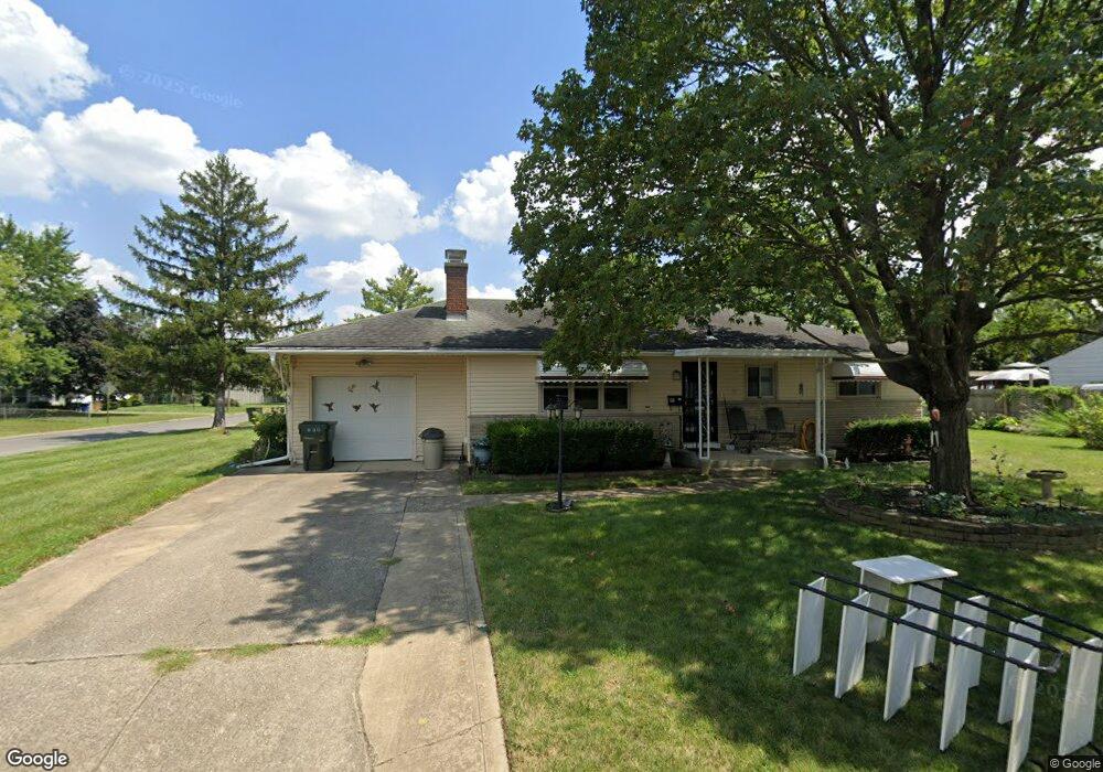
630 Powhatan Ave Columbus, OH 43204
Southwest Hilltop NeighborhoodEstimated Value: $200,586 - $250,000
3
Beds
2
Baths
1,066
Sq Ft
$209/Sq Ft
Est. Value
About This Home
This home is located at 630 Powhatan Ave, Columbus, OH 43204 and is currently estimated at $222,397, approximately $208 per square foot. 630 Powhatan Ave is a home located in Franklin County with nearby schools including Binns Elementary School, Wedgewood Middle School, and Briggs High School.
Ownership History
Date
Name
Owned For
Owner Type
Purchase Details
Closed on
Sep 19, 2008
Sold by
Bolin William E
Bought by
Beasley Allen H and Beasley Nancy J
Current Estimated Value
Purchase Details
Closed on
Jan 4, 1996
Sold by
Sanders Roy A
Bought by
William E Bolin
Home Financials for this Owner
Home Financials are based on the most recent Mortgage that was taken out on this home.
Original Mortgage
$44,300
Interest Rate
7.41%
Mortgage Type
New Conventional
Purchase Details
Closed on
Feb 1, 1993
Purchase Details
Closed on
Feb 14, 1990
Create a Home Valuation Report for This Property
The Home Valuation Report is an in-depth analysis detailing your home's value as well as a comparison with similar homes in the area
Home Values in the Area
Average Home Value in this Area
Purchase History
| Date | Buyer | Sale Price | Title Company |
|---|---|---|---|
| Beasley Allen H | $115,500 | Title First | |
| William E Bolin | $84,500 | -- | |
| -- | $71,000 | -- | |
| -- | $62,900 | -- |
Source: Public Records
Mortgage History
| Date | Status | Borrower | Loan Amount |
|---|---|---|---|
| Previous Owner | William E Bolin | $44,300 |
Source: Public Records
Tax History Compared to Growth
Tax History
| Year | Tax Paid | Tax Assessment Tax Assessment Total Assessment is a certain percentage of the fair market value that is determined by local assessors to be the total taxable value of land and additions on the property. | Land | Improvement |
|---|---|---|---|---|
| 2024 | $2,441 | $64,190 | $15,470 | $48,720 |
| 2023 | $2,438 | $64,190 | $15,470 | $48,720 |
| 2022 | $1,723 | $41,970 | $9,310 | $32,660 |
| 2021 | $1,726 | $41,970 | $9,310 | $32,660 |
| 2020 | $1,728 | $41,970 | $9,310 | $32,660 |
| 2019 | $1,557 | $34,410 | $7,740 | $26,670 |
| 2018 | $777 | $34,410 | $7,740 | $26,670 |
| 2017 | $1,556 | $34,410 | $7,740 | $26,670 |
| 2016 | $1,359 | $29,270 | $5,220 | $24,050 |
| 2015 | $617 | $29,270 | $5,220 | $24,050 |
| 2014 | $1,237 | $29,270 | $5,220 | $24,050 |
| 2013 | $741 | $33,670 | $6,125 | $27,545 |
Source: Public Records
Map
Nearby Homes
- 617 Athens St
- 585 Athens Ave
- 3276-3278 Sullivant Ave
- 737 S Brinker Ave
- 3300-3302 Sullivant Ave
- 695 Demorest Rd
- 610 Salisbury Rd
- 781 Stephen Dr W
- 840 Mark Place
- 725 Binns Blvd
- 793 Binns Blvd
- 638 Binns Blvd
- 828 Binns Blvd
- 457 Guernsey Ave
- 328 S Southampton Ave
- 3318 Miriam Dr S
- 894 Binns Blvd
- 0 S Brinker Ave
- 890 S Roys Ave
- 814 Chestershire Rd
- 3223 Race St
- 640 Powhatan Ave
- 631 Powhatan Ave
- 635 S Brinker Ave
- 3236 Race St
- 3226 Race St
- 645 S Brinker Ave
- 650 Powhatan Ave
- 641 Powhatan Ave
- 3248 Race St
- 3212 Race St
- 3263 Race St
- 653 S Brinker Ave
- 649 Powhatan Ave
- 660 Powhatan Ave
- 3258 Race St
- 3235 Whitehead Rd
- 3225 Whitehead Rd
- 3243 Whitehead Rd
- 661 S Brinker Ave