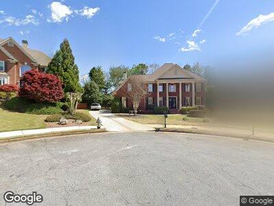
630 Tatum Ct Alpharetta, GA 30022
Estimated Value: $1,165,777 - $1,425,000
5
Beds
4
Baths
5,028
Sq Ft
$263/Sq Ft
Est. Value
About This Home
This home is located at 630 Tatum Ct, Alpharetta, GA 30022 and is currently estimated at $1,321,194, approximately $262 per square foot. 630 Tatum Ct is a home located in Fulton County with nearby schools including New Prospect Elementary School, Webb Bridge Middle School, and Alpharetta High School.
Ownership History
Date
Name
Owned For
Owner Type
Purchase Details
Closed on
Jul 6, 2005
Sold by
Odonnell John P and Odonnell Rhonda
Bought by
Camera Scott and Camera Elissa
Current Estimated Value
Home Financials for this Owner
Home Financials are based on the most recent Mortgage that was taken out on this home.
Original Mortgage
$359,650
Interest Rate
5.59%
Mortgage Type
New Conventional
Purchase Details
Closed on
Jun 30, 1999
Sold by
Newman Homes Inc
Bought by
O'Donnell John P and O'Donnell Rhonda K
Home Financials for this Owner
Home Financials are based on the most recent Mortgage that was taken out on this home.
Original Mortgage
$342,400
Interest Rate
7.23%
Mortgage Type
New Conventional
Create a Home Valuation Report for This Property
The Home Valuation Report is an in-depth analysis detailing your home's value as well as a comparison with similar homes in the area
Home Values in the Area
Average Home Value in this Area
Purchase History
| Date | Buyer | Sale Price | Title Company |
|---|---|---|---|
| Camera Scott | $610,000 | -- | |
| O'Donnell John P | $430,000 | -- |
Source: Public Records
Mortgage History
| Date | Status | Borrower | Loan Amount |
|---|---|---|---|
| Open | Camera Scott | $50,000 | |
| Open | -- | $390,000 | |
| Closed | Camera Scott T | $136,086 | |
| Closed | Scott Camera | $411,000 | |
| Closed | Camera Scott | $417,000 | |
| Closed | Camera Scott | $51,000 | |
| Closed | Camera Scott | $148,350 | |
| Closed | Camera Scott | $359,650 | |
| Previous Owner | Odonnell John P | $322,700 | |
| Previous Owner | Odonnell Rhonda K | $90,150 | |
| Previous Owner | O'Donnell John P | $342,400 |
Source: Public Records
Tax History Compared to Growth
Tax History
| Year | Tax Paid | Tax Assessment Tax Assessment Total Assessment is a certain percentage of the fair market value that is determined by local assessors to be the total taxable value of land and additions on the property. | Land | Improvement |
|---|---|---|---|---|
| 2023 | $11,462 | $406,080 | $68,720 | $337,360 |
| 2022 | $7,474 | $333,200 | $58,440 | $274,760 |
| 2021 | $8,675 | $285,280 | $48,880 | $236,400 |
| 2020 | $8,750 | $283,040 | $53,360 | $229,680 |
| 2019 | $1,344 | $267,320 | $50,280 | $217,040 |
| 2018 | $6,685 | $286,000 | $52,240 | $233,760 |
| 2017 | $7,886 | $258,960 | $47,680 | $211,280 |
| 2016 | $7,207 | $258,960 | $47,680 | $211,280 |
| 2015 | $7,458 | $258,960 | $47,680 | $211,280 |
| 2014 | $6,614 | $228,520 | $41,160 | $187,360 |
Source: Public Records
Map
Nearby Homes
- 605 Tatum Ct
- 225 Cotton Field Ct
- 230 Society St
- 2732 Wander Ln
- 3277 Bluejay Ln Unit 41
- 11212 Snowy Owl Ln Unit 46
- 1430 Hampton Hill Dr
- 315 Stanyan Place
- 10625 Haynes Forest Dr
- 3295 Waters Mill Dr
- 10900 Wittenridge Dr Unit L6
- 10900 Wittenridge Dr Unit I4
- 10900 Wittenridge Dr Unit D5
- 870 Thornberry Dr Unit 2
- 790 Thornberry Dr
- 210 Wentworth Terrace
- 370 Fairleaf Ct Unit 1
- 2715 Woods Ridge Dr
- 630 Tatum Ct
- 1115 Seale Dr
- 625 Tatum Ct
- 620 Tatum Ct
- 1105 Seale Dr
- 1125 Seale Dr
- 615 Tatum Ct
- 1095 Seale Dr
- 1095 Seale Dr Unit 5
- 610 Tatum Ct
- 715 Cottonfield Trace
- 415 Seale Trail
- 1100 Seale Dr
- 1135 Seale Dr
- 425 Seale Trail
- 720 Cottonfield Trace
- 1120 Seale Dr
- 1085 Seale Dr
- 1090 Seale Dr
- 600 Tatum Ct