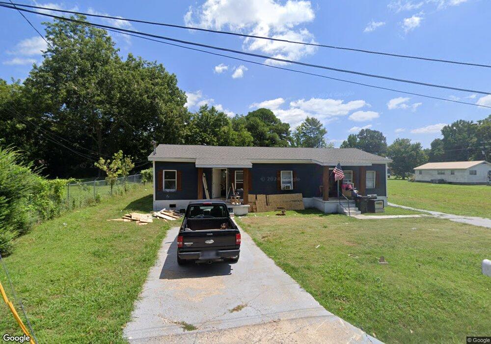
630 Thomas Ave Dyersburg, TN 38024
Estimated Value: $84,000 - $113,394
--
Bed
2
Baths
1,653
Sq Ft
$60/Sq Ft
Est. Value
About This Home
This home is located at 630 Thomas Ave, Dyersburg, TN 38024 and is currently estimated at $98,599, approximately $59 per square foot. 630 Thomas Ave is a home located in Dyer County with nearby schools including Dyersburg Primary School, Trimble Elementary School, and Dyersburg Intermediate School.
Ownership History
Date
Name
Owned For
Owner Type
Purchase Details
Closed on
Nov 9, 2023
Sold by
Puckett Elizabeth
Bought by
Jep Enterprises Llc
Current Estimated Value
Purchase Details
Closed on
Aug 18, 2023
Sold by
Crawley Charles
Bought by
Puckett Elizabeth
Purchase Details
Closed on
Mar 10, 2023
Sold by
Ail Scott Joe
Bought by
Crawley Charles
Purchase Details
Closed on
Dec 21, 2001
Sold by
Scott Mary Ruth
Bought by
Scott Joe Ail
Purchase Details
Closed on
Sep 1, 1981
Bought by
Scott Joe A and Scott Mary R
Create a Home Valuation Report for This Property
The Home Valuation Report is an in-depth analysis detailing your home's value as well as a comparison with similar homes in the area
Home Values in the Area
Average Home Value in this Area
Purchase History
| Date | Buyer | Sale Price | Title Company |
|---|---|---|---|
| Jep Enterprises Llc | -- | Dyer Land Title | |
| Puckett Elizabeth | -- | Dyer Land Title | |
| Crawley Charles | -- | Dyer Land Title | |
| Scott Joe Ail | -- | -- | |
| Scott Joe A | -- | -- |
Source: Public Records
Tax History Compared to Growth
Tax History
| Year | Tax Paid | Tax Assessment Tax Assessment Total Assessment is a certain percentage of the fair market value that is determined by local assessors to be the total taxable value of land and additions on the property. | Land | Improvement |
|---|---|---|---|---|
| 2024 | $263 | $10,680 | $1,720 | $8,960 |
| 2023 | $601 | $12,320 | $1,720 | $10,600 |
| 2022 | $590 | $12,320 | $1,720 | $10,600 |
| 2021 | $590 | $12,320 | $1,720 | $10,600 |
| 2020 | $584 | $12,320 | $1,720 | $10,600 |
| 2019 | $648 | $12,480 | $1,720 | $10,760 |
| 2018 | $626 | $12,480 | $1,720 | $10,760 |
| 2017 | $626 | $12,480 | $1,720 | $10,760 |
| 2016 | $626 | $12,480 | $1,720 | $10,760 |
| 2015 | $608 | $12,480 | $1,720 | $10,760 |
| 2014 | $591 | $12,480 | $1,720 | $10,760 |
Source: Public Records
Map
Nearby Homes
- 611 River St
- 529 Thomas Ave
- 807 Central St
- 809 Mclean Ave
- 214 Jordan Ave
- 615 E Court St
- 0 Compress St
- 1115 Grant St
- 1123 Grant St
- 206 Saint John Ave
- 122 Butterworth Ave
- 121 Reynolds Ave
- 206 Broadway Ave
- 850 Cherry St
- 419 N Sampson Ave
- 218 Reynolds Ave
- 403 Bell Ave
- 407 Bell Ave
- 512 Phillips St
- Lot 28 Scotsman
- 611 Roberts Ave
- 609 Roberts Ave
- 600 Fair St
- 629 Roberts Ave
- 538 Thomas Ave
- 631 Roberts Ave
- 603 Roberts Ave Unit 601
- 547 Thomas Ave
- 543 Thomas Ave
- 616 Roberts Ave
- 551 Roberts Ave
- 624 Roberts Ave
- 612 Roberts Ave
- 628 Roberts Ave
- 608 Roberts Ave
- 600 Roberts Ave
- 539 Thomas Ave
- 604 Roberts Ave
- 537 Thomas Ave
- 532 Thomas Ave