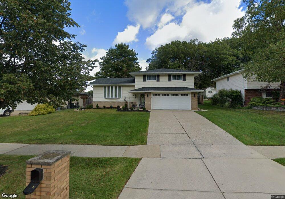
6300 Rousseau Dr Cleveland, OH 44129
Estimated Value: $284,687 - $315,000
4
Beds
2
Baths
2,004
Sq Ft
$150/Sq Ft
Est. Value
About This Home
This home is located at 6300 Rousseau Dr, Cleveland, OH 44129 and is currently estimated at $299,922, approximately $149 per square foot. 6300 Rousseau Dr is a home located in Cuyahoga County with nearby schools including Dentzler Elementary School, Normandy High School, and Hillside Middle School.
Ownership History
Date
Name
Owned For
Owner Type
Purchase Details
Closed on
Nov 26, 2004
Sold by
Boldt Lynda M
Bought by
Boldt Lynda M and Lynda M Boldt Trust
Current Estimated Value
Purchase Details
Closed on
Apr 7, 1989
Sold by
Hodgins Gregory A
Bought by
Sinclair Richard G
Purchase Details
Closed on
Dec 30, 1982
Bought by
Hodgins Gregory A
Purchase Details
Closed on
Nov 18, 1981
Sold by
Jones Paul R and Jones Patricia J
Bought by
H James Sheetz Trs
Purchase Details
Closed on
Jul 10, 1975
Sold by
Stayschik Carl and P J
Bought by
Jones Paul R and Jones Patricia J
Purchase Details
Closed on
Jan 1, 1975
Bought by
Stayschik Carl and P J
Create a Home Valuation Report for This Property
The Home Valuation Report is an in-depth analysis detailing your home's value as well as a comparison with similar homes in the area
Home Values in the Area
Average Home Value in this Area
Purchase History
| Date | Buyer | Sale Price | Title Company |
|---|---|---|---|
| Boldt Lynda M | -- | Attorney | |
| Sinclair Richard G | $105,000 | -- | |
| Hodgins Gregory A | $76,000 | -- | |
| H James Sheetz Trs | $81,800 | -- | |
| Jones Paul R | $59,000 | -- | |
| Stayschik Carl | -- | -- |
Source: Public Records
Tax History Compared to Growth
Tax History
| Year | Tax Paid | Tax Assessment Tax Assessment Total Assessment is a certain percentage of the fair market value that is determined by local assessors to be the total taxable value of land and additions on the property. | Land | Improvement |
|---|---|---|---|---|
| 2024 | $5,006 | $82,320 | $16,485 | $65,835 |
| 2023 | $4,631 | $65,950 | $14,040 | $51,910 |
| 2022 | $4,591 | $65,940 | $14,035 | $51,905 |
| 2021 | $4,727 | $65,940 | $14,040 | $51,910 |
| 2020 | $4,480 | $55,410 | $11,800 | $43,610 |
| 2019 | $4,314 | $158,300 | $33,700 | $124,600 |
| 2018 | $4,161 | $55,410 | $11,800 | $43,610 |
| 2017 | $4,157 | $49,500 | $10,260 | $39,240 |
| 2016 | $4,131 | $49,500 | $10,260 | $39,240 |
| 2015 | $4,084 | $49,500 | $10,260 | $39,240 |
| 2014 | $4,084 | $51,030 | $10,570 | $40,460 |
Source: Public Records
Map
Nearby Homes
- 6417 Thoreau Dr
- 7580 S Pointe Ln
- 7596 S Pointe Ln
- 7351 S Pointe Ln
- Rosecliff Plan at South Pointe - Townhomes
- Caroline Plan at South Pointe - Townhomes
- 5810 Ely Vista Dr
- 5602 Ely Vista Dr
- 4803 Sassafras Dr
- 6001 Williston Dr
- 6862 Talbot Dr
- 6882 Day Dr
- 7531 Vista Dr
- 8305 Banner Ln
- 8406 Fenway Dr
- 8375 Royal Ridge Dr
- 7272 Normandy Dr
- 8007 Sierra Oval
- 6813 Rolling Meadow Dr
- 4110 Pine Forest Dr
- 6310 Rousseau Dr
- 6214 Rousseau Dr
- 7241 Antoinette Dr
- 6206 Rousseau Dr
- 7237 Antoinette Dr
- 6217 Rousseau Dr
- 6400 Rousseau Dr
- 6303 Rousseau Dr
- 6209 Rousseau Dr
- 6311 Rousseau Dr
- 6200 Rousseau Dr
- 7233 Antoinette Dr
- 6201 Rousseau Dr
- 6317 Rousseau Dr
- 6414 Rousseau Dr
- 7240 Antoinette Dr
- 6116 Rousseau Dr
- 7236 Antoinette Dr
- 6403 Rousseau Dr
- 7229 Antoinette Dr