Estimated Value: $154,394 - $230,000
--
Bed
--
Bath
--
Sq Ft
0.46
Acres
About This Home
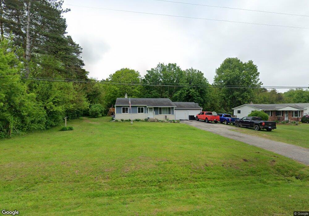
This home is located at 6305 W Frances Rd, Clio, MI 48420 and is currently estimated at $186,349. 6305 W Frances Rd is a home located in Genesee County with nearby schools including George R. Carter Middle School and Clio Area High School.
Ownership History
Date
Name
Owned For
Owner Type
Purchase Details
Closed on
Mar 25, 2003
Sold by
Allman Paul E and Allman Michelle
Bought by
Allman Paul E and Allman Michelle
Current Estimated Value
Home Financials for this Owner
Home Financials are based on the most recent Mortgage that was taken out on this home.
Original Mortgage
$95,486
Outstanding Balance
$41,229
Interest Rate
5.94%
Mortgage Type
FHA
Estimated Equity
$145,120
Purchase Details
Closed on
May 16, 2001
Sold by
Bailey Gordon E and Bailey Emerson
Bought by
Allman Paul E and Poulson Michelle
Purchase Details
Closed on
Apr 5, 1996
Sold by
Bailey Emerson
Bought by
Bailey Emerson and Bailey Gordon E
Create a Home Valuation Report for This Property
The Home Valuation Report is an in-depth analysis detailing your home's value as well as a comparison with similar homes in the area
Home Values in the Area
Average Home Value in this Area
Purchase History
| Date | Buyer | Sale Price | Title Company |
|---|---|---|---|
| Allman Paul E | -- | Greco Title | |
| Allman Paul E | $94,900 | Cislo Title Company | |
| Bailey Emerson | -- | -- |
Source: Public Records
Mortgage History
| Date | Status | Borrower | Loan Amount |
|---|---|---|---|
| Open | Allman Paul E | $95,486 |
Source: Public Records
Tax History Compared to Growth
Tax History
| Year | Tax Paid | Tax Assessment Tax Assessment Total Assessment is a certain percentage of the fair market value that is determined by local assessors to be the total taxable value of land and additions on the property. | Land | Improvement |
|---|---|---|---|---|
| 2025 | $1,835 | $71,400 | $0 | $0 |
| 2024 | $746 | $63,400 | $0 | $0 |
| 2023 | $712 | $57,400 | $0 | $0 |
| 2022 | $1,661 | $52,000 | $0 | $0 |
| 2021 | $1,620 | $47,800 | $0 | $0 |
| 2020 | $652 | $45,600 | $0 | $0 |
| 2019 | $567 | $41,500 | $0 | $0 |
| 2018 | $1,431 | $39,400 | $0 | $0 |
| 2017 | $1,375 | $37,100 | $0 | $0 |
| 2016 | $1,364 | $38,400 | $0 | $0 |
| 2015 | $1,230 | $36,400 | $0 | $0 |
| 2014 | $516 | $33,700 | $0 | $0 |
| 2012 | -- | $32,000 | $32,000 | $0 |
Source: Public Records
Map
Nearby Homes
- 9050 N Webster Rd
- integrity 1800 Plan at Thomas Estates - Integrity Collection
- Integrity 1830 Plan at Thomas Estates - Integrity Collection
- Elements 2700 Plan at Thomas Estates - Elements Collection
- Elements 2390 Plan at Thomas Estates - Elements Collection
- Elements 1800 Plan at Thomas Estates - Elements Collection
- Integrity 2000 Plan at Thomas Estates - Integrity Collection
- Elements 2200 Plan at Thomas Estates - Elements Collection
- Integrity 1880 Plan at Thomas Estates - Integrity Collection
- Integrity 2085 Plan at Thomas Estates - Integrity Collection
- Integrity 2190 Plan at Thomas Estates - Integrity Collection
- Integrity 1910 Plan at Thomas Estates - Integrity Collection
- Elements 1680 Plan at Thomas Estates - Elements Collection
- Integrity 1750 Plan at Thomas Estates - Integrity Collection
- Integrity 1605 Plan at Thomas Estates - Integrity Collection
- Elements 1870 Plan at Thomas Estates - Elements Collection
- Integrity 2061 V8.1 Plan at Thomas Estates - Integrity Collection
- Elements 2090 Plan at Thomas Estates - Elements Collection
- Integrity 2060 Plan at Thomas Estates - Integrity Collection
- Integrity 2080 Plan at Thomas Estates - Integrity Collection
- 6270 W Frances Rd
- 6290 W Frances Rd
- 6315 W Frances Rd
- 6260 W Frances Rd
- 6325 W Frances Rd
- 6300 W Frances Rd
- 9026 Forrest Pine Dr
- 6335 W Frances Rd
- 9027 Forrest Pine Dr
- 6343 W Frances Rd
- 6310 W Frances Rd
- 9038 Forrest Pine Dr
- 6349 W Frances Rd
- 9043 Forrest Pine Dr
- 6320 W Frances Rd
- 9048 Forrest Pine Dr
- 6357 W Frances Rd
- 6330 W Frances Rd
- 9062 Forrest Pine Dr
- 9063 Forrest Pine Dr