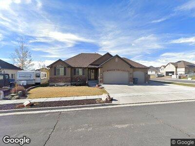
631 Michael Ave Evanston, WY 82930
Estimated Value: $452,007 - $525,000
3
Beds
2
Baths
1,315
Sq Ft
$371/Sq Ft
Est. Value
About This Home
This home is located at 631 Michael Ave, Evanston, WY 82930 and is currently estimated at $488,252, approximately $371 per square foot. 631 Michael Ave is a home located in Uinta County with nearby schools including Evanston High School and Evanston Child Development Center.
Ownership History
Date
Name
Owned For
Owner Type
Purchase Details
Closed on
Mar 28, 2023
Sold by
Janicek Barbara Marie
Bought by
Barbara M Janicek Trust
Current Estimated Value
Purchase Details
Closed on
May 15, 2008
Sold by
Nilson & Co Inc
Bought by
Gracia Robert Michael and Janicek Barbara Marie
Home Financials for this Owner
Home Financials are based on the most recent Mortgage that was taken out on this home.
Original Mortgage
$247,468
Interest Rate
5.89%
Mortgage Type
New Conventional
Create a Home Valuation Report for This Property
The Home Valuation Report is an in-depth analysis detailing your home's value as well as a comparison with similar homes in the area
Home Values in the Area
Average Home Value in this Area
Purchase History
| Date | Buyer | Sale Price | Title Company |
|---|---|---|---|
| Barbara M Janicek Trust | -- | None Listed On Document | |
| Gracia Robert Michael | -- | None Available |
Source: Public Records
Mortgage History
| Date | Status | Borrower | Loan Amount |
|---|---|---|---|
| Previous Owner | Janicek Barbara M | $205,400 | |
| Previous Owner | Janicek Barabara Marie | $252,000 | |
| Previous Owner | Gracia Robert Michael | $247,468 |
Source: Public Records
Tax History Compared to Growth
Tax History
| Year | Tax Paid | Tax Assessment Tax Assessment Total Assessment is a certain percentage of the fair market value that is determined by local assessors to be the total taxable value of land and additions on the property. | Land | Improvement |
|---|---|---|---|---|
| 2024 | $2,494 | $39,690 | $7,601 | $32,089 |
| 2023 | $2,398 | $38,456 | $7,601 | $30,855 |
| 2022 | $2,313 | $36,983 | $6,359 | $30,624 |
| 2021 | $1,820 | $29,697 | $6,236 | $23,461 |
| 2020 | $1,807 | $29,516 | $6,236 | $23,280 |
| 2019 | $1,795 | $29,397 | $6,236 | $23,161 |
| 2018 | $540 | $27,310 | $4,984 | $22,326 |
| 2017 | $1,616 | $26,782 | $4,537 | $22,245 |
| 2016 | $1,676 | $27,643 | $4,537 | $23,106 |
| 2015 | -- | $26,798 | $4,537 | $22,261 |
| 2014 | -- | $26,523 | $0 | $0 |
Source: Public Records
Map
Nearby Homes
- 405 Burns Ave Unit 3,4,5
- 405, 411, & 419 Burns Ave
- 325 Hathaway Ave
- 123 Red Hawk Ave
- 2884 lot #1207 Yellow Creek Rd
- 336 Emerson Ave
- 307 Hansen Ave
- 301 Emerson Ave
- 3925 Yellow Creek Rd
- 3893 Yellow Creek Rd
- 3861 Yellow Creek Rd
- 3827 Yellow Creek Rd
- 223 Barber Ave
- 221 Barber Ave
- 449 Billies Cir
- 225 Tomahawk Dr
- 319 Wright Way
- 325 Davis Dr
- 324 Ottley Ln
- 0 Prospector Dr
- 631 Michael Ave
- 625 Michael Ave
- 632 Gage Ave
- 628 Gage Ave
- 628 Gage Ave Unit Yellow Creek
- 628 Gage Ave Unit Burns
- 348 Burns Ave
- 348 Burns Ave Unit Gage Ave
- 341 Burns Ave
- 621 Michael Ave
- 352 Burns Ave
- 624 Michael Ave
- 344 Burns Ave
- 344 Burns Ave Unit Michael Avenue
- 624 Gage Ave
- 356 Burns Ave
- 620 Michael Ave
- 340 Burns Ave
- 337 Burns Ave
- 629 Gage Ave