Estimated Value: $344,000 - $357,000
3
Beds
2
Baths
1,603
Sq Ft
$219/Sq Ft
Est. Value
About This Home
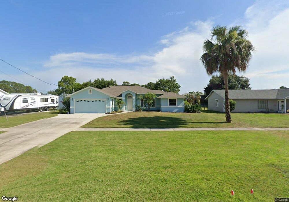
This home is located at 6310 Angus St, Cocoa, FL 32927 and is currently estimated at $351,589, approximately $219 per square foot. 6310 Angus St is a home located in Brevard County with nearby schools including Enterprise Elementary School and Space Coast Junior/Senior High School.
Ownership History
Date
Name
Owned For
Owner Type
Purchase Details
Closed on
Feb 26, 2001
Sold by
Mcclure William Jeffrey and Mcclure Christen L
Bought by
Marovich Cullen Jay J and Marovich Cullen Lisa M
Current Estimated Value
Purchase Details
Closed on
Oct 23, 1996
Sold by
Bagdonas Antanas H and Noy Dawn L
Bought by
Mcclure William Jeffrey and Mcclure Christen L
Home Financials for this Owner
Home Financials are based on the most recent Mortgage that was taken out on this home.
Original Mortgage
$13,089
Interest Rate
8.15%
Create a Home Valuation Report for This Property
The Home Valuation Report is an in-depth analysis detailing your home's value as well as a comparison with similar homes in the area
Home Values in the Area
Average Home Value in this Area
Purchase History
| Date | Buyer | Sale Price | Title Company |
|---|---|---|---|
| Marovich Cullen Jay J | $10,000 | -- | |
| Mcclure William Jeffrey | $8,200 | -- |
Source: Public Records
Mortgage History
| Date | Status | Borrower | Loan Amount |
|---|---|---|---|
| Previous Owner | Mcclure William Jeffrey | $13,089 |
Source: Public Records
Tax History Compared to Growth
Tax History
| Year | Tax Paid | Tax Assessment Tax Assessment Total Assessment is a certain percentage of the fair market value that is determined by local assessors to be the total taxable value of land and additions on the property. | Land | Improvement |
|---|---|---|---|---|
| 2025 | $1,604 | $118,570 | -- | -- |
| 2024 | $1,566 | $115,230 | -- | -- |
| 2023 | $1,566 | $111,880 | $0 | $0 |
| 2022 | $1,461 | $108,630 | $0 | $0 |
| 2021 | $1,465 | $105,470 | $0 | $0 |
| 2020 | $1,404 | $104,020 | $0 | $0 |
| 2019 | $1,341 | $101,690 | $0 | $0 |
| 2018 | $1,335 | $99,800 | $0 | $0 |
| 2017 | $1,331 | $97,750 | $0 | $0 |
| 2016 | $1,335 | $95,740 | $36,000 | $59,740 |
| 2015 | $1,354 | $95,080 | $30,000 | $65,080 |
| 2014 | $1,356 | $94,330 | $22,000 | $72,330 |
Source: Public Records
Map
Nearby Homes
- 6115 Allmont St
- 6295 Banyan St
- 6105 Banyan St
- 6545 Addie Ave
- 23-35-21-JX-B-2 Aruin St
- 6481 Muller Ave
- 6665 Addie Ave
- 6530 Bethel St
- 6365 Homestead Ave
- 6198 Dees Rd
- 6470 Aberdeen Ave
- 5915 Akers St
- 00000 Golfview Ave
- 6118 Dees Rd
- 6010 Fay Blvd
- 6070 Baltimore Ave
- 5715 Fairbridge St
- 0 Golfview Ave
- 6309 Alleghany Ave
- 4650 N Highway 1 Hwy