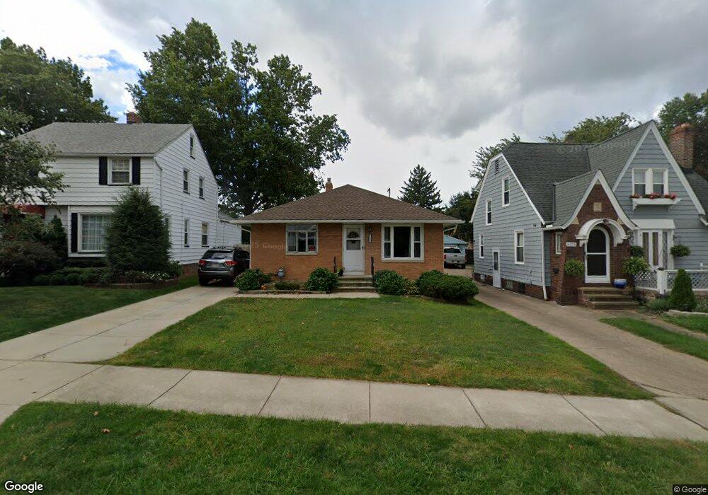
6311 Thornton Dr Cleveland, OH 44129
Estimated Value: $165,000 - $212,000
3
Beds
1
Bath
1,176
Sq Ft
$166/Sq Ft
Est. Value
About This Home
This home is located at 6311 Thornton Dr, Cleveland, OH 44129 and is currently estimated at $194,966, approximately $165 per square foot. 6311 Thornton Dr is a home located in Cuyahoga County with nearby schools including Renwood Elementary School, Thoreau Park Elementary School, and Shiloh Middle School.
Ownership History
Date
Name
Owned For
Owner Type
Purchase Details
Closed on
Oct 21, 1983
Sold by
Vaitekunas Telesforas
Bought by
Vaitekunas Elizabeth
Current Estimated Value
Purchase Details
Closed on
Feb 21, 1980
Sold by
Vaitekunas Telesforas and Vaitekunas Eliz
Bought by
Vaitekunas Telesforas
Purchase Details
Closed on
Jan 1, 1975
Bought by
Vaitekunas Telesforas and Vaitekunas Eliz
Create a Home Valuation Report for This Property
The Home Valuation Report is an in-depth analysis detailing your home's value as well as a comparison with similar homes in the area
Home Values in the Area
Average Home Value in this Area
Purchase History
| Date | Buyer | Sale Price | Title Company |
|---|---|---|---|
| Vaitekunas Elizabeth | -- | -- | |
| Vaitekunas Telesforas | -- | -- | |
| Vaitekunas Telesforas | -- | -- |
Source: Public Records
Tax History Compared to Growth
Tax History
| Year | Tax Paid | Tax Assessment Tax Assessment Total Assessment is a certain percentage of the fair market value that is determined by local assessors to be the total taxable value of land and additions on the property. | Land | Improvement |
|---|---|---|---|---|
| 2024 | $3,164 | $61,145 | $10,780 | $50,365 |
| 2023 | $2,688 | $46,380 | $9,560 | $36,820 |
| 2022 | $2,688 | $46,375 | $9,555 | $36,820 |
| 2021 | $2,763 | $46,380 | $9,560 | $36,820 |
| 2020 | $2,274 | $35,670 | $7,350 | $28,320 |
| 2019 | $2,160 | $101,900 | $21,000 | $80,900 |
| 2018 | $2,045 | $35,670 | $7,350 | $28,320 |
| 2017 | $2,063 | $32,520 | $5,670 | $26,850 |
| 2016 | $2,050 | $32,520 | $5,670 | $26,850 |
| 2015 | $1,959 | $32,520 | $5,670 | $26,850 |
| 2014 | $1,959 | $33,190 | $5,780 | $27,410 |
Source: Public Records
Map
Nearby Homes
- 6610 Renwood Dr
- 6708 Thornton Dr
- 6096 Wareham Dr
- 6111 Manchester Rd
- 7014 Thornton Dr
- 6406 Sunderland Dr
- 6818 Hampstead Ave
- 5603 Allanwood Dr
- 6168 Manchester Rd
- 6704 Charles Ave
- 7115 Hampstead Ave
- 6136 Ridge Rd
- 5815 Wilber Ave
- 6227 Ridge Rd
- 5415 Pelham Dr
- 6234 N Canterbury Rd
- 6903 Alber Ave
- 6510 Belmere Dr
- 6706 Alber Ave
- 6189 W 54th St
- 6315 Thornton Dr
- 6307 Thornton Dr
- 6303 Thornton Dr
- 6406 Brownfield Dr
- 6410 Brownfield Dr
- 6402 Brownfield Dr
- 6414 Brownfield Dr
- 6312 Brownfield Dr
- 6211 Thornton Dr
- 6306 Brownfield Dr
- 6310 Thornton Dr
- 6415 Thornton Dr
- 6318 Thornton Dr
- 6302 Brownfield Dr
- 6207 Thornton Dr
- 6506 Brownfield Dr
- 6208 Thornton Dr
- 6214 Brownfield Dr
- 6419 Thornton Dr
- 6510 Brownfield Dr