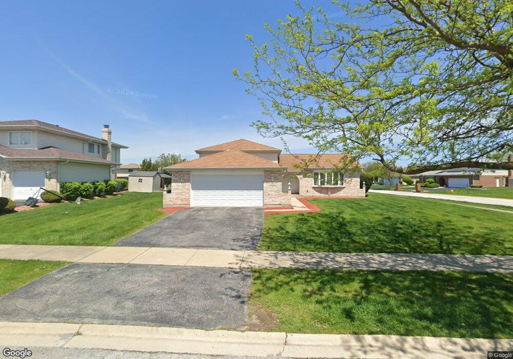
6318 Michael Ln Matteson, IL 60443
West Matteson NeighborhoodEstimated Value: $259,714 - $363,000
3
Beds
3
Baths
1,454
Sq Ft
$211/Sq Ft
Est. Value
About This Home
This home is located at 6318 Michael Ln, Matteson, IL 60443 and is currently estimated at $306,929, approximately $211 per square foot. 6318 Michael Ln is a home located in Cook County with nearby schools including Colin Powell Middle School and Dr. Wolfe's Montessori School.
Ownership History
Date
Name
Owned For
Owner Type
Purchase Details
Closed on
Dec 8, 2015
Sold by
Fannie Mae
Bought by
Wilburn Adrienne D and Taylor Barbara A
Current Estimated Value
Home Financials for this Owner
Home Financials are based on the most recent Mortgage that was taken out on this home.
Original Mortgage
$162,011
Outstanding Balance
$131,234
Interest Rate
4.62%
Mortgage Type
FHA
Estimated Equity
$175,695
Purchase Details
Closed on
Oct 27, 2014
Sold by
Favors John
Bought by
Federal National Mortgage Association
Purchase Details
Closed on
Jan 5, 2000
Sold by
South Holland Trust & Svgs Bank
Bought by
Favors John M and Tates Latonda M
Home Financials for this Owner
Home Financials are based on the most recent Mortgage that was taken out on this home.
Original Mortgage
$151,650
Interest Rate
7.98%
Create a Home Valuation Report for This Property
The Home Valuation Report is an in-depth analysis detailing your home's value as well as a comparison with similar homes in the area
Home Values in the Area
Average Home Value in this Area
Purchase History
| Date | Buyer | Sale Price | Title Company |
|---|---|---|---|
| Wilburn Adrienne D | $165,000 | Central Illinois Title Co | |
| Federal National Mortgage Association | -- | None Available | |
| Favors John M | $169,000 | First American Title |
Source: Public Records
Mortgage History
| Date | Status | Borrower | Loan Amount |
|---|---|---|---|
| Open | Wilburn Adrienne D | $162,011 | |
| Previous Owner | Favors John M | $151,650 |
Source: Public Records
Tax History Compared to Growth
Tax History
| Year | Tax Paid | Tax Assessment Tax Assessment Total Assessment is a certain percentage of the fair market value that is determined by local assessors to be the total taxable value of land and additions on the property. | Land | Improvement |
|---|---|---|---|---|
| 2024 | $6,259 | $17,422 | $5,514 | $11,908 |
| 2023 | $5,400 | $17,422 | $5,514 | $11,908 |
| 2022 | $5,400 | $12,480 | $4,762 | $7,718 |
| 2021 | $5,484 | $12,479 | $4,761 | $7,718 |
| 2020 | $5,383 | $12,479 | $4,761 | $7,718 |
| 2019 | $5,025 | $11,597 | $4,260 | $7,337 |
| 2018 | $4,949 | $11,597 | $4,260 | $7,337 |
| 2017 | $4,834 | $11,597 | $4,260 | $7,337 |
| 2016 | $5,113 | $11,629 | $3,759 | $7,870 |
| 2015 | $4,976 | $11,629 | $3,759 | $7,870 |
| 2014 | $4,860 | $11,629 | $3,759 | $7,870 |
| 2013 | $5,059 | $12,838 | $3,759 | $9,079 |
Source: Public Records
Map
Nearby Homes
- 50 Willow Rd
- 433 Wheatfield Rd
- 6226 Beechwood Rd
- 10 Wedgewood Rd
- 42 Pheasant Rd
- 6230 Streamwood Ln
- 123 Oriole Rd
- 6306 Beaver Dam Rd
- 217 Oriole Rd
- 5943 Woodgate Dr
- 25 Pheasant Rd
- 5911 Timberlane Rd
- 13 Oakview Rd
- 6260 Sunflower Dr
- 12 Iliad Dr
- 6037 Spring Ln
- 5838 Woodgate Dr
- 6021 Spring Ln
- 111 Deerpath Rd
- 6125 Sunflower Dr
- 6318 Michael Ln
- 6326 Michael Ln
- 6317 Michael Ln
- 6325 Michael Ln
- 6334 Michael Ln
- 6334 Michael Ln
- 6300 Michael Ln
- 6300 Michael Ln
- 6309 Michael Ln
- 122 Old Mill Rd
- 6333 Michael Ln
- 6301 Michael Ln
- 133 Old Mill Rd
- 6337 Applehill Rd
- 6258 Michael Ln
- 6258 Michael Ln
- 6316 Virginia Ln
- 6261 Michael Ln
- 6324 Virginia Ln
- 123 Old Mill Rd