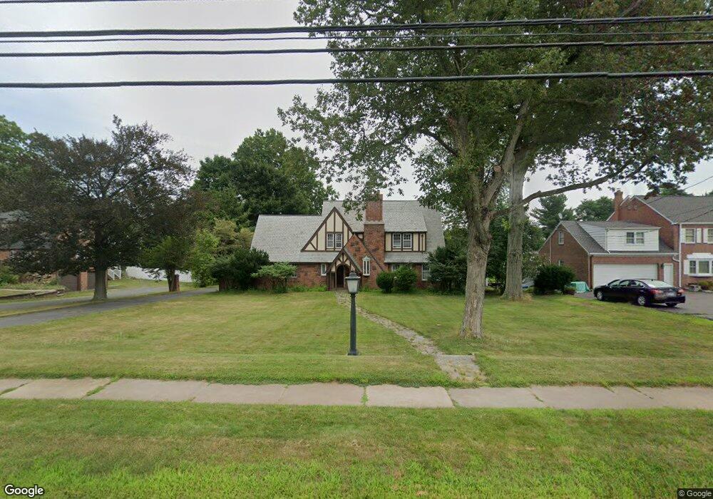
632 Ridge Rd Wethersfield, CT 06109
Estimated Value: $555,000 - $650,000
4
Beds
3
Baths
2,086
Sq Ft
$286/Sq Ft
Est. Value
About This Home
This home is located at 632 Ridge Rd, Wethersfield, CT 06109 and is currently estimated at $596,711, approximately $286 per square foot. 632 Ridge Rd is a home located in Hartford County with nearby schools including Emerson-Williams School, Silas Deane Middle School, and Wethersfield High School.
Ownership History
Date
Name
Owned For
Owner Type
Purchase Details
Closed on
Aug 15, 2000
Sold by
Anderson Victor A and Boutte Martine M
Bought by
Chapp Thomas Robert and Sognnaes Johanne A
Current Estimated Value
Purchase Details
Closed on
May 3, 1993
Sold by
Tine Michael P and Tine Elizabeth
Bought by
Anderson Victor A and Boutte Martine M
Purchase Details
Closed on
Aug 12, 1988
Sold by
Miller Andres M
Bought by
Tine Michael P
Create a Home Valuation Report for This Property
The Home Valuation Report is an in-depth analysis detailing your home's value as well as a comparison with similar homes in the area
Home Values in the Area
Average Home Value in this Area
Purchase History
| Date | Buyer | Sale Price | Title Company |
|---|---|---|---|
| Chapp Thomas Robert | $288,000 | -- | |
| Anderson Victor A | $260,000 | -- | |
| Tine Michael P | $355,000 | -- |
Source: Public Records
Mortgage History
| Date | Status | Borrower | Loan Amount |
|---|---|---|---|
| Open | Tine Michael P | $162,000 | |
| Closed | Tine Michael P | $155,000 | |
| Closed | Tine Michael P | $30,000 |
Source: Public Records
Tax History
| Year | Tax Paid | Tax Assessment Tax Assessment Total Assessment is a certain percentage of the fair market value that is determined by local assessors to be the total taxable value of land and additions on the property. | Land | Improvement |
|---|---|---|---|---|
| 2025 | $13,457 | $326,470 | $105,060 | $221,410 |
| 2024 | $9,075 | $209,980 | $75,700 | $134,280 |
| 2023 | $9,685 | $231,810 | $75,700 | $156,110 |
| 2022 | $9,523 | $231,810 | $75,700 | $156,110 |
| 2021 | $9,428 | $231,810 | $75,700 | $156,110 |
| 2020 | $9,307 | $228,730 | $75,700 | $153,030 |
| 2019 | $9,318 | $228,730 | $75,700 | $153,030 |
| 2018 | $9,261 | $227,100 | $79,100 | $148,000 |
| 2017 | $9,032 | $227,100 | $79,100 | $148,000 |
| 2016 | $8,752 | $227,100 | $79,100 | $148,000 |
| 2015 | $8,673 | $227,100 | $79,100 | $148,000 |
| 2014 | $8,344 | $227,100 | $79,100 | $148,000 |
Source: Public Records
Map
Nearby Homes
- 764 Ridge Rd
- 20 Forest Dr
- 273 Forest Dr
- 129 Goff Rd
- 173 Timber Trail
- 35 Kingston St
- 158 Dix Rd
- 455 Brimfield Rd
- 295 Ridge Rd Unit 8
- 137 Dale Rd
- 7 Barrington Dr Unit C
- 15 Potter Crossing
- 25 Tinsmith Crossing
- 62 Schoolhouse Crossing
- 250 Edward St
- 39 Schoolhouse Crossing
- 1 Bristol St
- 89 Merriman Rd
- 19 Albert Ave
- 38 Wheeler Rd
Your Personal Tour Guide
Ask me questions while you tour the home.