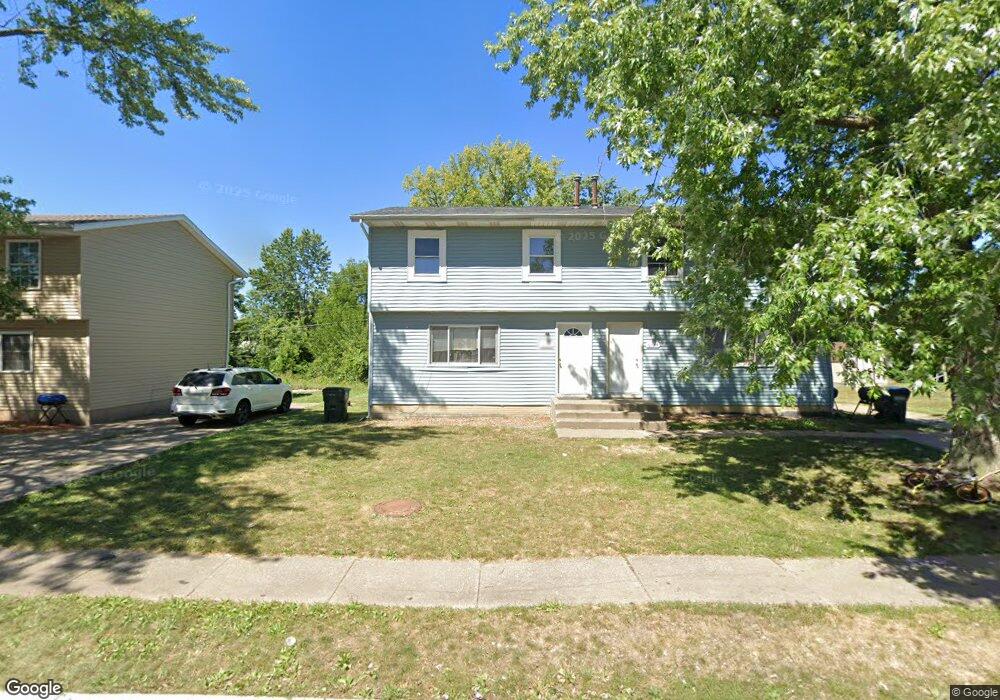
6322 Appomattox Rd Unit 2, 24 Davenport, IA 52806
North Side NeighborhoodEstimated Value: $155,000 - $175,523
6
Beds
2
Baths
560
Sq Ft
$294/Sq Ft
Est. Value
About This Home
This home is located at 6322 Appomattox Rd Unit 2, 24, Davenport, IA 52806 and is currently estimated at $164,631, approximately $293 per square foot. 6322 Appomattox Rd Unit 2, 24 is a home located in Scott County with nearby schools including Cumberland Hall School, Academy Of Continuing Education, and Wood Intermediate School.
Ownership History
Date
Name
Owned For
Owner Type
Purchase Details
Closed on
Nov 25, 2020
Sold by
Rivera Christia and Nache Joseph A
Bought by
Dehalva Properties Llc
Current Estimated Value
Home Financials for this Owner
Home Financials are based on the most recent Mortgage that was taken out on this home.
Original Mortgage
$116,000
Outstanding Balance
$2,069
Interest Rate
2.8%
Mortgage Type
New Conventional
Estimated Equity
$162,562
Purchase Details
Closed on
Feb 23, 2010
Sold by
Cotton Gregory A and Cotton Shauna N
Bought by
Ckc Llc
Create a Home Valuation Report for This Property
The Home Valuation Report is an in-depth analysis detailing your home's value as well as a comparison with similar homes in the area
Home Values in the Area
Average Home Value in this Area
Purchase History
| Date | Buyer | Sale Price | Title Company |
|---|---|---|---|
| Dehalva Properties Llc | $116,000 | None Listed On Document | |
| Ckc Llc | -- | None Available |
Source: Public Records
Mortgage History
| Date | Status | Borrower | Loan Amount |
|---|---|---|---|
| Open | Dehalva Properties Llc | $116,000 |
Source: Public Records
Tax History Compared to Growth
Tax History
| Year | Tax Paid | Tax Assessment Tax Assessment Total Assessment is a certain percentage of the fair market value that is determined by local assessors to be the total taxable value of land and additions on the property. | Land | Improvement |
|---|---|---|---|---|
| 2025 | $2,540 | $139,770 | $25,760 | $114,010 |
| 2024 | $3,539 | $142,150 | $25,760 | $116,390 |
| 2023 | $3,478 | $142,150 | $25,760 | $116,390 |
| 2022 | $3,947 | $114,700 | $16,100 | $98,600 |
| 2021 | $2,358 | $109,870 | $16,100 | $93,770 |
| 2020 | $2,995 | $101,170 | $16,100 | $85,070 |
| 2019 | $2,384 | $86,530 | $16,100 | $70,430 |
| 2018 | $2,811 | $86,530 | $16,100 | $70,430 |
| 2017 | $3,437 | $82,390 | $16,100 | $66,290 |
| 2016 | $2,854 | $82,390 | $0 | $0 |
| 2015 | $1,804 | $88,100 | $0 | $0 |
| 2014 | $1,956 | $88,100 | $0 | $0 |
| 2013 | $1,922 | $0 | $0 | $0 |
| 2012 | -- | $85,490 | $16,950 | $68,540 |
Source: Public Records
Map
Nearby Homes
- 6322 Appomattox Rd
- 6308 Appomattox Rd
- LOT 54 Franklin Ave
- Lot 56 Franklin Ave
- 671 W 64th St
- 665 W 64th St
- 655 W 64th St
- Lot 26 Benjamin Ct
- 6112 Western Ave
- 6015 Vine St
- 6205 N Ripley St
- 1301 W 62nd Ct
- 1005 W 58th St
- 1033 W 58th St
- 5804 Lillie Ave
- 6209 Fair Ave
- 6127 Fair Ave
- 5735 Taylor St
- 5721 Taylor St
- 1415 W 59th St
- 6322-6324 Appomattox Rd
- 6324 Appomattox Rd
- 6322 & 6324 Appomattox Rd
- 6314 Appomattox Rd
- 6400 Appomattox Rd
- 6406 Appomattox Rd
- 6404 Appomattox Rd
- 738 W 63rd St
- 6302 Appomattox Rd
- 6405 Appomattox Rd
- 6405 Appomattox Rd
- 679 W 64th St
- 6410 Appomattox Rd
- 728 W 63rd St
- 674 W 64th St
- Prcl X0233-16 Franklin Ave
- LOT 48 Franklin Ave
- LOT 53 Franklin Ave
- 0 Franklin Ave
- 0 Franklin Ave