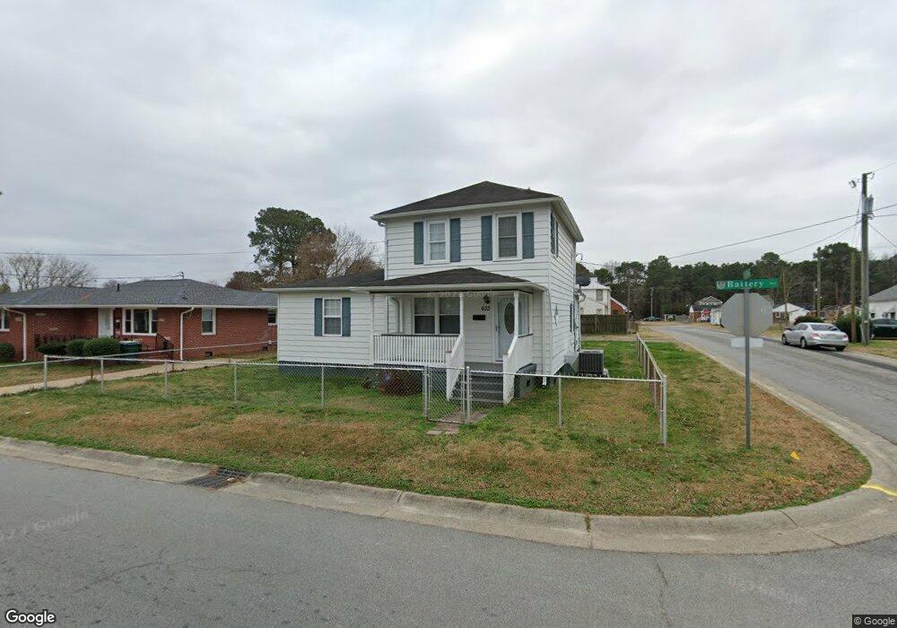
633 Battery Ave Suffolk, VA 23434
Holy Neck NeighborhoodEstimated Value: $182,000 - $265,000
3
Beds
2
Baths
1,728
Sq Ft
$127/Sq Ft
Est. Value
About This Home
This home is located at 633 Battery Ave, Suffolk, VA 23434 and is currently estimated at $219,563, approximately $127 per square foot. 633 Battery Ave is a home located in Suffolk City with nearby schools including Hillpoint Elementary School, Forest Glen Middle School, and Lakeland High School.
Ownership History
Date
Name
Owned For
Owner Type
Purchase Details
Closed on
Jun 11, 2020
Sold by
Joseph Sherwin Kevin
Bought by
Simpson Doretha H
Current Estimated Value
Home Financials for this Owner
Home Financials are based on the most recent Mortgage that was taken out on this home.
Original Mortgage
$117,826
Outstanding Balance
$103,749
Interest Rate
3.2%
Mortgage Type
FHA
Estimated Equity
$115,814
Create a Home Valuation Report for This Property
The Home Valuation Report is an in-depth analysis detailing your home's value as well as a comparison with similar homes in the area
Home Values in the Area
Average Home Value in this Area
Purchase History
| Date | Buyer | Sale Price | Title Company |
|---|---|---|---|
| Simpson Doretha H | $120,000 | Attorney |
Source: Public Records
Mortgage History
| Date | Status | Borrower | Loan Amount |
|---|---|---|---|
| Open | Simpson Doretha H | $117,826 |
Source: Public Records
Tax History
| Year | Tax Paid | Tax Assessment Tax Assessment Total Assessment is a certain percentage of the fair market value that is determined by local assessors to be the total taxable value of land and additions on the property. | Land | Improvement |
|---|---|---|---|---|
| 2025 | $450 | $154,500 | $49,100 | $105,400 |
| 2024 | $450 | $149,900 | $49,100 | $100,800 |
| 2023 | $393 | $142,900 | $46,800 | $96,100 |
| 2022 | $1,249 | $114,600 | $33,400 | $81,200 |
| 2021 | $1,198 | $107,900 | $26,700 | $81,200 |
| 2020 | $1,107 | $99,700 | $24,300 | $75,400 |
| 2019 | $1,107 | $99,700 | $24,300 | $75,400 |
| 2018 | $1,237 | $99,300 | $24,300 | $75,000 |
| 2017 | $1,063 | $99,300 | $24,300 | $75,000 |
| 2016 | $1,063 | $99,300 | $24,300 | $75,000 |
| 2015 | $670 | $102,900 | $24,300 | $78,600 |
| 2014 | $670 | $102,900 | $24,300 | $78,600 |
Source: Public Records
Map
Nearby Homes
- 711 Brook Ave
- 608 Battery Ave
- 721 Ashley Ave Unit A
- 532 Battery Ave
- 731 Brook Ave
- 729 Brook Ave
- 814 Battery Ave
- 812 Battery Ave
- 603 Mason Ave
- 435 Wellons St
- 441 Wellons St
- 439 Wellons St
- 437 Wellons St
- 433 Wellons St
- 314 Linden Ave
- 309 Linden Ave
- 201 Brook Ave
- 212 Saint James Ave
- 215 Wellons St
- 207 Causey Ave
- 627 Battery Ave
- 701 Battery Ave
- 630 Brook Ave
- 623 Battery Ave
- 705 Battery Ave
- 632 Battery Ave
- 628 Battery Ave
- 702 Brook Ave
- 700 Battery Ave
- 707 Battery Ave
- 626 Battery Ave Unit B
- 626 Battery Ave Unit B
- 626 Battery Ave
- 704 Brook Ave
- 622 Battery Ave
- LOT Brooks
- Lot 1 Brook Ave
- Lot 33 Brook Ave
- 702 Battery Ave
- 709 Battery Ave
Your Personal Tour Guide
Ask me questions while you tour the home.