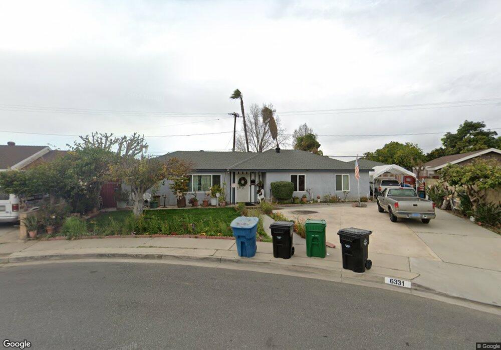
6331 Kiowa Rd Westminster, CA 92683
Estimated Value: $947,585 - $1,106,000
4
Beds
2
Baths
1,478
Sq Ft
$714/Sq Ft
Est. Value
About This Home
This home is located at 6331 Kiowa Rd, Westminster, CA 92683 and is currently estimated at $1,055,396, approximately $714 per square foot. 6331 Kiowa Rd is a home located in Orange County with nearby schools including Finley Elementary, Johnson Middle, and Westminster High School.
Ownership History
Date
Name
Owned For
Owner Type
Purchase Details
Closed on
Aug 24, 2023
Sold by
Rodriguez Ruben R
Bought by
Ruben R Rodriguez Separate Property Revocable and Rodriguez
Current Estimated Value
Purchase Details
Closed on
Jun 19, 2023
Sold by
Rodriguez Roy Roland
Bought by
Roy Roland Rodriguez Revocable Trust and Rodriguez
Purchase Details
Closed on
Apr 20, 2023
Sold by
Connie Rodriguez Revocable Trust
Bought by
Rodriguez Roy and Rodriguez Ruben
Purchase Details
Closed on
Sep 2, 2005
Sold by
Rodriguez Connie
Bought by
Rodriguez Connie and The Connie Rodriguez Revocable Trust
Create a Home Valuation Report for This Property
The Home Valuation Report is an in-depth analysis detailing your home's value as well as a comparison with similar homes in the area
Home Values in the Area
Average Home Value in this Area
Purchase History
| Date | Buyer | Sale Price | Title Company |
|---|---|---|---|
| Ruben R Rodriguez Separate Property Revocable | -- | None Listed On Document | |
| Roy Roland Rodriguez Revocable Trust | -- | None Listed On Document | |
| Rodriguez Roy | -- | None Listed On Document | |
| Rodriguez Connie | -- | -- |
Source: Public Records
Tax History
| Year | Tax Paid | Tax Assessment Tax Assessment Total Assessment is a certain percentage of the fair market value that is determined by local assessors to be the total taxable value of land and additions on the property. | Land | Improvement |
|---|---|---|---|---|
| 2025 | $4,567 | $351,536 | $297,262 | $54,274 |
| 2024 | $4,567 | $344,644 | $291,434 | $53,210 |
| 2023 | $1,330 | $66,831 | $24,286 | $42,545 |
| 2022 | $1,300 | $65,521 | $23,810 | $41,711 |
| 2021 | $1,256 | $64,237 | $23,343 | $40,894 |
| 2020 | $1,243 | $63,579 | $23,104 | $40,475 |
| 2019 | $1,234 | $62,333 | $22,651 | $39,682 |
| 2018 | $1,229 | $61,111 | $22,207 | $38,904 |
| 2017 | $1,198 | $59,913 | $21,771 | $38,142 |
| 2016 | $1,173 | $58,739 | $21,344 | $37,395 |
| 2015 | $1,156 | $57,857 | $21,023 | $36,834 |
| 2014 | $1,134 | $56,724 | $20,611 | $36,113 |
Source: Public Records
Map
Nearby Homes
- 6282 Cheyenne Dr
- 13036 Springarden Ln
- 13352 Springdale St
- 6632 Trask Ave
- 6071 Modoc Rd
- 6091 Navajo Rd
- 13161 Summit Cir
- 6751 Klondike Ave
- 6216 Hefley St Unit 3
- 6889 Danvers Dr
- 6949 Danvers Dr
- 6848 Citriadora Ct
- 6181 Lenore Ave
- 12552 Fieldstone Ln Unit 101
- 6971 Knollcrest Ln Unit 47
- 6952 Brightwood Ln Unit 3
- 5382 Laverne Cir
- 6052 Mahogany Ave
- 5302 Clark Cir
- 5566 Aldershot Walk
- 6321 Kiowa Rd
- 6341 Kiowa Rd
- 6332 Iroquois Rd
- 6312 Iroquois Rd
- 6342 Iroquois Rd
- 6302 Iroquois Rd
- 6315 Kiowa Rd
- 6351 Kiowa Rd
- 6332 Kiowa Rd
- 6352 Iroquois Rd
- 6311 Cayuga Dr
- 6292 Iroquois Rd
- 6352 Kiowa Rd
- 6311 Kiowa Rd
- 6361 Kiowa Rd
- 6362 Iroquois Rd
- 6282 Iroquois Rd
- 6321 Cayuga Dr
- 13162 Seneca Dr
- 6341 Iroquois Rd
Your Personal Tour Guide
Ask me questions while you tour the home.