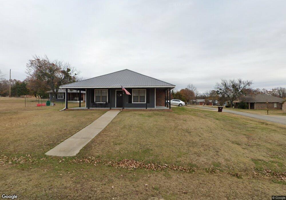
634 Mohawk Dr Eufaula, OK 74432
Estimated Value: $238,445 - $279,000
3
Beds
2
Baths
1,520
Sq Ft
$173/Sq Ft
Est. Value
About This Home
This home is located at 634 Mohawk Dr, Eufaula, OK 74432 and is currently estimated at $262,861, approximately $172 per square foot. 634 Mohawk Dr is a home located in McIntosh County with nearby schools including Eufaula Elementary School, Eufaula Middle School, and Eufaula High School.
Ownership History
Date
Name
Owned For
Owner Type
Purchase Details
Closed on
Mar 8, 2019
Sold by
Bokf Na
Bought by
Lockwood Vonda
Current Estimated Value
Purchase Details
Closed on
Aug 15, 2014
Sold by
Hazelwood Donald J
Bought by
Rice Steven N and Rice Seeson
Purchase Details
Closed on
Dec 13, 2013
Sold by
Lester Stan Paul and Lester Rondi
Bought by
Hazelwood Donald J
Purchase Details
Closed on
Jun 13, 2006
Sold by
Tomlinston David L and Tomlinston Nancy A
Bought by
Lester Stan Paul and Lester Rondi
Home Financials for this Owner
Home Financials are based on the most recent Mortgage that was taken out on this home.
Original Mortgage
$74,500
Interest Rate
6.56%
Mortgage Type
New Conventional
Purchase Details
Closed on
Apr 6, 2005
Sold by
Burrett Benny R and Burrett Ereda A
Bought by
Tomlinson David L and Tomlinson Nancy A
Create a Home Valuation Report for This Property
The Home Valuation Report is an in-depth analysis detailing your home's value as well as a comparison with similar homes in the area
Home Values in the Area
Average Home Value in this Area
Purchase History
| Date | Buyer | Sale Price | Title Company |
|---|---|---|---|
| Lockwood Vonda | $104,500 | Nations Title Of Okc | |
| Rice Steven N | $132,000 | -- | |
| Hazelwood Donald J | $96,000 | -- | |
| Lester Stan Paul | $99,500 | None Available | |
| Tomlinson David L | $5,000 | None Available |
Source: Public Records
Mortgage History
| Date | Status | Borrower | Loan Amount |
|---|---|---|---|
| Previous Owner | Lester Stan Paul | $74,500 |
Source: Public Records
Tax History
| Year | Tax Paid | Tax Assessment Tax Assessment Total Assessment is a certain percentage of the fair market value that is determined by local assessors to be the total taxable value of land and additions on the property. | Land | Improvement |
|---|---|---|---|---|
| 2025 | $1,411 | $17,123 | $705 | $16,418 |
| 2024 | $1,365 | $17,124 | $710 | $16,414 |
| 2023 | $1,365 | $16,140 | $660 | $15,480 |
| 2022 | $1,134 | $15,670 | $660 | $15,010 |
| 2021 | $1,277 | $15,214 | $660 | $14,554 |
| 2020 | $1,277 | $15,214 | $660 | $14,554 |
| 2019 | $1,376 | $16,251 | $660 | $15,591 |
| 2018 | $1,353 | $16,251 | $660 | $15,591 |
| 2017 | $1,261 | $16,134 | $655 | $15,479 |
| 2016 | $1,227 | $15,665 | $583 | $15,082 |
| 2015 | $1,173 | $15,209 | $440 | $14,769 |
| 2014 | $1,281 | $15,613 | $440 | $15,173 |
Source: Public Records
Map
Nearby Homes
- 4 E 1200
- 589 Mohawk
- 6 E 1200
- 8 E 1200
- 721 Mohawk Dr
- 0 Quapaw St Unit 2540983
- 229 Seminole Dr
- 230 Seminole Dr
- 0 Choctaw Dr Unit 2514518
- 0 Choctaw Dr Unit 2515676
- 0 Choctaw Dr Unit 2515656
- 0000 Choctaw Dr
- 120290 S 4182 Rd
- 989 Sequoyah Dr
- 411 Booker t Washington St
- 7018 Lakeshore Dr Unit 18
- 120347 S 4186 Rd
- 701 Lakeshore Dr
- 0 Comanche Dr Unit OKC1219168
- 107 N J St
- 634 Mohawk Dr
- 0 Cherokee Dr Unit 1543780
- 0 Cherokee Dr Unit 2000352
- 0 Cherokee Dr Unit 2023251
- 0 Cherokee Dr Unit 2210176
- 0 Cherokee Dr Unit 2210174
- 000 Cherokee Dr
- 705 Creek Dr
- 154 Sequoyah Dr
- 992 Sequoyah Dr
- 685 Cherokee Dr
- 635 Mohawk Dr
- 645 Mohawk Dr
- 0 Creek Dr
- 564 Mohawk Dr
- 664 Cherokee Dr
- 19245 County Road 1550
- 972 Creek Dr
- 578 Mohawk Dr
- 659 Mohawk Dr
Your Personal Tour Guide
Ask me questions while you tour the home.