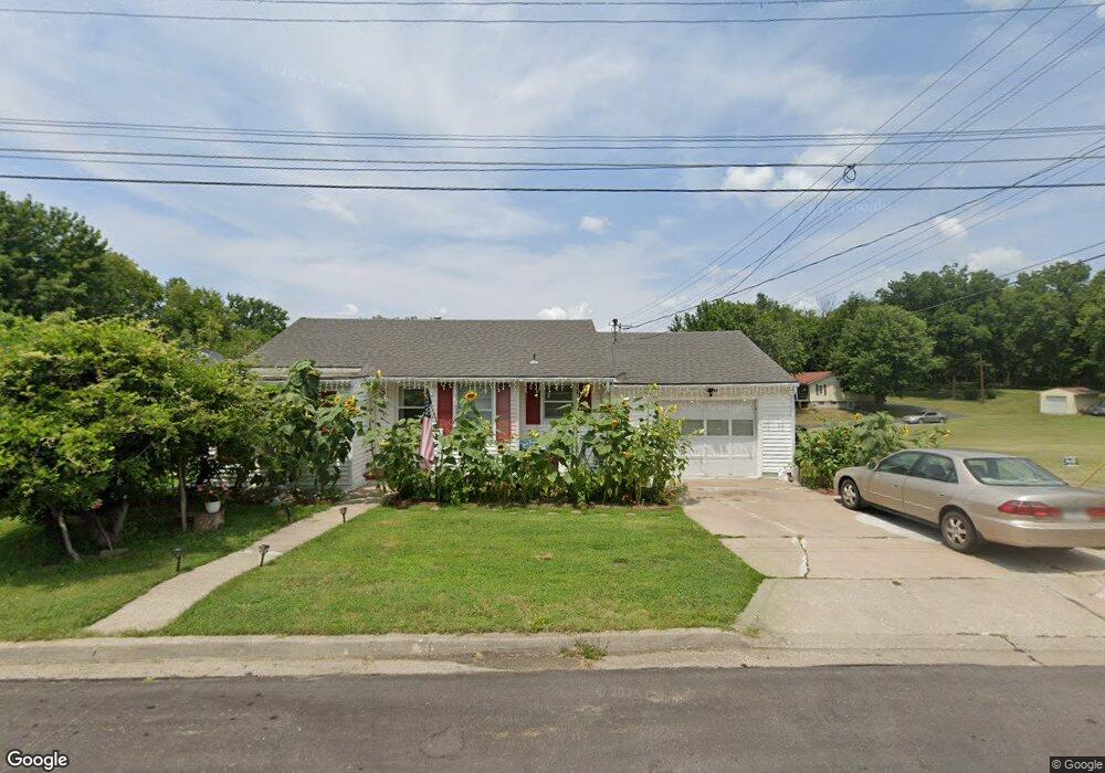
635 E Thomas St Marshall, MO 65340
Estimated Value: $117,000 - $125,000
2
Beds
1
Bath
800
Sq Ft
$151/Sq Ft
Est. Value
About This Home
This home is located at 635 E Thomas St, Marshall, MO 65340 and is currently estimated at $120,445, approximately $150 per square foot. 635 E Thomas St is a home located in Saline County with nearby schools including Marshall Senior High School, St. Peter Catholic School, and Calvary Baptist School.
Ownership History
Date
Name
Owned For
Owner Type
Purchase Details
Closed on
Jun 26, 2015
Sold by
Napier Tessie M
Bought by
Ramos Wendy Y and Ramos Julio A
Current Estimated Value
Home Financials for this Owner
Home Financials are based on the most recent Mortgage that was taken out on this home.
Original Mortgage
$49,400
Outstanding Balance
$38,371
Interest Rate
3.91%
Mortgage Type
New Conventional
Estimated Equity
$82,074
Create a Home Valuation Report for This Property
The Home Valuation Report is an in-depth analysis detailing your home's value as well as a comparison with similar homes in the area
Home Values in the Area
Average Home Value in this Area
Purchase History
| Date | Buyer | Sale Price | Title Company |
|---|---|---|---|
| Ramos Wendy Y | $61,750 | Saline County Abstract & Guara |
Source: Public Records
Mortgage History
| Date | Status | Borrower | Loan Amount |
|---|---|---|---|
| Open | Ramos Wendy Y | $49,400 |
Source: Public Records
Tax History
| Year | Tax Paid | Tax Assessment Tax Assessment Total Assessment is a certain percentage of the fair market value that is determined by local assessors to be the total taxable value of land and additions on the property. | Land | Improvement |
|---|---|---|---|---|
| 2025 | $841 | $15,770 | $2,760 | $13,010 |
| 2024 | $842 | $13,710 | $2,400 | $11,310 |
| 2023 | $842 | $13,710 | $2,400 | $11,310 |
| 2022 | $667 | $13,710 | $2,400 | $11,310 |
| 2021 | $666 | $13,710 | $2,400 | $11,310 |
| 2020 | $529 | $9,670 | $9,670 | $0 |
| 2019 | $521 | $9,670 | $9,670 | $0 |
| 2018 | $518 | $9,670 | $9,670 | $0 |
| 2017 | $521 | $9,670 | $0 | $0 |
| 2016 | -- | $9,670 | $0 | $0 |
| 2015 | -- | $9,670 | $0 | $0 |
| 2014 | -- | $9,670 | $0 | $0 |
Source: Public Records
Map
Nearby Homes
- 610 E Arrow St
- 506 E Jackson St
- 455 S Redman Ave
- 327 E Yerby St
- 602 E Gordon St
- 307 E Arrow St
- 316 E Summit St
- 531 E Eastwood St
- 503 E Eastwood St
- 1015 E Eastwood St
- 911 S Redwing Dr
- 1129 Fairlawn Ave
- 457 S Jefferson Ave
- 219 E Gordon St
- 404/408 S Redman Ave
- 518 N Brunswick Ave
- 1117S S Whippoorwill Dr
- 406 N Odell Ave
- 224 E Porter St
- 532 E Lacy St
- 631 E Thomas St
- 638 E Thomas St
- 630 E Thomas St
- 626 E Thomas St
- 547 S Lincoln Ave
- 604 E Thomas St
- 553 S Lincoln Ave
- 400 S Lincoln Ave
- 351 S Lincoln Ave
- 556 S Lincoln Ave
- 602 E Thomas St
- 558 S A & B S Lincoln St
- 560 S Lincoln Ave
- 755 E Thomas St
- 626 E Washington St
- 623 S Lincoln Ave
- 620 E Washington St
- 217 S Lincoln Ave
- 370 S Conway Ave
- 216 S Lincoln Ave
Your Personal Tour Guide
Ask me questions while you tour the home.