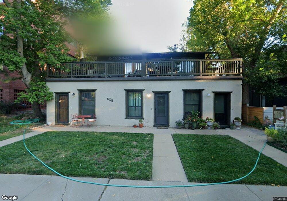
635 Walnut St Unit 1 Boulder, CO 80302
West Pearl NeighborhoodEstimated Value: $625,000 - $711,000
2
Beds
2
Baths
934
Sq Ft
$708/Sq Ft
Est. Value
About This Home
This home is located at 635 Walnut St Unit 1, Boulder, CO 80302 and is currently estimated at $661,720, approximately $708 per square foot. 635 Walnut St Unit 1 is a home located in Boulder County with nearby schools including Whittier Elementary School, Casey Middle School, and Boulder High School.
Ownership History
Date
Name
Owned For
Owner Type
Purchase Details
Closed on
Sep 25, 2002
Sold by
Beckerman Jeffrey M
Bought by
Seaman Judy W
Current Estimated Value
Purchase Details
Closed on
Oct 22, 1999
Sold by
Beckerman Jeffery M
Bought by
Beckerman Jeffrey M
Purchase Details
Closed on
Jan 19, 1993
Bought by
Seaman Judy W
Purchase Details
Closed on
Mar 2, 1990
Bought by
Seaman Judy W
Purchase Details
Closed on
May 6, 1988
Bought by
Seaman Judy W
Create a Home Valuation Report for This Property
The Home Valuation Report is an in-depth analysis detailing your home's value as well as a comparison with similar homes in the area
Home Values in the Area
Average Home Value in this Area
Purchase History
| Date | Buyer | Sale Price | Title Company |
|---|---|---|---|
| Seaman Judy W | -- | -- | |
| Beckerman Jeffrey M | -- | -- | |
| Seaman Judy W | $83,000 | -- | |
| Seaman Judy W | $61,000 | -- | |
| Seaman Judy W | -- | -- |
Source: Public Records
Tax History
| Year | Tax Paid | Tax Assessment Tax Assessment Total Assessment is a certain percentage of the fair market value that is determined by local assessors to be the total taxable value of land and additions on the property. | Land | Improvement |
|---|---|---|---|---|
| 2025 | $2,392 | $37,294 | -- | $37,294 |
| 2024 | $2,392 | $37,294 | -- | $37,294 |
| 2023 | $2,351 | $33,918 | -- | $37,603 |
| 2022 | $2,314 | $31,873 | $0 | $31,873 |
| 2021 | $2,207 | $32,790 | $0 | $32,790 |
| 2020 | $2,274 | $33,269 | $0 | $33,269 |
| 2019 | $2,239 | $33,269 | $0 | $33,269 |
| 2018 | $1,718 | $27,014 | $0 | $27,014 |
| 2017 | $2,269 | $29,866 | $0 | $29,866 |
| 2016 | $2,268 | $26,204 | $0 | $26,204 |
| 2015 | $2,148 | $22,240 | $0 | $22,240 |
| 2014 | $1,912 | $22,240 | $0 | $22,240 |
Source: Public Records
Map
Nearby Homes
- 620 Pearl St Unit C
- 545 Pearl St
- 780 Walnut St Unit A
- 854 Walnut St Unit D
- 613 Pine St
- 715 Arapahoe Ave Unit 2
- 934 Spruce St
- 745 Highland Ave
- 604 Mapleton Ave
- 465 Marine St
- 349 W Arapahoe Ln
- 1077 Canyon Blvd Unit 304
- 1077 Canyon Blvd Unit 305
- 1077 Canyon Blvd Unit 211
- 643 Mapleton Ave
- 944 Arapahoe Ave Unit A
- 944 Arapahoe Ave Unit B
- 2033 11th St Unit 3, 1
- 545 Mapleton Ave
- 1628 4th St
- 635 Walnut St Unit 4
- 635 Walnut St Unit 3
- 635 Walnut St Unit 2
- 624 Pearl St Unit 404
- 624 Pearl St Unit 403
- 624 Pearl St Unit 402
- 624 Pearl St Unit 401
- 624 Pearl St Unit 305
- 624 Pearl St Unit 304
- 624 Pearl St Unit 303
- 624 Pearl St Unit 302
- 624 Pearl St Unit 206
- 624 Pearl St Unit 204
- 624 Pearl St Unit 203
- 624 Pearl St Unit 202
- 624 Pearl St Unit 201
- 645 Walnut St
- 646 Pearl St
- 630 Pearl St
- 613 Walnut St
Your Personal Tour Guide
Ask me questions while you tour the home.