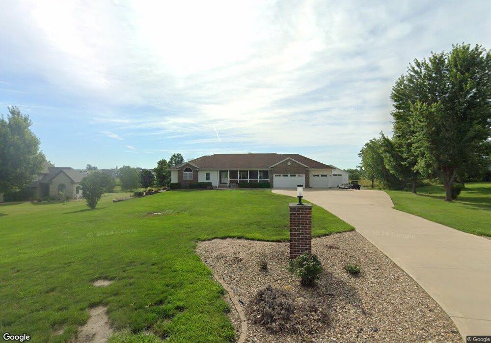
6351 White Gate Ct Marion, IA 52302
Estimated Value: $658,000 - $855,000
5
Beds
4
Baths
4,351
Sq Ft
$179/Sq Ft
Est. Value
About This Home
This home is located at 6351 White Gate Ct, Marion, IA 52302 and is currently estimated at $777,571, approximately $178 per square foot. 6351 White Gate Ct is a home located in Linn County with nearby schools including Novak Elementary School, Excelsior Middle School, and Linn-Mar High School.
Ownership History
Date
Name
Owned For
Owner Type
Purchase Details
Closed on
Sep 7, 2007
Sold by
Trca Kevin A and Trca Cindy Sue
Bought by
Little Paul D and Little Mary M
Current Estimated Value
Home Financials for this Owner
Home Financials are based on the most recent Mortgage that was taken out on this home.
Original Mortgage
$410,400
Outstanding Balance
$261,828
Interest Rate
6.72%
Mortgage Type
Purchase Money Mortgage
Estimated Equity
$515,743
Create a Home Valuation Report for This Property
The Home Valuation Report is an in-depth analysis detailing your home's value as well as a comparison with similar homes in the area
Home Values in the Area
Average Home Value in this Area
Purchase History
| Date | Buyer | Sale Price | Title Company |
|---|---|---|---|
| Little Paul D | $512,500 | None Available |
Source: Public Records
Mortgage History
| Date | Status | Borrower | Loan Amount |
|---|---|---|---|
| Open | Little Paul D | $410,400 |
Source: Public Records
Tax History Compared to Growth
Tax History
| Year | Tax Paid | Tax Assessment Tax Assessment Total Assessment is a certain percentage of the fair market value that is determined by local assessors to be the total taxable value of land and additions on the property. | Land | Improvement |
|---|---|---|---|---|
| 2025 | $8,322 | $689,200 | $136,000 | $553,200 |
| 2024 | $8,394 | $636,400 | $136,000 | $500,400 |
| 2023 | $8,394 | $636,400 | $136,000 | $500,400 |
| 2022 | $8,120 | $543,300 | $136,000 | $407,300 |
| 2021 | $7,926 | $543,300 | $136,000 | $407,300 |
| 2020 | $7,926 | $493,300 | $91,000 | $402,300 |
| 2019 | $7,376 | $461,800 | $91,000 | $370,800 |
| 2018 | $7,044 | $461,800 | $91,000 | $370,800 |
| 2017 | $6,968 | $442,200 | $91,000 | $351,200 |
| 2016 | $6,929 | $442,200 | $91,000 | $351,200 |
| 2015 | $6,981 | $442,200 | $91,000 | $351,200 |
| 2014 | $6,844 | $442,200 | $91,000 | $351,200 |
| 2013 | $6,572 | $442,200 | $91,000 | $351,200 |
Source: Public Records
Map
Nearby Homes
- 1605 Valentine Dr
- 1727 Hunters Creek Way Unit 1727
- 1789 Glen Rock Cir
- 1845 Hunters Creek Way Unit 1845
- 1600 Hunters Creek Way Unit 1600
- 1823 Glen Rock Cir
- 1562 Hunters Creek Way Unit 1562
- 2239 Royal Oak Ridge Rd
- 2027 Royal Oak Ridge Rd
- 2069 Royal Oak Ridge Rd
- 2155 Royal Oak Ridge Rd
- 1350 Huntington Hills Dr
- 2070 Royal Oak Ridge Rd
- 5524 Cimarron Ct
- 5510 Hunters Ridge Ct
- 2935 Clubhouse Dr
- 2933 Clubhouse Dr and 2935
- 2933 Clubhouse Dr
- 2970 Covey Run Ct
- 1698 Foxborough Dr
- 6401 White Gate Ct
- 6241 White Gate Ct Unit Outlot A
- 6451 White Gate Ct
- 6450 White Gate Ct
- 6400 White Gate Ct
- 6300 White Gate Ct
- 6501 White Gate Ct
- 6500 White Gate Ct
- 6551 White Gate Ct
- 6550 White Gate Ct
- 1475 Valentine Cir
- 1485 Valentine Cir
- 1495 Valentine Cir
- 1497 Glen Rock Cir
- 6601 White Gate Ct
- 1465 Valentine Cir
- 1515 Glen Rock Cir
- 6310 N 10th St
- 1505 Valentine Cir
- 6404 N 10th St