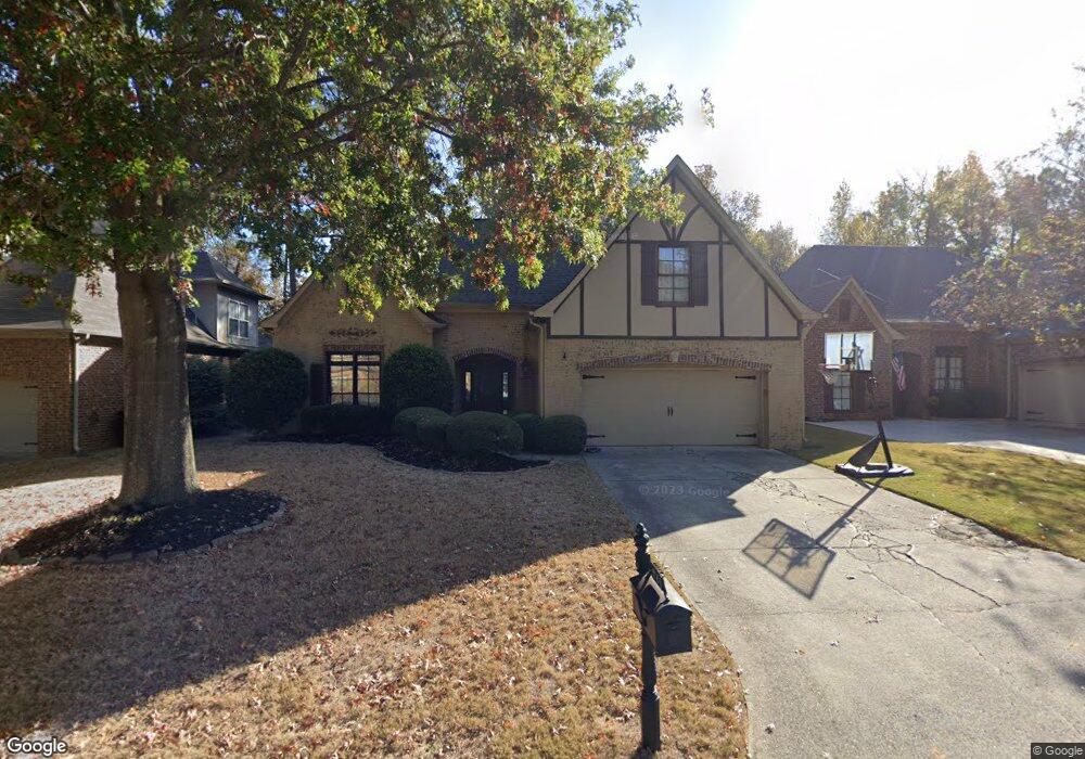
636 Talon Trace Unit 10 Birmingham, AL 35242
Estimated Value: $442,000 - $495,000
4
Beds
3
Baths
2,468
Sq Ft
$192/Sq Ft
Est. Value
About This Home
This home is located at 636 Talon Trace Unit 10, Birmingham, AL 35242 and is currently estimated at $474,448, approximately $192 per square foot. 636 Talon Trace Unit 10 is a home located in Shelby County with nearby schools including Oak Mountain Elementary School, Oak Mountain Intermediate School, and Oak Mt. Middle School.
Ownership History
Date
Name
Owned For
Owner Type
Purchase Details
Closed on
Apr 11, 2013
Sold by
Fannie Mae
Bought by
Powell John and Powell Kathy
Current Estimated Value
Purchase Details
Closed on
Oct 15, 2012
Sold by
Bush Letessia F and Bush Johnny M
Bought by
Federal National Mortgage Association
Purchase Details
Closed on
Jun 5, 2010
Sold by
Bush Johnny Mack
Bought by
Bush Letessia
Purchase Details
Closed on
Sep 13, 2002
Sold by
Nsh Corp
Bought by
Marriner Michelle
Home Financials for this Owner
Home Financials are based on the most recent Mortgage that was taken out on this home.
Original Mortgage
$190,750
Interest Rate
6.4%
Create a Home Valuation Report for This Property
The Home Valuation Report is an in-depth analysis detailing your home's value as well as a comparison with similar homes in the area
Home Values in the Area
Average Home Value in this Area
Purchase History
| Date | Buyer | Sale Price | Title Company |
|---|---|---|---|
| Powell John | $256,500 | None Available | |
| Federal National Mortgage Association | $288,000 | None Available | |
| Bush Letessia | -- | None Available | |
| Marriner Michelle | $211,946 | -- |
Source: Public Records
Mortgage History
| Date | Status | Borrower | Loan Amount |
|---|---|---|---|
| Previous Owner | Marriner Michelle | $190,750 |
Source: Public Records
Tax History Compared to Growth
Tax History
| Year | Tax Paid | Tax Assessment Tax Assessment Total Assessment is a certain percentage of the fair market value that is determined by local assessors to be the total taxable value of land and additions on the property. | Land | Improvement |
|---|---|---|---|---|
| 2024 | $1,861 | $42,300 | $0 | $0 |
| 2023 | $1,736 | $40,380 | $0 | $0 |
| 2022 | $1,667 | $38,820 | $0 | $0 |
| 2021 | $1,451 | $33,920 | $0 | $0 |
| 2020 | $1,311 | $30,720 | $0 | $0 |
| 2019 | $1,264 | $29,660 | $0 | $0 |
| 2017 | $1,226 | $28,800 | $0 | $0 |
| 2015 | $1,171 | $27,540 | $0 | $0 |
| 2014 | $1,143 | $26,900 | $0 | $0 |
Source: Public Records
Map
Nearby Homes
- 701 Talon Cove
- 4449 Eagle Point Dr
- 164 Bridge Dr
- 826 Griffin Park Cir
- 4524 Eagle Point Dr
- 1 Buckhorn Valley Dr
- 1224 Hunters Gate Dr
- 825 Greystone Highlands Dr
- 501 Talon Ct
- 4713 Eagle Wood Ct
- 4700 Eagle Wood Ct
- 239 Highland View Dr Unit 625
- 6012 Eagle Point Cir
- 420 Eaton Rd
- 102 Crest Rd
- 157 Highland View Dr Unit 439
- 149 Highland View Dr Unit 440
- 2024 Eaton Place
- 2028 Eaton Place
- 2032 Eaton Place
- 636 Talon Trace
- 632 Talon Trace
- 640 Talon Trace
- 628 Talon Trace
- 646 Talon Trace
- 635 Talon Trace
- 624 Talon Trace
- 639 Talon Trace
- 631 Talon Trace
- 650 Talon Trace
- 643 Talon Trace
- 627 Talon Trace
- 649 Talon Trace
- 618 Talon Trace
- 654 Talon Trace
- 654 Talon Trace Unit TRC
- 623 Talon Trace
- 924 Talon Way
- 928 Talon Way
- 920 Talon Way