L
Seller's Agent in 2026
Lydia Kirkland Pope
E & D Realty & Investment Co.
(216) 551-2500
1 in this area
53 Total Sales
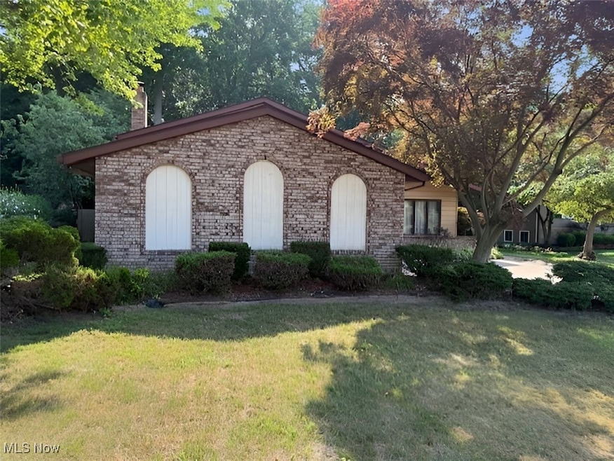


Enter this wonderful split-level home, where comfort and convenience come together seamlessly. The inviting living room welcomes you with warm natural light and features a sliding glass door that leads directly to a generous 43-foot-by-17-foot deck—a perfect space for relaxing, hosting gatherings, or enjoying quiet evenings outdoors. Beyond the deck, you'll find a 32-foot-by-16-foot heated in-ground pool, ideal for swimming, lounging, and making the most of warm summer days. The fully fenced yard offers privacy and security, creating an ideal setting for pets, children, and outdoor entertaining. With its blend of indoor charm and exceptional outdoor amenities, this home is a standout opportunity for anyone seeking comfort, style, and year-round enjoyment. Whether you're looking to entertain or simply unwind, this property delivers the space and features to match your lifestyle.
Last Agent to Sell the Property
E & D Realty & Investment Co. Brokerage Email: lydiapope88@gmail.com, 216-551-2500 License #415096 Listed on: 11/21/2025
Co-Listed By
E & D Realty & Investment Co. Brokerage Email: lydiapope88@gmail.com, 216-551-2500 License #2021007161
| Date | Type | Sale Price | Title Company |
|---|---|---|---|
| Special Warranty Deed | $275,000 | None Listed On Document | |
| Sheriffs Deed | $259,237 | None Listed On Document | |
| Warranty Deed | $194,000 | Realty Title | |
| Survivorship Deed | $170,000 | Main Street Title Agency Inc | |
| Deed | $149,900 | -- |
| Date | Status | Loan Amount | Loan Type |
|---|---|---|---|
| Open | $266,750 | New Conventional | |
| Previous Owner | $155,200 | Purchase Money Mortgage | |
| Previous Owner | $161,500 | No Value Available | |
| Closed | $19,400 | No Value Available |
| Date | Event | Price | List to Sale | Price per Sq Ft |
|---|---|---|---|---|
| 02/10/2026 02/10/26 | Sold | $275,000 | +1.9% | $112 / Sq Ft |
| 01/26/2026 01/26/26 | Pending | -- | -- | -- |
| 12/18/2025 12/18/25 | Price Changed | $270,000 | -3.5% | $110 / Sq Ft |
| 11/21/2025 11/21/25 | For Sale | $279,900 | -- | $114 / Sq Ft |
| Year | Tax Paid | Tax Assessment Tax Assessment Total Assessment is a certain percentage of the fair market value that is determined by local assessors to be the total taxable value of land and additions on the property. | Land | Improvement |
|---|---|---|---|---|
| 2025 | $2,355 | $87,710 | $20,950 | $66,760 |
| 2024 | -- | $87,710 | $20,950 | $66,760 |
| 2023 | -- | $75,890 | $17,160 | $58,730 |
| 2022 | $3,588 | $75,890 | $17,160 | $58,730 |
| 2021 | $3,639 | $75,890 | $17,160 | $58,730 |
| 2020 | $3,470 | $64,320 | $14,550 | $49,770 |
| 2019 | $3,736 | $64,320 | $14,550 | $49,770 |
| 2018 | $3,552 | $55,890 | $20,970 | $34,920 |
| 2017 | $3,160 | $55,890 | $20,970 | $34,920 |
| 2016 | $3,139 | $55,890 | $20,970 | $34,920 |
| 2015 | $2,802 | $55,890 | $20,970 | $34,920 |
| 2014 | $2,762 | $54,300 | $20,970 | $33,330 |
| 2013 | $2,765 | $54,300 | $20,970 | $33,330 |
L
Seller's Agent in 2026
Lydia Kirkland Pope
E & D Realty & Investment Co.
(216) 551-2500
1 in this area
53 Total Sales
L
Seller Co-Listing Agent in 2026
LeNard Pope
E & D Realty & Investment Co.
(216) 527-3387
1 in this area
20 Total Sales

Buyer's Agent in 2026
Denise Quiggle
McDowell Homes Real Estate Services
(440) 251-9985
34 in this area
399 Total Sales
Buyer Co-Listing Agent in 2026
Annette Marra
McDowell Homes Real Estate Services
(440) 665-7176
9 in this area
143 Total Sales
Source: MLS Now
MLS Number: 5173573
APN: 16-C-080-M-00-054-0
Disclaimer: Certain information contained herein is derived from information provided by parties other than Homes.com. All information provided is deemed reliable, but is not guaranteed to be accurate and should be independently verified.
![]() IDX information is provided exclusively for personal, non-commercial use, and may not be used for any purpose other than to identify prospective properties consumers may be interested in purchasing. Information is deemed reliable but not guaranteed.
IDX information is provided exclusively for personal, non-commercial use, and may not be used for any purpose other than to identify prospective properties consumers may be interested in purchasing. Information is deemed reliable but not guaranteed.
Ask me questions while you tour the home.