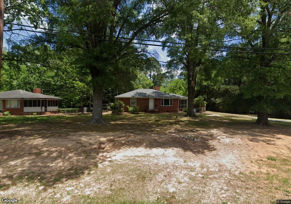
637 Morreene Rd Durham, NC 27705
West Durham NeighborhoodEstimated Value: $318,352 - $401,000
2
Beds
1
Bath
1,200
Sq Ft
$291/Sq Ft
Est. Value
About This Home
This home is located at 637 Morreene Rd, Durham, NC 27705 and is currently estimated at $349,088, approximately $290 per square foot. 637 Morreene Rd is a home located in Durham County with nearby schools including Morehead Montessori, Forest View Elementary, and Brogden Middle.
Ownership History
Date
Name
Owned For
Owner Type
Purchase Details
Closed on
Feb 6, 2024
Sold by
Dawson Robert Wayne
Bought by
City Of Durham
Current Estimated Value
Purchase Details
Closed on
Nov 18, 2019
Sold by
Vanderbilt Clara E
Bought by
Dawson Robert Wayne
Purchase Details
Closed on
Jul 3, 2001
Sold by
Boyd James P and Boyd Sharon P
Bought by
Vanderbilt Clara E
Create a Home Valuation Report for This Property
The Home Valuation Report is an in-depth analysis detailing your home's value as well as a comparison with similar homes in the area
Home Values in the Area
Average Home Value in this Area
Purchase History
| Date | Buyer | Sale Price | Title Company |
|---|---|---|---|
| City Of Durham | $2,500 | None Listed On Document | |
| Dawson Robert Wayne | -- | None Available | |
| Vanderbilt Clara E | $105,000 | -- |
Source: Public Records
Tax History
| Year | Tax Paid | Tax Assessment Tax Assessment Total Assessment is a certain percentage of the fair market value that is determined by local assessors to be the total taxable value of land and additions on the property. | Land | Improvement |
|---|---|---|---|---|
| 2025 | $3,153 | $318,052 | $137,700 | $180,352 |
| 2024 | $2,102 | $150,679 | $45,960 | $104,719 |
| 2023 | $1,974 | $150,679 | $45,960 | $104,719 |
| 2022 | $1,929 | $150,679 | $45,960 | $104,719 |
| 2021 | $1,920 | $150,679 | $45,960 | $104,719 |
| 2020 | $1,874 | $150,679 | $45,960 | $104,719 |
| 2019 | $1,874 | $150,679 | $45,960 | $104,719 |
| 2018 | $1,748 | $128,882 | $30,640 | $98,242 |
| 2017 | $1,735 | $128,882 | $30,640 | $98,242 |
| 2016 | $1,677 | $128,882 | $30,640 | $98,242 |
| 2015 | $1,403 | $101,317 | $32,739 | $68,578 |
| 2014 | $1,403 | $101,317 | $32,739 | $68,578 |
Source: Public Records
Map
Nearby Homes
- 512 Soapstone Dr
- 504 Soapstone Dr
- 508 Soapstone Dr
- 516 Soapstone Dr
- 409 Morreene Rd
- 10 Forest Oaks Dr
- 300 Vincent Ave
- 929 Morreene Rd Unit A23
- 74 Forest Oaks Dr
- 10 Sunrise Place
- 50 Galway Glenn Ln
- 219 Silas St
- 4111 Talcott Dr
- 19 Providence Ct
- 309 Lionel St
- 412 Lionel St
- 36 Georgetown Ct
- 4122 Westfield Dr
- 128 Galway Glenn Ln
- 710 Constitution Dr Unit 206
- 633 Morreene Rd
- 408 Andrews Rd
- 631 Morreene Rd Unit 2 Story
- 634 Starmont Dr
- 630 Starmont Dr
- 638 Starmont Dr
- 623 Morreene Rd
- 626 Starmont Dr
- 619 Morreene Rd
- 622 Starmont Dr
- 622 Morreene Rd
- 633 Starmont Dr
- 637 Starmont Dr
- 629 Starmont Dr
- 810 Morreene Rd Unit No Access
- 900 Morreene Rd Unit No Access
- 302 Morreene Rd
- 626 Morreene Rd
- 900 Morreene Rd
- 810 Morreene Rd
Your Personal Tour Guide
Ask me questions while you tour the home.