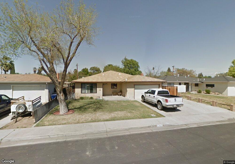
637 W Dennis Dr Clovis, CA 93612
Estimated Value: $344,000 - $394,000
3
Beds
2
Baths
1,735
Sq Ft
$212/Sq Ft
Est. Value
About This Home
This home is located at 637 W Dennis Dr, Clovis, CA 93612 and is currently estimated at $368,199, approximately $212 per square foot. 637 W Dennis Dr is a home located in Fresno County with nearby schools including Sierra Vista Elementary School, Clark Intermediate School, and Clovis High School.
Ownership History
Date
Name
Owned For
Owner Type
Purchase Details
Closed on
Aug 28, 2008
Sold by
National City Bank
Bought by
Ford Wayne M and Ford Karry C
Current Estimated Value
Home Financials for this Owner
Home Financials are based on the most recent Mortgage that was taken out on this home.
Original Mortgage
$162,050
Interest Rate
6.31%
Mortgage Type
FHA
Purchase Details
Closed on
Jun 19, 2008
Sold by
Gonzales Gabriel T and Gonzales Roxana H
Bought by
National City Bank
Purchase Details
Closed on
Nov 17, 2005
Sold by
Anderson Judith C
Bought by
Gonzales Gabriel T and Gonzales Roxana H
Home Financials for this Owner
Home Financials are based on the most recent Mortgage that was taken out on this home.
Original Mortgage
$213,600
Interest Rate
7%
Mortgage Type
Purchase Money Mortgage
Create a Home Valuation Report for This Property
The Home Valuation Report is an in-depth analysis detailing your home's value as well as a comparison with similar homes in the area
Home Values in the Area
Average Home Value in this Area
Purchase History
| Date | Buyer | Sale Price | Title Company |
|---|---|---|---|
| Ford Wayne M | $165,000 | First American Title | |
| National City Bank | $156,815 | Accommodation | |
| Gonzales Gabriel T | $267,000 | Fidelity National Title Co |
Source: Public Records
Mortgage History
| Date | Status | Borrower | Loan Amount |
|---|---|---|---|
| Previous Owner | Ford Wayne M | $162,050 | |
| Previous Owner | Gonzales Gabriel T | $213,600 |
Source: Public Records
Tax History
| Year | Tax Paid | Tax Assessment Tax Assessment Total Assessment is a certain percentage of the fair market value that is determined by local assessors to be the total taxable value of land and additions on the property. | Land | Improvement |
|---|---|---|---|---|
| 2025 | $2,435 | $211,823 | $77,259 | $134,564 |
| 2023 | $2,341 | $203,600 | $74,260 | $129,340 |
| 2022 | $2,308 | $199,608 | $72,804 | $126,804 |
| 2021 | $2,242 | $195,695 | $71,377 | $124,318 |
| 2020 | $2,233 | $193,690 | $70,646 | $123,044 |
| 2019 | $2,188 | $189,893 | $69,261 | $120,632 |
| 2018 | $2,139 | $186,170 | $67,903 | $118,267 |
| 2017 | $2,101 | $182,521 | $66,572 | $115,949 |
| 2016 | $2,029 | $178,943 | $65,267 | $113,676 |
| 2015 | $1,934 | $170,800 | $42,700 | $128,100 |
| 2014 | $1,810 | $152,000 | $55,500 | $96,500 |
Source: Public Records
Map
Nearby Homes
- 647 W Dennis Dr
- 1335 Cindy Ave
- 1314 Terry Ave
- 1629 Willow Ave
- 487 W San Jose Ave
- 1063 Pierce Dr
- 3600 W Shaw Ave
- 2110 Helm Ave Unit 19
- 1500 Villa Ave Unit 107
- 1500 Villa Ave Unit 170
- 1500 Villa Ave Unit 27
- 1500 Villa Ave Unit spc 7
- 1272 Villa Ave Unit 69
- 1272 Villa Ave Unit 76
- 1272 Villa Ave Unit SPC92
- 593 W Alamos Ave
- 1650 Villa Ave Unit 48
- 1001 Sylmar Ave Unit 3
- 1001 Sylmar Ave Unit 131
- 1001 Sylmar Ave Unit 99
- 627 W Dennis Dr
- 628 W Mitchell Ave
- 617 W Dennis Dr
- 618 W Mitchell Ave
- 628 W Dennis Dr
- 648 W Dennis Dr
- 607 W Dennis Dr
- 618 W Dennis Dr
- 1414 Helm Ave
- 1424 Helm Ave
- 608 W Mitchell Ave
- 658 W Dennis Dr
- 1404 Helm Ave
- 608 W Dennis Dr
- 1434 Helm Ave
- 597 W Dennis Dr
- 598 W Mitchell Ave
- 621 W Mitchell Ave
- 637 W Beverly Dr
- 627 W Beverly Dr
Your Personal Tour Guide
Ask me questions while you tour the home.