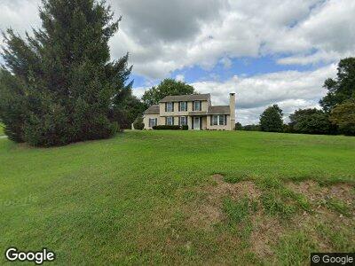
638 State Rd West Grove, PA 19390
Estimated Value: $402,000 - $466,000
3
Beds
3
Baths
2,032
Sq Ft
$212/Sq Ft
Est. Value
About This Home
This home is located at 638 State Rd, West Grove, PA 19390 and is currently estimated at $429,959, approximately $211 per square foot. 638 State Rd is a home located in Chester County with nearby schools including Penn London Elementary School, Avon Grove Intermediate School, and Fred S Engle Middle School.
Ownership History
Date
Name
Owned For
Owner Type
Purchase Details
Closed on
Mar 25, 1994
Sold by
Brodie David B and Brodie Anne Marie
Bought by
Kelly David M and Kelly Michelle L
Current Estimated Value
Home Financials for this Owner
Home Financials are based on the most recent Mortgage that was taken out on this home.
Original Mortgage
$148,400
Interest Rate
7.07%
Create a Home Valuation Report for This Property
The Home Valuation Report is an in-depth analysis detailing your home's value as well as a comparison with similar homes in the area
Home Values in the Area
Average Home Value in this Area
Purchase History
| Date | Buyer | Sale Price | Title Company |
|---|---|---|---|
| Kelly David M | $164,900 | -- |
Source: Public Records
Mortgage History
| Date | Status | Borrower | Loan Amount |
|---|---|---|---|
| Open | Kelly David M | $75,000 | |
| Open | Kelly David M | $140,000 | |
| Closed | Kelly David M | $155,000 | |
| Closed | Kelly David M | $148,400 |
Source: Public Records
Tax History Compared to Growth
Tax History
| Year | Tax Paid | Tax Assessment Tax Assessment Total Assessment is a certain percentage of the fair market value that is determined by local assessors to be the total taxable value of land and additions on the property. | Land | Improvement |
|---|---|---|---|---|
| 2024 | $6,331 | $155,350 | $40,640 | $114,710 |
| 2023 | $6,199 | $155,350 | $40,640 | $114,710 |
| 2022 | $6,109 | $155,350 | $40,640 | $114,710 |
| 2021 | $5,983 | $155,350 | $40,640 | $114,710 |
| 2020 | $5,784 | $155,350 | $40,640 | $114,710 |
| 2019 | $5,641 | $155,350 | $40,640 | $114,710 |
| 2018 | $5,498 | $155,350 | $40,640 | $114,710 |
| 2017 | $5,384 | $155,350 | $40,640 | $114,710 |
| 2016 | $4,343 | $155,350 | $40,640 | $114,710 |
| 2015 | $4,343 | $155,350 | $40,640 | $114,710 |
| 2014 | $4,343 | $155,350 | $40,640 | $114,710 |
Source: Public Records
Map
Nearby Homes
- 131 Marthas Way
- 781 W Glenview Dr
- 797 W Glenview Dr
- 154 Hillside Ave
- 17 Nottingham Dr
- 65 Kent Farm Ln
- 400 N Guernsey Rd
- 6 White Clay Ln
- 136 Janine Way
- 460 Pennocks Bridge Rd
- 85 Janine Way Unit HAWTHORNE
- 85 Janine Way Unit NOTTINGHAM
- 85 Janine Way Unit AUGUSTA
- 85 Janine Way Unit ANDREWS
- 85 Janine Way Unit DEVONSHIRE
- 230 N Jennersville Rd
- 225 State Rd
- 330 School Rd
- 103 Dylan Cir
- 607 Martin Dr