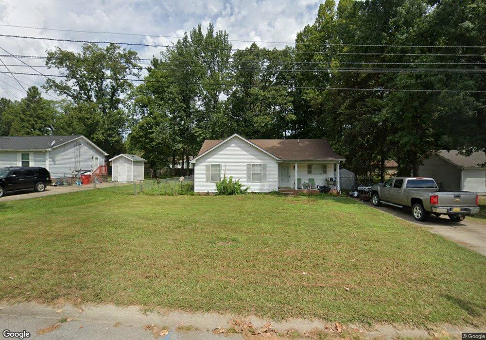
639 Miles Ct Clarksville, TN 37042
Estimated Value: $196,684 - $237,000
--
Bed
2
Baths
1,145
Sq Ft
$191/Sq Ft
Est. Value
About This Home
This home is located at 639 Miles Ct, Clarksville, TN 37042 and is currently estimated at $218,921, approximately $191 per square foot. 639 Miles Ct is a home located in Montgomery County with nearby schools including Liberty Elementary School, New Providence Middle School, and Northwest High School.
Ownership History
Date
Name
Owned For
Owner Type
Purchase Details
Closed on
Aug 13, 2002
Sold by
Department Of Housing & Ur
Bought by
Troy Daniel
Current Estimated Value
Purchase Details
Closed on
Feb 1, 2002
Sold by
Tenn Housing Development A
Bought by
Sec Of Housing & Urban Dev
Purchase Details
Closed on
Oct 9, 2001
Sold by
Small Daniel W
Bought by
Tenn Housing Agency
Purchase Details
Closed on
Oct 27, 1999
Sold by
Jones James D
Bought by
Kevin Nesbitt
Purchase Details
Closed on
Nov 18, 1993
Sold by
Alamo Real Estate & Insura
Bought by
Jones James D
Create a Home Valuation Report for This Property
The Home Valuation Report is an in-depth analysis detailing your home's value as well as a comparison with similar homes in the area
Home Values in the Area
Average Home Value in this Area
Purchase History
| Date | Buyer | Sale Price | Title Company |
|---|---|---|---|
| Troy Daniel | $55,800 | -- | |
| Sec Of Housing & Urban Dev | -- | -- | |
| Tenn Housing Agency | $68,557 | -- | |
| Kevin Nesbitt | $64,500 | -- | |
| Jones James D | $58,000 | -- |
Source: Public Records
Tax History Compared to Growth
Tax History
| Year | Tax Paid | Tax Assessment Tax Assessment Total Assessment is a certain percentage of the fair market value that is determined by local assessors to be the total taxable value of land and additions on the property. | Land | Improvement |
|---|---|---|---|---|
| 2024 | $1,513 | $50,775 | $0 | $0 |
| 2023 | $1,513 | $25,625 | $0 | $0 |
| 2022 | $1,081 | $25,625 | $0 | $0 |
| 2021 | $1,081 | $25,625 | $0 | $0 |
| 2020 | $1,030 | $25,625 | $0 | $0 |
| 2019 | $1,030 | $25,625 | $0 | $0 |
| 2018 | $1,004 | $19,050 | $0 | $0 |
| 2017 | $289 | $23,275 | $0 | $0 |
| 2016 | $715 | $23,275 | $0 | $0 |
| 2015 | $981 | $23,275 | $0 | $0 |
| 2014 | $968 | $23,275 | $0 | $0 |
| 2013 | $1,027 | $23,450 | $0 | $0 |
Source: Public Records
Map
Nearby Homes
- 524 Inver Ln
- 567 Matthew Ct
- 571 Donna Dr
- 554 Roselawn Dr
- 634 Inver Ln
- 573 Donna Dr
- 605 Marigold Dr
- 548 Buckeye Ln
- 616 Liberty Park
- 544 Roselawn Dr
- 541 Roselawn Dr
- 507 Medallion Cir
- 562 Medallion Cir
- 628 Wolfchase Dr
- 566 Bridgette Dr
- 640 Wolfchase Dr
- 614 Joshua Dr
- 587 Joshua Dr
- 411 Buckeye Ln
- 576 Cabot Cove