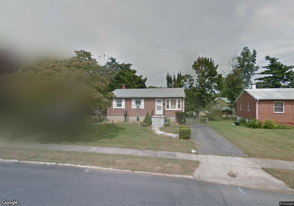
639 Shirley Dr Aberdeen, MD 21001
Estimated Value: $269,340 - $316,000
--
Bed
1
Bath
999
Sq Ft
$293/Sq Ft
Est. Value
About This Home
This home is located at 639 Shirley Dr, Aberdeen, MD 21001 and is currently estimated at $292,335, approximately $292 per square foot. 639 Shirley Dr is a home located in Harford County with nearby schools including Roye-Williams Elementary School, Aberdeen Middle School, and Aberdeen High School.
Ownership History
Date
Name
Owned For
Owner Type
Purchase Details
Closed on
Feb 8, 1996
Sold by
Tauson Richard A
Bought by
Haynes Willie C and Haynes Terrencia
Current Estimated Value
Purchase Details
Closed on
Dec 5, 1986
Sold by
Hopkins Warden T
Bought by
Tauson Richard A
Home Financials for this Owner
Home Financials are based on the most recent Mortgage that was taken out on this home.
Original Mortgage
$70,950
Interest Rate
9.3%
Create a Home Valuation Report for This Property
The Home Valuation Report is an in-depth analysis detailing your home's value as well as a comparison with similar homes in the area
Home Values in the Area
Average Home Value in this Area
Purchase History
| Date | Buyer | Sale Price | Title Company |
|---|---|---|---|
| Haynes Willie C | $94,800 | -- | |
| Tauson Richard A | $69,400 | -- |
Source: Public Records
Mortgage History
| Date | Status | Borrower | Loan Amount |
|---|---|---|---|
| Previous Owner | Tauson Richard A | $70,950 | |
| Closed | Haynes Willie C | -- |
Source: Public Records
Tax History Compared to Growth
Tax History
| Year | Tax Paid | Tax Assessment Tax Assessment Total Assessment is a certain percentage of the fair market value that is determined by local assessors to be the total taxable value of land and additions on the property. | Land | Improvement |
|---|---|---|---|---|
| 2025 | $1,712 | $193,900 | $0 | $0 |
| 2024 | $1,712 | $182,300 | $0 | $0 |
| 2023 | $1,627 | $170,700 | $63,000 | $107,700 |
| 2022 | $1,587 | $166,467 | $0 | $0 |
| 2021 | $1,589 | $162,233 | $0 | $0 |
| 2020 | $1,589 | $158,000 | $63,000 | $95,000 |
| 2019 | $1,583 | $157,433 | $0 | $0 |
| 2018 | $1,564 | $156,867 | $0 | $0 |
| 2017 | $1,558 | $156,300 | $0 | $0 |
| 2016 | -- | $156,300 | $0 | $0 |
| 2015 | $1,692 | $156,300 | $0 | $0 |
| 2014 | $1,692 | $173,500 | $0 | $0 |
Source: Public Records
Map
Nearby Homes
- 458 Roberts Way
- 650 Brenda Ln
- 606 Southgate Rd
- 35 Hillman Ct
- 735 Marian Dr
- 642 Westwood Dr
- 638 Westwood Dr
- 631 W Bel Air Ave
- 11 Bush Chapel Rd
- 21 Gunnison Dr
- 77 Baker St
- 73 Baker St
- 834 Gilbert Rd
- 724 Aldora Dr
- 197 Farm Rd
- 754 Custis St
- 753 Gilbert Rd
- 770 Custis St
- 3637 Dexter Ct Unit 158
- TBD-SOPHIE Dexter Ct
- 635 Shirley Dr
- 703 Shirley Dr
- 638 Beards Hill Rd
- 631 Shirley Dr
- 634 Beards Hill Rd
- 702 Beards Hill Rd
- 707 Shirley Dr
- 634 Shirley Dr
- 630 Beards Hill Rd
- 706 Beards Hill Rd
- 627 Shirley Dr
- 474 Bernice Terrace
- 630 Shirley Dr
- 626 Beards Hill Rd
- 710 Beards Hill Rd
- 469 Bernice Terrace
- 626 Shirley Dr
- 708 Shirley Dr
- 623 Shirley Dr
- 470 Bernice Terrace