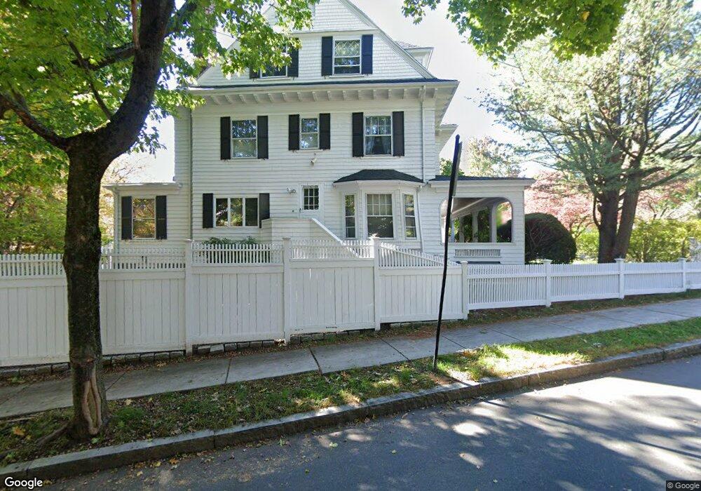
64 Dean Rd Brookline, MA 02445
Cleveland Circle NeighborhoodEstimated Value: $2,809,000 - $3,809,000
9
Beds
4
Baths
5,020
Sq Ft
$644/Sq Ft
Est. Value
About This Home
This home is located at 64 Dean Rd, Brookline, MA 02445 and is currently estimated at $3,230,419, approximately $643 per square foot. 64 Dean Rd is a home located in Norfolk County with nearby schools including John D. Runkle School, Torah Academy, and Maimonides School.
Ownership History
Date
Name
Owned For
Owner Type
Purchase Details
Closed on
Jan 28, 2015
Sold by
Moses Marsha A and Gardner Gerard F
Bought by
Moses Gardner Llc
Current Estimated Value
Purchase Details
Closed on
Oct 22, 1991
Sold by
Frist Financial Inc
Bought by
Gardner Gerard F
Purchase Details
Closed on
Oct 9, 1990
Sold by
Est Furst Jeffrey
Bought by
Coolidge Corner Coop
Create a Home Valuation Report for This Property
The Home Valuation Report is an in-depth analysis detailing your home's value as well as a comparison with similar homes in the area
Home Values in the Area
Average Home Value in this Area
Purchase History
| Date | Buyer | Sale Price | Title Company |
|---|---|---|---|
| Moses Gardner Llc | -- | -- | |
| Gardner Gerard F | $436,751 | -- | |
| Coolidge Corner Coop | $425,000 | -- |
Source: Public Records
Mortgage History
| Date | Status | Borrower | Loan Amount |
|---|---|---|---|
| Previous Owner | Coolidge Corner Coop | $250,000 | |
| Previous Owner | Coolidge Corner Coop | $214,600 | |
| Previous Owner | Coolidge Corner Coop | $100,000 |
Source: Public Records
Tax History Compared to Growth
Tax History
| Year | Tax Paid | Tax Assessment Tax Assessment Total Assessment is a certain percentage of the fair market value that is determined by local assessors to be the total taxable value of land and additions on the property. | Land | Improvement |
|---|---|---|---|---|
| 2025 | $27,213 | $2,757,100 | $1,436,500 | $1,320,600 |
| 2024 | $25,897 | $2,650,700 | $1,381,200 | $1,269,500 |
| 2023 | $23,181 | $2,325,100 | $986,800 | $1,338,300 |
| 2022 | $22,565 | $2,214,400 | $939,800 | $1,274,600 |
| 2021 | $20,867 | $2,129,300 | $903,700 | $1,225,600 |
| 2020 | $19,180 | $2,029,600 | $821,500 | $1,208,100 |
| 2019 | $18,112 | $1,933,000 | $782,400 | $1,150,600 |
| 2018 | $18,158 | $1,919,500 | $788,400 | $1,131,100 |
| 2017 | $17,920 | $1,813,800 | $743,700 | $1,070,100 |
| 2016 | $17,663 | $1,695,100 | $695,100 | $1,000,000 |
| 2015 | $16,919 | $1,584,200 | $649,600 | $934,600 |
| 2014 | $16,782 | $1,473,400 | $590,500 | $882,900 |
Source: Public Records
Map
Nearby Homes
- 333 Clark Rd
- 135 Beaconsfield Rd Unit 1
- 141 Beaconsfield Rd Unit 6
- 1763 Beacon St Unit A
- 94 Beaconsfield Rd Unit 201
- 1731 Beacon St Unit 717
- 1731 Beacon St Unit 1502
- 1778 Beacon St Unit 302
- 8 Strathmore Rd Unit G
- 324 Tappan St Unit 1
- 324 Tappan St Unit 2
- 3 Englewood Ave Unit 9
- 17 Strathmore Rd Unit 2
- 1856 Beacon St Unit 2C
- 9 Willard Rd
- 184 Rawson Rd
- 255 Tappan St
- 38 Kilsyth Rd Unit 21
- 1880 Beacon St Unit 6
- 37 Englewood Ave Unit 3