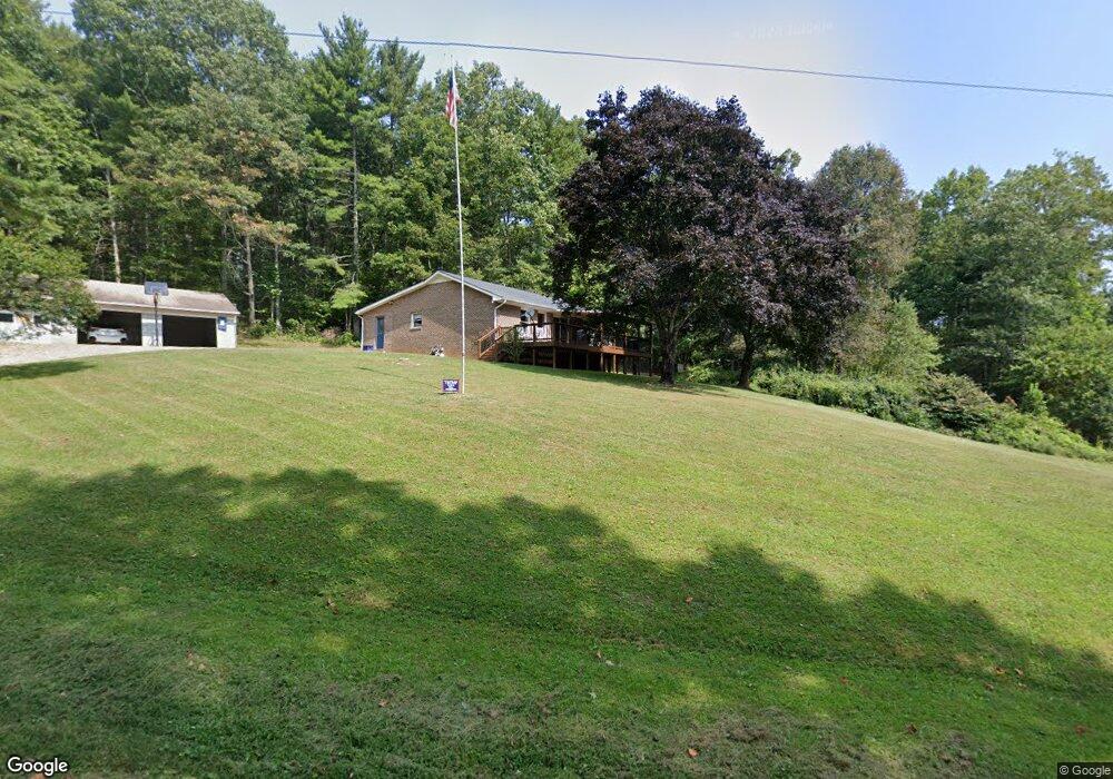
64 Dry Twig Rd Laurel Fork, VA 24352
Laurel Fork NeighborhoodEstimated Value: $148,000 - $265,000
Studio
--
Bath
--
Sq Ft
103,847
Sq Ft Lot
About This Home
This home is located at 64 Dry Twig Rd, Laurel Fork, VA 24352 and is currently estimated at $212,736. 64 Dry Twig Rd is a home located in Carroll County with nearby schools including Gladesboro Elementary School, Carroll County Middle School, and Carroll County High School.
Ownership History
Date
Name
Owned For
Owner Type
Purchase Details
Closed on
Aug 12, 2021
Sold by
Dalton Donnie and Dalton Susan Jane
Bought by
Dalton Jason Howard
Current Estimated Value
Home Financials for this Owner
Home Financials are based on the most recent Mortgage that was taken out on this home.
Original Mortgage
$111,928
Outstanding Balance
$101,929
Interest Rate
3%
Mortgage Type
New Conventional
Estimated Equity
$110,807
Purchase Details
Closed on
Apr 13, 2021
Sold by
Dalton Donnie and Dalton Susan Jane
Bought by
Dalton Jason Howard
Home Financials for this Owner
Home Financials are based on the most recent Mortgage that was taken out on this home.
Original Mortgage
$111,928
Interest Rate
3%
Mortgage Type
New Conventional
Purchase Details
Closed on
Jan 24, 2006
Sold by
Dalton Donnie and Dalton Susan Jane
Bought by
Dalton Jason Howard and Dalton Donnie
Create a Home Valuation Report for This Property
The Home Valuation Report is an in-depth analysis detailing your home's value as well as a comparison with similar homes in the area
Home Values in the Area
Average Home Value in this Area
Purchase History
| Date | Buyer | Sale Price | Title Company |
|---|---|---|---|
| Dalton Jason Howard | -- | Old Republic Natl Ttl Ins Co | |
| Dalton Jason Howard | -- | New Title Company Name | |
| Dalton Jason Howard | -- | New Title Company Name | |
| Dalton Jason Howard | -- | None Available |
Source: Public Records
Mortgage History
| Date | Status | Borrower | Loan Amount |
|---|---|---|---|
| Open | Dalton Jason Howard | $111,928 | |
| Previous Owner | Dalton Jason Howard | $111,928 |
Source: Public Records
Tax History
| Year | Tax Paid | Tax Assessment Tax Assessment Total Assessment is a certain percentage of the fair market value that is determined by local assessors to be the total taxable value of land and additions on the property. | Land | Improvement |
|---|---|---|---|---|
| 2025 | $852 | $173,800 | $23,900 | $149,900 |
| 2024 | $711 | $120,500 | $19,800 | $100,700 |
| 2023 | $711 | $120,500 | $19,800 | $100,700 |
| 2022 | $771 | $120,500 | $19,800 | $100,700 |
| 2021 | $771 | $120,500 | $19,800 | $100,700 |
| 2020 | $770 | $105,500 | $16,800 | $88,700 |
| 2019 | $733 | $105,500 | $16,800 | $88,700 |
| 2018 | $733 | $105,500 | $16,800 | $88,700 |
| 2017 | $733 | $105,500 | $16,800 | $88,700 |
| 2016 | $821 | $120,800 | $16,800 | $104,000 |
| 2015 | -- | $120,800 | $16,800 | $104,000 |
| 2014 | -- | $120,800 | $16,800 | $104,000 |
Source: Public Records
Map
Nearby Homes
- 487 Dry Twig Rd
- 0 Red Roof Ln
- TBD Lone Oak Ct
- 19 Lone Oak Ct
- TBD Fairlake Ln
- TBD Keno Rd
- 4306 Keno Rd
- TBD Blue Lake Ln
- 1205 Stone Mountain Rd
- 4655 Groundhog Mountain Rd
- 839 Excelsior School Rd
- TBD Excelsior School Rd
- 1533 Groundhog Mountain Rd
- 302 Cardinal Cir
- 608 Retreat Rd
- 69 Cabin Village Ln
- TBD Cabin Village Ln
- 538 Oakwood Rd
- 38 Dry Twig Rd
- 160 Dry Twig Rd
- 661 Oakwood Rd
- 374 Oakwood Rd
- 505 Oakwood Rd
- 216 Dry Twig Rd
- 789 Oakwood Rd
- 357 Dry Twig Rd
- 846 Oakwood Rd
- 4317 Keno Rd
- 363 Dry Twig Rd
- 147 Oakwood Rd
- TBD Worrell Memorial Rd
- 1235 Worrell Memorial Rd
- 0 Worrell Memorial Rd Unit 202642
- 0 Worrell Memorial Rd Unit 205204
- 0000 Worrell Memorial Rd
- 0 Worrell Memorial Rd Unit 100181
- 90 Pecan Hill
Your Personal Tour Guide
Ask me questions while you tour the home.