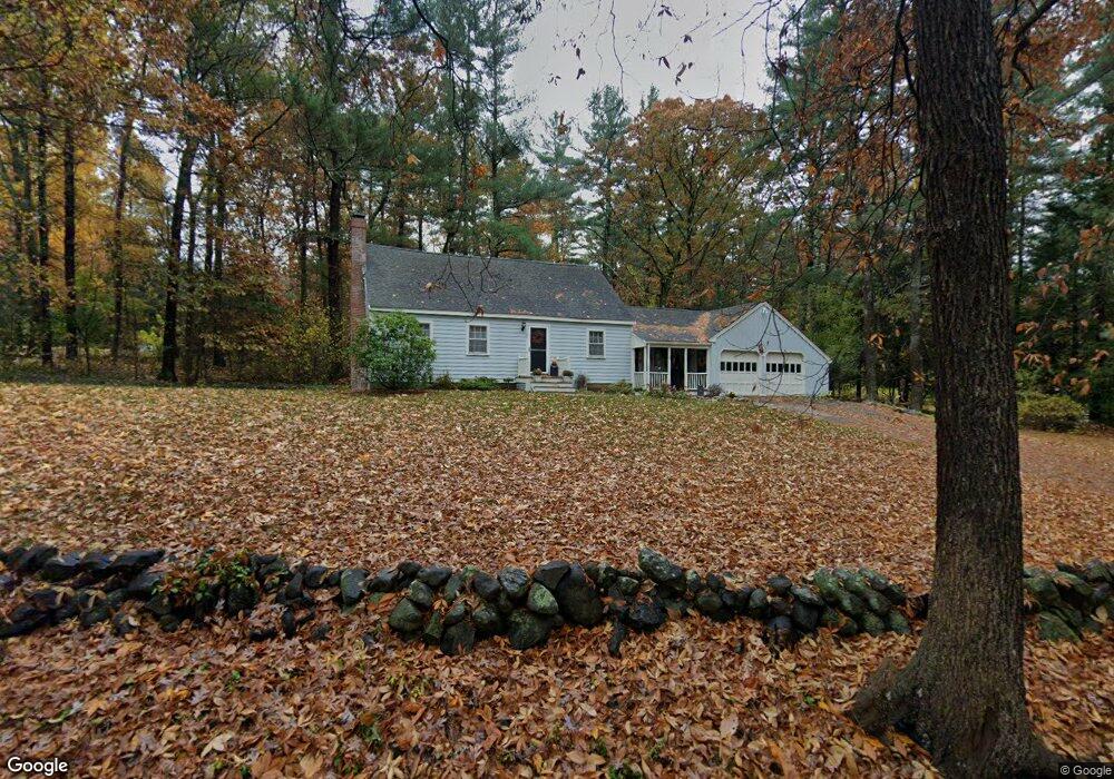
64 Old Right Rd Ipswich, MA 01938
Estimated Value: $707,909 - $756,000
3
Beds
2
Baths
1,710
Sq Ft
$426/Sq Ft
Est. Value
About This Home
This home is located at 64 Old Right Rd, Ipswich, MA 01938 and is currently estimated at $729,227, approximately $426 per square foot. 64 Old Right Rd is a home located in Essex County with nearby schools including Ipswich High School, Clark School, and North Shore Montessori School.
Ownership History
Date
Name
Owned For
Owner Type
Purchase Details
Closed on
Apr 5, 2007
Sold by
Santosuosso Karen A and Santosuosso Robert M
Bought by
Santosuosso Robert M
Current Estimated Value
Home Financials for this Owner
Home Financials are based on the most recent Mortgage that was taken out on this home.
Original Mortgage
$395,000
Interest Rate
6.25%
Mortgage Type
Purchase Money Mortgage
Purchase Details
Closed on
Mar 7, 2007
Sold by
Santosuosso Karen and Santosuosso Robert M
Bought by
Santosuosso Robert
Home Financials for this Owner
Home Financials are based on the most recent Mortgage that was taken out on this home.
Original Mortgage
$395,000
Interest Rate
6.25%
Mortgage Type
Purchase Money Mortgage
Purchase Details
Closed on
May 31, 1996
Sold by
Ruzanski Frederick P and Ruzanski Joanne
Bought by
Santosuosso Robert and Santosuosso Karen
Create a Home Valuation Report for This Property
The Home Valuation Report is an in-depth analysis detailing your home's value as well as a comparison with similar homes in the area
Home Values in the Area
Average Home Value in this Area
Purchase History
| Date | Buyer | Sale Price | Title Company |
|---|---|---|---|
| Santosuosso Robert M | -- | -- | |
| Santosuosso Robert | -- | -- | |
| Santosuosso Robert | $221,000 | -- |
Source: Public Records
Mortgage History
| Date | Status | Borrower | Loan Amount |
|---|---|---|---|
| Open | Santosuosso Robert | $382,300 | |
| Closed | Santosuosso Robert | $395,000 |
Source: Public Records
Tax History Compared to Growth
Tax History
| Year | Tax Paid | Tax Assessment Tax Assessment Total Assessment is a certain percentage of the fair market value that is determined by local assessors to be the total taxable value of land and additions on the property. | Land | Improvement |
|---|---|---|---|---|
| 2025 | $6,504 | $583,300 | $299,100 | $284,200 |
| 2024 | $6,380 | $560,600 | $297,700 | $262,900 |
| 2023 | $6,313 | $516,200 | $284,600 | $231,600 |
| 2022 | $6,332 | $492,400 | $284,600 | $207,800 |
| 2021 | $6,299 | $476,500 | $284,600 | $191,900 |
| 2020 | $6,207 | $442,700 | $258,500 | $184,200 |
| 2019 | $6,135 | $435,400 | $258,500 | $176,900 |
| 2018 | $6,159 | $432,500 | $262,900 | $169,600 |
| 2017 | $6,055 | $426,700 | $249,800 | $176,900 |
| 2016 | $5,906 | $397,700 | $236,700 | $161,000 |
| 2015 | $5,320 | $393,800 | $228,000 | $165,800 |
Source: Public Records
Map
Nearby Homes
- 29 Charlotte Rd
- 37 East St
- 43 Willowdale Rd
- 54 Willowdale Rd
- 4 Ruby Cir
- 8 Mansion Dr
- 14 Pond St
- 75 Country Club Way
- 46 Buttonwood
- 1 Court Ln
- 196 Country Club Way
- 16 Killam Hill Rd
- 8 Longmeadow Dr Unit 14
- 76-78 Daniels Rd
- 117 Perkins Row
- 16 Cedarwood Ln
- 58 Washington St
- 125 Topsfield Rd
- 18 Boxford Rd
- 53 Emily Ln