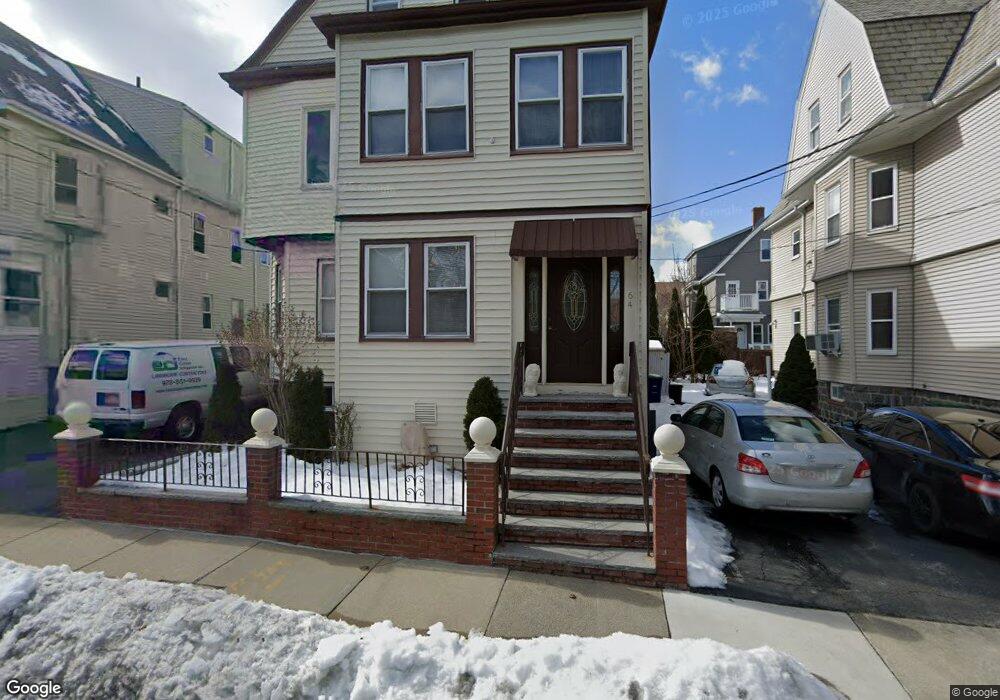
64 Pearson Rd Somerville, MA 02144
Estimated Value: $1,337,000 - $1,835,176
7
Beds
2
Baths
3,250
Sq Ft
$477/Sq Ft
Est. Value
About This Home
This home is located at 64 Pearson Rd, Somerville, MA 02144 and is currently estimated at $1,550,044, approximately $476 per square foot. 64 Pearson Rd is a home located in Middlesex County with nearby schools including Somerville High School, St. Clement Elementary School, and St. Joseph School.
Ownership History
Date
Name
Owned For
Owner Type
Purchase Details
Closed on
Mar 7, 2025
Sold by
Centofanti Pasquale
Bought by
Pasquale Centofanti T and Pasquale Centofanti
Current Estimated Value
Purchase Details
Closed on
Feb 22, 2018
Sold by
Centofanti Eva
Bought by
Centofanti Eva and Centofanti Pasquale
Purchase Details
Closed on
Feb 10, 2004
Sold by
Centofani Eva and Centofani Giuseppe
Bought by
Centofani Ft and Centofani
Purchase Details
Closed on
Jan 19, 1970
Bought by
Centofanti Giuseppe and Centofanti Eva
Create a Home Valuation Report for This Property
The Home Valuation Report is an in-depth analysis detailing your home's value as well as a comparison with similar homes in the area
Purchase History
| Date | Buyer | Sale Price | Title Company |
|---|---|---|---|
| Pasquale Centofanti T | -- | None Available | |
| Pasquale Centofanti T | -- | None Available | |
| Centofanti Eva | -- | -- | |
| Centofanti Eva | -- | -- | |
| Giuseppe Centofanti Lt | -- | -- | |
| Giuseppe Centofanti Lt | -- | -- | |
| Centofani Ft | -- | -- | |
| Centofani Ft | -- | -- | |
| Centofanti Giuseppe | $28,500 | -- |
Source: Public Records
Tax History
| Year | Tax Paid | Tax Assessment Tax Assessment Total Assessment is a certain percentage of the fair market value that is determined by local assessors to be the total taxable value of land and additions on the property. | Land | Improvement |
|---|---|---|---|---|
| 2025 | $15,586 | $1,428,600 | $715,000 | $713,600 |
| 2024 | $14,895 | $1,415,900 | $715,000 | $700,900 |
| 2023 | $14,139 | $1,367,400 | $715,000 | $652,400 |
| 2022 | $13,316 | $1,308,100 | $681,000 | $627,100 |
| 2021 | $12,924 | $1,268,300 | $676,000 | $592,300 |
| 2020 | $12,451 | $1,234,000 | $676,400 | $557,600 |
| 2019 | $11,775 | $1,094,300 | $615,800 | $478,500 |
| 2018 | $10,872 | $961,300 | $559,800 | $401,500 |
| 2017 | $10,396 | $890,800 | $528,100 | $362,700 |
| 2016 | $10,054 | $802,400 | $471,700 | $330,700 |
| 2015 | $9,626 | $763,400 | $435,600 | $327,800 |
Source: Public Records
Map
Nearby Homes
- 111 Pearson Rd
- 15 Colby St
- 228 Harvard St
- 1004 Broadway Unit 3
- 55 Packard Ave Unit 1
- 42 Packard Ave Unit 42
- 26 Chandler St Unit 26
- 69 Electric Ave Unit 3
- 68 Winslow Ave
- 74 Pearson Ave
- 43 Grove St
- 16 Rogers Ave
- 106 Electric Ave Unit 3
- 297 Main St Unit 3
- 595 Broadway Unit 302
- 595 Broadway Unit 102
- 595 Broadway Unit 202
- 595 Broadway Unit 101
- 595 Broadway Unit 301
- 288 Cedar St
- 64 Pearson Rd Unit 1
- 68 Pearson Rd
- 60 Pearson Rd
- 60 Pearson Rd Unit 2
- 37 Bromfield Rd
- 37 Bromfield Rd Unit 1
- 37 Bromfield Rd Unit 2
- 33 Bromfield Rd
- 33 Bromfield Rd Unit 2
- 33 Bromfield Rd Unit 1
- 33 Bromfield Rd
- 33 Bromfield Rd Unit 3
- 56 Pearson Rd
- 41 Bromfield Rd
- 72 Pearson Rd
- 72 Pearson Rd Unit 2
- 59 Pearson Rd
- 29 Bromfield Rd
- 29 Bromfield Rd Unit 29 Bromfield Rd U1
- 29 Bromfield Rd Unit 29 Bromfield Rd.
Your Personal Tour Guide
Ask me questions while you tour the home.