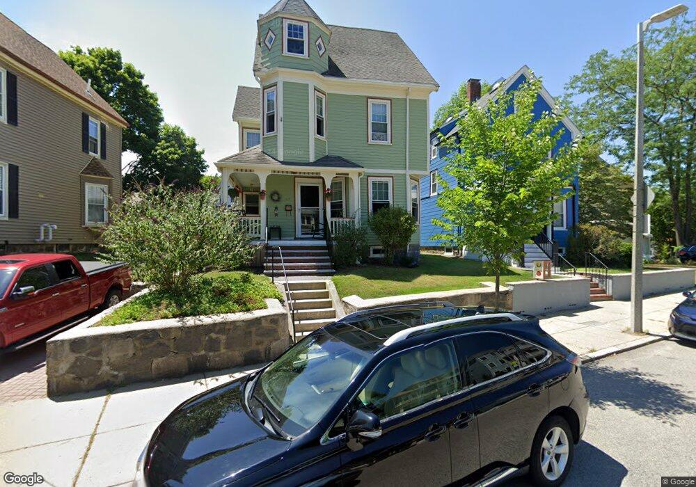
64 Robert St Roslindale, MA 02131
Roslindale NeighborhoodEstimated Value: $760,000 - $907,498
4
Beds
3
Baths
2,182
Sq Ft
$388/Sq Ft
Est. Value
About This Home
This home is located at 64 Robert St, Roslindale, MA 02131 and is currently estimated at $847,375, approximately $388 per square foot. 64 Robert St is a home located in Suffolk County with nearby schools including Brooke Charter School Roslindale, Holy Name Parish School, and Sacred Heart STEM School.
Ownership History
Date
Name
Owned For
Owner Type
Purchase Details
Closed on
Jan 17, 2013
Sold by
Dumas Gregory J and Mckeown Janice M
Bought by
Dumas Gregory J and Mckeown Janice M
Current Estimated Value
Home Financials for this Owner
Home Financials are based on the most recent Mortgage that was taken out on this home.
Original Mortgage
$352,500
Outstanding Balance
$245,323
Interest Rate
3.39%
Mortgage Type
New Conventional
Estimated Equity
$602,052
Purchase Details
Closed on
Dec 22, 1998
Sold by
Dumas Gregory J and Dumas Lynn P
Bought by
Dumas Gregory J
Home Financials for this Owner
Home Financials are based on the most recent Mortgage that was taken out on this home.
Original Mortgage
$120,000
Interest Rate
6.85%
Mortgage Type
Purchase Money Mortgage
Create a Home Valuation Report for This Property
The Home Valuation Report is an in-depth analysis detailing your home's value as well as a comparison with similar homes in the area
Home Values in the Area
Average Home Value in this Area
Purchase History
| Date | Buyer | Sale Price | Title Company |
|---|---|---|---|
| Dumas Gregory J | -- | -- | |
| Dumas Gregory J | $53,123 | -- |
Source: Public Records
Mortgage History
| Date | Status | Borrower | Loan Amount |
|---|---|---|---|
| Open | Dumas Gregory J | $352,500 | |
| Previous Owner | Dumas Gregory J | $160,000 | |
| Previous Owner | Dumas Gregory J | $120,000 | |
| Previous Owner | Dumas Gregory J | $80,000 |
Source: Public Records
Tax History
| Year | Tax Paid | Tax Assessment Tax Assessment Total Assessment is a certain percentage of the fair market value that is determined by local assessors to be the total taxable value of land and additions on the property. | Land | Improvement |
|---|---|---|---|---|
| 2025 | $7,764 | $670,500 | $192,700 | $477,800 |
| 2024 | $7,258 | $665,900 | $180,100 | $485,800 |
| 2023 | $7,168 | $667,400 | $180,100 | $487,300 |
| 2022 | $6,483 | $595,900 | $160,800 | $435,100 |
| 2021 | $6,364 | $596,400 | $162,400 | $434,000 |
| 2020 | $5,432 | $514,400 | $150,700 | $363,700 |
| 2019 | $5,020 | $476,300 | $127,700 | $348,600 |
| 2018 | $4,624 | $441,200 | $127,700 | $313,500 |
| 2017 | $4,672 | $441,200 | $127,700 | $313,500 |
| 2016 | $4,711 | $428,300 | $127,700 | $300,600 |
| 2015 | $4,425 | $365,400 | $115,500 | $249,900 |
| 2014 | $4,179 | $332,200 | $115,500 | $216,700 |
Source: Public Records
Map
Nearby Homes
- 15 S Fairview St Unit 3
- 18 Robert St Unit 4
- 18 Robert St Unit 14
- 11 S Fairview St Unit 2R
- 103 Belgrade Ave Unit 2
- 7 Basto Terrace
- 951 South St
- 46 Belgrade Ave Unit 2
- 26 Bradfield Ave Unit 3
- 92 Roslindale Ave
- 8 Kittredge St Unit 10
- 15 Hillock St Unit 2
- 6 Hayes Rd Unit 25
- 3 Rosemere Ct Unit 1
- 62 Ainsworth St
- 25 Hazelmere Rd
- 83 Newburg St Unit 1
- 1401 Centre St Unit 1401
- 2 Weld Hill St Unit PH2
- 167 Poplar St Unit 1
- 60 Robert St
- 68 Robert St
- 26 S Walter St
- 22 S Walter St
- 22 S Walter St Unit 3
- 56 Robert St
- 30 S Walter St
- 30 S Walter St Unit 2
- 30 S Walter St Unit 1
- 18 S Walter St
- 73 Robert St Unit 3
- 73 Robert St Unit 2
- 73 Robert St Unit 1
- 71 Robert St
- 73 Robert St Unit 1,73
- 61 Robert St Unit 63
- 63 Robert St
- 63 Robert St Unit 2
- 63 Roberts St Unit 2
- 61 Robert St Unit 2
Your Personal Tour Guide
Ask me questions while you tour the home.