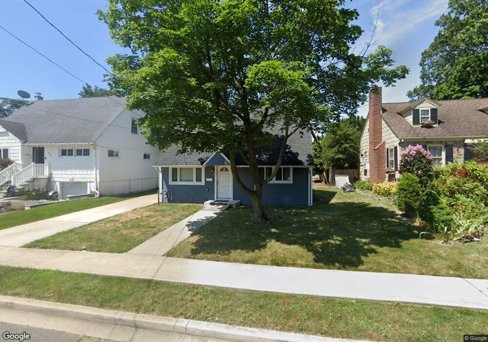
64 Saint Marks Ave Freeport, NY 11520
Estimated Value: $536,000 - $562,789
4
Beds
2
Baths
1,008
Sq Ft
$545/Sq Ft
Est. Value
About This Home
This home is located at 64 Saint Marks Ave, Freeport, NY 11520 and is currently estimated at $549,395, approximately $545 per square foot. 64 Saint Marks Ave is a home located in Nassau County with nearby schools including Columbus Avenue School, Caroline G. Atkinson Intermediate School, and John W Dodd Middle School.
Ownership History
Date
Name
Owned For
Owner Type
Purchase Details
Closed on
Feb 24, 2020
Sold by
Mph1 Llc
Bought by
Murphy Brendan J and Murphy Cheryl
Current Estimated Value
Home Financials for this Owner
Home Financials are based on the most recent Mortgage that was taken out on this home.
Original Mortgage
$303,750
Outstanding Balance
$268,501
Interest Rate
3.4%
Mortgage Type
New Conventional
Estimated Equity
$280,894
Purchase Details
Closed on
May 14, 2019
Sold by
Steinway Trust
Bought by
Mph1 Llc
Purchase Details
Closed on
Apr 30, 2013
Sold by
Steinway James J
Bought by
Steinway James J and The James J Steinway Revocable Trust
Create a Home Valuation Report for This Property
The Home Valuation Report is an in-depth analysis detailing your home's value as well as a comparison with similar homes in the area
Home Values in the Area
Average Home Value in this Area
Purchase History
| Date | Buyer | Sale Price | Title Company |
|---|---|---|---|
| Murphy Brendan J | -- | None Available | |
| Mph1 Llc | $210,000 | None Available | |
| Steinway James J | -- | -- |
Source: Public Records
Mortgage History
| Date | Status | Borrower | Loan Amount |
|---|---|---|---|
| Open | Murphy Brendan J | $303,750 |
Source: Public Records
Tax History
| Year | Tax Paid | Tax Assessment Tax Assessment Total Assessment is a certain percentage of the fair market value that is determined by local assessors to be the total taxable value of land and additions on the property. | Land | Improvement |
|---|---|---|---|---|
| 2025 | $6,792 | $315 | $145 | $170 |
| 2024 | $740 | $325 | $150 | $175 |
Source: Public Records
Map
Nearby Homes
- 48 Saint Marks Ave
- 403 S Bayview Ave
- 119 S Bay Ave
- 173 Cedar St
- 463 S Bayview Ave
- 158 Roosevelt Ave
- 265 Roosevelt Ave
- 267 Roosevelt Ave
- 160 Saint Marks Ave
- 153 Westend Ave
- 525 Ray St
- 311 Park Ave
- 31 Anchor St Unit Y
- 116 Westend Ave Unit 8
- 268 Locust Ave
- 135 Whaley St
- 306 Park Ave
- 310 Miller Ave
- 47 Anchor St Unit Y
- 210 Westend Ave Unit 8B
- 64 St Marks Ave
- 74 Saint Marks Ave
- 62 Saint Marks Ave
- 31 Branch Ave
- 78 Saint Marks Ave
- 58 Saint Marks Ave
- 35 Branch Ave
- 27 Branch Ave
- 39 Branch Ave
- 63 Saint Marks Ave
- 67 Saint Marks Ave
- 82 Saint Marks Ave
- 54 Saint Marks Ave
- 23 Branch Ave
- 59 Saint Marks Ave
- 43 Branch Ave
- 71 Saint Marks Ave
- 55 Saint Marks Ave
- 50 Saint Marks Ave
- 86 Saint Marks Ave
Your Personal Tour Guide
Ask me questions while you tour the home.