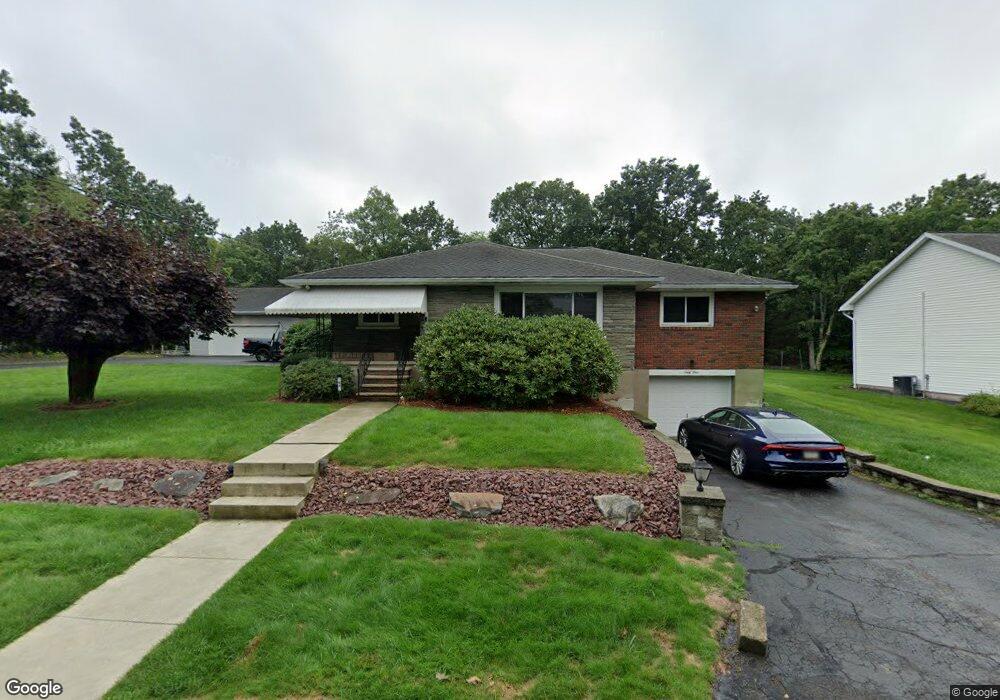
64 Snook St Scranton, PA 18505
East Mountain NeighborhoodEstimated Value: $239,493 - $283,000
2
Beds
2
Baths
1,880
Sq Ft
$144/Sq Ft
Est. Value
About This Home
This home is located at 64 Snook St, Scranton, PA 18505 and is currently estimated at $269,873, approximately $143 per square foot. 64 Snook St is a home located in Lackawanna County with nearby schools including John G. Whittier Elementary School, South Scranton Intermediate, and Scranton High School.
Ownership History
Date
Name
Owned For
Owner Type
Purchase Details
Closed on
Mar 1, 2023
Sold by
Whetsel Andrew
Bought by
Whetsel Andrew
Current Estimated Value
Purchase Details
Closed on
Jan 20, 2020
Sold by
Paskert Paul A and Paskert Colleen M
Bought by
Whetsel Andrew
Home Financials for this Owner
Home Financials are based on the most recent Mortgage that was taken out on this home.
Original Mortgage
$247,926
Interest Rate
3.37%
Mortgage Type
FHA
Purchase Details
Closed on
Dec 3, 2010
Sold by
Paskert Paul A and Paskert Colleen
Bought by
Paskert Paul A and Paskert Colleen
Home Financials for this Owner
Home Financials are based on the most recent Mortgage that was taken out on this home.
Original Mortgage
$179,000
Interest Rate
3.68%
Mortgage Type
New Conventional
Create a Home Valuation Report for This Property
The Home Valuation Report is an in-depth analysis detailing your home's value as well as a comparison with similar homes in the area
Home Values in the Area
Average Home Value in this Area
Purchase History
| Date | Buyer | Sale Price | Title Company |
|---|---|---|---|
| Whetsel Andrew | -- | None Listed On Document | |
| Whetsel Andrew | $252,500 | None Available | |
| Paskert Paul A | -- | None Available |
Source: Public Records
Mortgage History
| Date | Status | Borrower | Loan Amount |
|---|---|---|---|
| Previous Owner | Whetsel Andrew | $247,926 | |
| Previous Owner | Paskert Paul A | $179,000 |
Source: Public Records
Tax History
| Year | Tax Paid | Tax Assessment Tax Assessment Total Assessment is a certain percentage of the fair market value that is determined by local assessors to be the total taxable value of land and additions on the property. | Land | Improvement |
|---|---|---|---|---|
| 2025 | $7,281 | $20,500 | $6,750 | $13,750 |
| 2024 | $6,700 | $20,500 | $6,750 | $13,750 |
| 2023 | $6,243 | $19,500 | $5,750 | $13,750 |
| 2022 | $6,107 | $19,500 | $5,750 | $13,750 |
| 2021 | $6,107 | $19,500 | $5,750 | $13,750 |
| 2020 | $6,003 | $19,500 | $5,750 | $13,750 |
| 2019 | $5,657 | $19,500 | $5,750 | $13,750 |
| 2018 | $5,657 | $19,500 | $5,750 | $13,750 |
| 2017 | $5,565 | $19,500 | $5,750 | $13,750 |
| 2016 | $2,032 | $19,500 | $5,750 | $13,750 |
| 2015 | $3,942 | $19,500 | $5,750 | $13,750 |
| 2014 | -- | $19,500 | $5,750 | $13,750 |
Source: Public Records
Map
Nearby Homes
- 80 Elmhurst Blvd
- 0 Silkman Ave
- 213 Karen Dr
- 837 Matthew Ave
- 218 Lake Scranton Rd
- 200 Sand St
- 615 Arthur Ave
- 617 Arthur Ave
- 1947 Myrtle St
- 619 Arthur Ave
- 0 Colfax Ave
- 7 Tiffany Dr
- 1050 Mark Ave
- 0 Colfax and Gibson Ave Unit GSBSC255175
- Lot A-1 Baldassari Dr
- 12 Baldassari Dr
- 810 Wheeler Ave
- 616-618 Harrison Ave
- 516 Harrison Ave
- 342 Harrison Ave
Your Personal Tour Guide
Ask me questions while you tour the home.