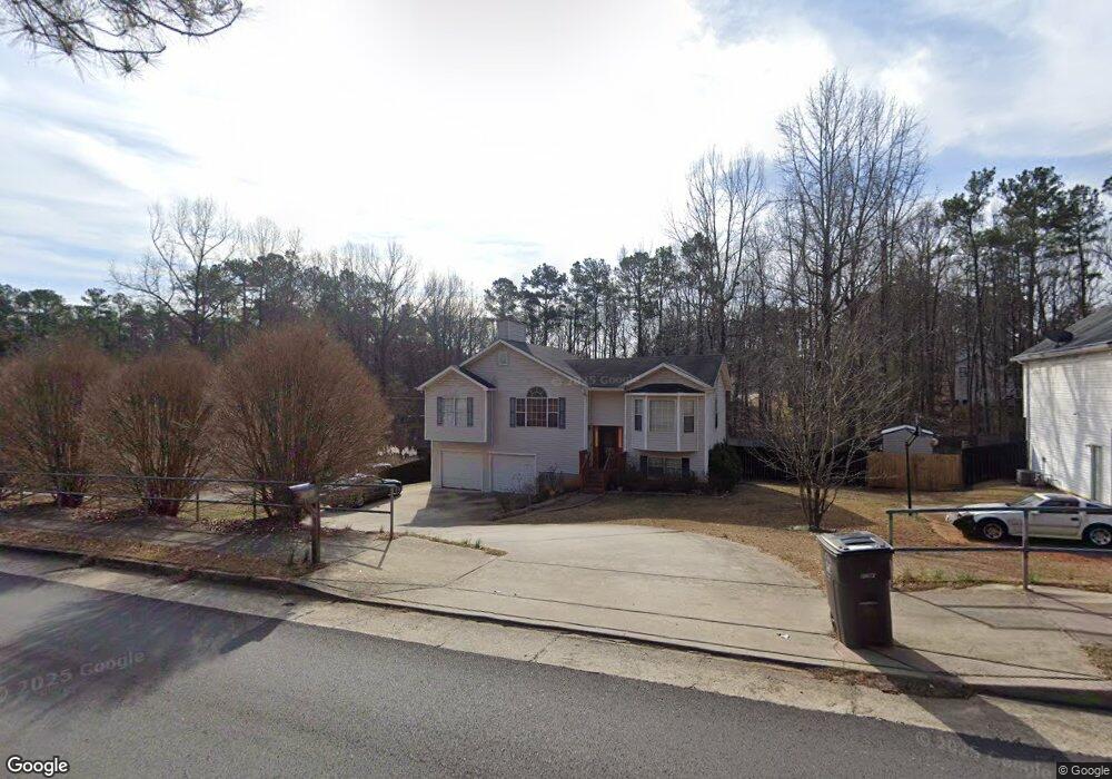
6403 Malone Rd Douglasville, GA 30134
Estimated Value: $239,382 - $289,000
3
Beds
2
Baths
1,230
Sq Ft
$211/Sq Ft
Est. Value
About This Home
This home is located at 6403 Malone Rd, Douglasville, GA 30134 and is currently estimated at $259,596, approximately $211 per square foot. 6403 Malone Rd is a home located in Douglas County with nearby schools including Burnett Elementary School, Stewart Middle School, and Douglas County High School.
Ownership History
Date
Name
Owned For
Owner Type
Purchase Details
Closed on
Jul 2, 2007
Sold by
Mixon Michael A and Mixon Angela D
Bought by
Hasley Elsa and Moody Monica
Current Estimated Value
Home Financials for this Owner
Home Financials are based on the most recent Mortgage that was taken out on this home.
Original Mortgage
$141,000
Outstanding Balance
$88,222
Interest Rate
6.52%
Mortgage Type
New Conventional
Estimated Equity
$171,374
Purchase Details
Closed on
Nov 26, 1996
Sold by
Buckner Jerry
Bought by
Mixon Michael Angela
Create a Home Valuation Report for This Property
The Home Valuation Report is an in-depth analysis detailing your home's value as well as a comparison with similar homes in the area
Home Values in the Area
Average Home Value in this Area
Purchase History
| Date | Buyer | Sale Price | Title Company |
|---|---|---|---|
| Hasley Elsa | $141,000 | -- | |
| Mixon Michael Angela | $86,900 | -- |
Source: Public Records
Mortgage History
| Date | Status | Borrower | Loan Amount |
|---|---|---|---|
| Open | Hasley Elsa | $141,000 | |
| Closed | Mixon Michael Angela | $0 |
Source: Public Records
Tax History Compared to Growth
Tax History
| Year | Tax Paid | Tax Assessment Tax Assessment Total Assessment is a certain percentage of the fair market value that is determined by local assessors to be the total taxable value of land and additions on the property. | Land | Improvement |
|---|---|---|---|---|
| 2024 | $2,070 | $57,240 | $8,400 | $48,840 |
| 2023 | $2,070 | $57,240 | $8,400 | $48,840 |
| 2022 | $2,001 | $57,240 | $8,400 | $48,840 |
| 2021 | $1,709 | $46,560 | $8,400 | $38,160 |
| 2020 | $1,744 | $46,560 | $8,400 | $38,160 |
| 2019 | $1,641 | $45,560 | $8,400 | $37,160 |
| 2018 | $1,623 | $44,560 | $8,400 | $36,160 |
| 2017 | $1,492 | $39,920 | $8,400 | $31,520 |
| 2016 | $1,469 | $38,720 | $8,400 | $30,320 |
| 2015 | $1,475 | $37,840 | $8,400 | $29,440 |
| 2014 | $1,293 | $34,240 | $8,400 | $25,840 |
| 2013 | -- | $34,160 | $8,400 | $25,760 |
Source: Public Records
Map
Nearby Homes
- 7712 Autry Cir Unit 617
- 7712 Autry Cir Unit 701
- 7712 Autry Cir Unit 7-721
- 7712 Autry Cir Unit 305
- 7687 Greenridge Ct
- 7835 Teton Trail Unit 1
- 6215 Grovener Ave
- 7420 Bristol Cir
- 6592 Malone Rd
- 6588 Snowbird Ln Unit 1
- 1160 Pleasant Oak Ln
- 7407 Stone Bluff Dr
- 1121 Grove Trail Pass
- 6292 Hampstead Ln
- 6615 Bluffview Dr
- 6298 Hampstead Ln
- 995 Old Dallas Hwy
- 6415 Malone Rd
- 6391 Malone Rd
- 6425 Malone Rd
- 6375 Malone Rd
- 6412 Linecrest Dr
- 6400 Linecrest Dr
- 6424 Linecrest Dr
- 7564 Linecrest Dr
- 7582 Linecrest Dr
- 6367 Malone Rd
- 6440 Linecrest Dr
- 6394 Linecrest Dr
- 6355 Malone Rd
- 5118 Malone Rd
- 6336 Wellington Ct
- 6388 Linecrest Dr
- 7616 Oakvale Dr
- 6401 Linecrest Dr
- 6345 Malone Rd
- 7615 Oakvale Dr