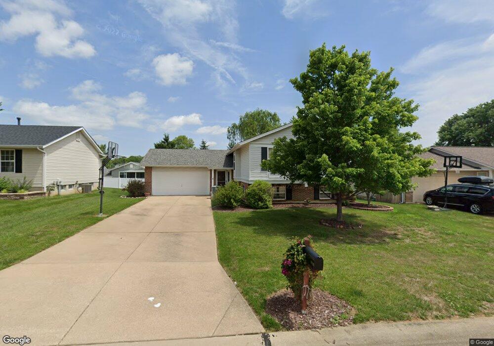
6429 Clover Farm Dr O Fallon, MO 63368
Estimated Value: $292,000 - $303,000
3
Beds
2
Baths
1,129
Sq Ft
$263/Sq Ft
Est. Value
About This Home
This home is located at 6429 Clover Farm Dr, O Fallon, MO 63368 and is currently estimated at $297,120, approximately $263 per square foot. 6429 Clover Farm Dr is a home located in St. Charles County with nearby schools including Pheasant Point Elementary School, Fort Zumwalt South Middle School, and Fort Zumwalt South High School.
Ownership History
Date
Name
Owned For
Owner Type
Purchase Details
Closed on
Jun 16, 2010
Sold by
Remley John F and Remley Stacey L
Bought by
Remley John F and Remley Stacey L
Current Estimated Value
Home Financials for this Owner
Home Financials are based on the most recent Mortgage that was taken out on this home.
Original Mortgage
$143,047
Outstanding Balance
$95,682
Interest Rate
4.93%
Mortgage Type
FHA
Estimated Equity
$201,438
Purchase Details
Closed on
Mar 26, 1998
Sold by
Radcliff Brian
Bought by
Remley John F and Remley Stacy L
Home Financials for this Owner
Home Financials are based on the most recent Mortgage that was taken out on this home.
Original Mortgage
$50,000
Interest Rate
7.17%
Create a Home Valuation Report for This Property
The Home Valuation Report is an in-depth analysis detailing your home's value as well as a comparison with similar homes in the area
Home Values in the Area
Average Home Value in this Area
Purchase History
| Date | Buyer | Sale Price | Title Company |
|---|---|---|---|
| Remley John F | -- | Clear Title Group | |
| Remley John F | -- | -- |
Source: Public Records
Mortgage History
| Date | Status | Borrower | Loan Amount |
|---|---|---|---|
| Open | Remley John F | $143,047 | |
| Closed | Remley John F | $50,000 |
Source: Public Records
Tax History
| Year | Tax Paid | Tax Assessment Tax Assessment Total Assessment is a certain percentage of the fair market value that is determined by local assessors to be the total taxable value of land and additions on the property. | Land | Improvement |
|---|---|---|---|---|
| 2025 | $2,891 | $48,748 | -- | -- |
| 2023 | $2,893 | $43,738 | $0 | $0 |
| 2022 | $2,549 | $35,882 | $0 | $0 |
| 2021 | $2,555 | $35,882 | $0 | $0 |
| 2020 | $2,376 | $32,117 | $0 | $0 |
| 2019 | $2,382 | $32,117 | $0 | $0 |
| 2018 | $2,269 | $29,256 | $0 | $0 |
| 2017 | $2,228 | $29,256 | $0 | $0 |
| 2016 | $2,120 | $26,735 | $0 | $0 |
| 2015 | $1,976 | $26,735 | $0 | $0 |
| 2014 | $1,910 | $25,494 | $0 | $0 |
Source: Public Records
Map
Nearby Homes
- 6513 Sprucefield Dr
- 1006 Golden Orchard Dr
- 249 Dardenne Farms Dr
- 178 Christina Marie Dr
- 661 Clifton Hill Dr
- 219 Braddock Way
- 67 Simeon Ct
- 136 Jacobs Way
- 93 Arapahoe Basin Ct
- 3 Royallbend Ct
- 2628 Breckenridge Cir
- 1319 Commons Cir
- 367 Shamrock St
- 361 Shamrock St
- 1313 Commons Cir
- 2726 Brook Meadow Ln
- 6025 Mo-N Unit # 1
- 6024 Mo-N Unit #2
- 9007 Camino Trail
- 9028 Camino Trail
- 6425 Clover Farm Dr
- 6433 Clover Farm Dr
- 6428 Windy Wheat Dr
- 6432 Windy Wheat Dr
- 6424 Windy Wheat Dr
- 6437 Clover Farm Dr
- 6421 Clover Farm Dr
- 6430 Clover Farm Dr
- 6426 Clover Farm Dr
- 6436 Windy Wheat Dr
- 6434 Clover Farm Dr
- 6420 Windy Wheat Dr
- 6422 Clover Farm Dr
- 6441 Clover Farm Dr
- 6438 Clover Farm Dr
- 6413 Clover Farm Dr
- 6440 Windy Wheat Dr
- 6418 Clover Farm Dr
- 6418 Clover Farms Dr
- 6427 Windy Wheat Dr