


643 N Rope Mill Rd Woodstock, GA 30188
Estimated payment $28,833/month
Highlights
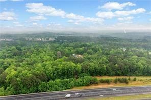
- View of Trees or Woods
- 27.2 Acre Lot
- Fenced
- Woodstock Elementary School Rated A-
About This Lot
Prime 27.2-Acre Investment Opportunity – Exceptional Commercial Development Potential. Strategically located near the intersection of Sixes Road and Main Street, this 27.2-acre property offers a rare opportunity for commercial development in fast-growing Cherokee County. With approximately 2,529 feet of road frontage along North Rope Mill Road and 376 feet along I-575 on Tract A (7 acres), this property boasts outstanding visibility and accessibility. Currently zoned Agricultural, the land is identified for Commercial Development under the county's future land use plan—making it an ideal site for a wide range of investment projects. Key Highlights: Just 1.4 miles to WellStar Cherokee Health Park. Only 0.7 miles to Home Depot, 0.9 miles to Kroger Grocery and Pharmacy. Approximately 4.7 miles to Downtown Woodstock, GA, 3.1 miles to Holly Springs, GA. Walk to Olde Rope Mill Park. Excellent topography with no floodplain. High traffic counts and strong area growth. This parcel is being sold as-is. Showings by appointment only. Whether you're an experienced developer or a savvy investor looking for a foothold in one of Cherokee County's most dynamic corridors, this property presents unmatched potential.
Listing Agent
Berkshire Hathaway HomeServices Georgia Properties License #201355 Listed on: 09/12/2025

Property Details
Property Type
- Land
Est. Annual Taxes
- $5,365
Lot Details
- 27.2 Acre Lot
- Property fronts an interstate
- Fenced
- Sloped Lot
- Property is zoned R40
Schools
- Woodstock Elementary And Middle School
- Woodstock High School
Utilities
- Phone Available
- Cable TV Available
Additional Features
- Views of Woods
- Residence on Property
Community Details
- Property has a Home Owners Association
Listing and Financial Details
- Assessor Parcel Number 15N16 050
Map
Home Values in the Area
Average Home Value in this Area
Tax History
| Year | Tax Paid | Tax Assessment Tax Assessment Total Assessment is a certain percentage of the fair market value that is determined by local assessors to be the total taxable value of land and additions on the property. | Land | Improvement |
|---|---|---|---|---|
| 2025 | $8,193 | $312,000 | $275,600 | $36,400 |
| 2024 | $5,365 | $206,440 | $172,240 | $34,200 |
| 2023 | $5,390 | $207,400 | $172,240 | $35,160 |
| 2022 | $5,154 | $196,080 | $172,240 | $23,840 |
| 2021 | $4,600 | $162,040 | $143,560 | $18,480 |
| 2020 | $4,545 | $159,960 | $143,520 | $16,440 |
| 2019 | $4,477 | $157,560 | $143,520 | $14,040 |
| 2018 | $4,568 | $159,800 | $146,320 | $13,480 |
| 2017 | $4,377 | $379,800 | $138,120 | $13,800 |
| 2016 | $3,978 | $341,600 | $123,800 | $12,840 |
| 2015 | $3,508 | $298,300 | $104,760 | $14,560 |
| 2014 | $3,086 | $261,900 | $90,480 | $14,280 |
Property History
| Date | Event | Price | List to Sale | Price per Sq Ft |
|---|---|---|---|---|
| 09/12/2025 09/12/25 | For Sale | $5,412,601 | -- | -- |
Purchase History
| Date | Type | Sale Price | Title Company |
|---|---|---|---|
| Quit Claim Deed | -- | -- |
Source: First Multiple Listing Service (FMLS)
MLS Number: 7648755
APN: 015N16-00000-050-000-0000
Disclaimer: Certain information contained herein is derived from information provided by parties other than Homes.com. All information provided is deemed reliable, but is not guaranteed to be accurate and should be independently verified.
![]() Listings identified with the FMLS IDX logo come from FMLS and are held by brokerage firms other than the owner of this website. The listing brokerage is identified in any listing details. Information is deemed reliable but is not guaranteed. If you believe any FMLS listing contains material that infringes your copyrighted work please visit www.fmls.com/dmca to review our DMCA policy and learn how to submit a takedown request. © 2025 First Multiple Listing Service, Inc.
Listings identified with the FMLS IDX logo come from FMLS and are held by brokerage firms other than the owner of this website. The listing brokerage is identified in any listing details. Information is deemed reliable but is not guaranteed. If you believe any FMLS listing contains material that infringes your copyrighted work please visit www.fmls.com/dmca to review our DMCA policy and learn how to submit a takedown request. © 2025 First Multiple Listing Service, Inc.
- 643 N Rope Mill Rd Unit 634
- 702 Barberry Dr
- 530 Georgia Way
- 1557 River Park Blvd
- 544 Ridge View Crossing
- 184 Swanee Ln Unit 1C
- 363 Hiawassee Dr
- 295 Hiawassee Dr
- 208 Etowah Way
- 2295 Ansley Ct
- 490 Payne Rd
- 414 Ruths Blvd
- 501 Ruths Dr
- 104 Kremer Falls Trc
- 104 Kremer Falls Trace
- 635 Stately Dr
- 5541 Old Highway 5
- 314 Pin Oak Ave
- 252 Hiawassee Dr
- 1151 Heights Pkwy
- 316 Alcovy Way
- 219 Turner Ln
- 4501 Holly Springs Pkwy
- 4416 Holly Springs Pkwy
- 421 Red Coat Ln
- 100 Holly Park Ct
- 384 Whitetail Cir
- 156 Chapelcrest Ln
- 1003 Ridgewalk Pkwy
- 172 Wallnut Hall Cir
- 1003 Ridgewalk Pkwy Unit 4316
- 1003 Ridgewalk Pkwy Unit 2211
- 1003 Ridgewalk Pkwy Unit 3004
- 607 Wallnut Hall Trail
- 312 Lincoln St
- 732 Mulberry Walk
- 1 Elena Way